Peterborough, England, United Kingdom — Northwestern Europe (the British Isles)
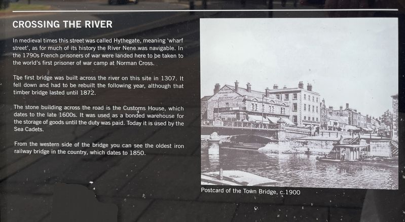
Crossing the River
Photographed by Ray Gurganus, May 3, 2026
1. Crossing the River Marker
The first bridge was built across the river on this site in 1307. It fell down and had to be rebuilt the following year, although that timber bridge lasted until 1872.
The stone building across the road is the Customs House, which dates to the late 1600s. It was used as a bonded warehouse for the storage of goods until the duty was paid. Today it is used by the Sea Cadets.
From the western side of the bridge you can see the oldest iron railway bridge in the country, which dates to 1850.
Topics. This historical marker is listed in this topic list: Bridges & Viaducts.
Location. 52° 34.129′ N, 0° 14.512′ W. Marker is in Peterborough, England. It is on Bridge Street, on the right when traveling south. The marker is mounted to an informational kiosk, just below the area map. Touch for map. Marker is at or near this
this page online

Regionally, this marker is in East Anglia. Globally, it is on the Atlantic Ocean, in the North Atlantic Region, in Europe, in Atlantic Europe, on one of the British Isles, in the Western World, and in the Anglosphere. Historically, it finds itself in what was once the Roman Empire.
Other nearby markers. At least 8 other markers are within walking distance of this marker: Foundry Walk (about 90 meters away, measured in a direct line); Narrow Bridge Street (about 180 meters away); Abbey and Cathedral (approx. 0.4 kilometers away); Simon Gunton (approx. 0.4 kilometers away); St Thomas Becket (approx. 0.4 kilometers away); The Guildhall (approx. 0.4 kilometers away); Welcome to Peterborough Cathedral (approx. 0.4 kilometers away); Markets and Monarchs (approx. 0.4 kilometers away). Touch for a list and map of all markers in Peterborough.
Credits. This page was last revised on July 23, 2026. It was originally submitted on July 22, 2026, by Ray Gurganus of Washington, District of Columbia. This page has been viewed 9 times since then. Photo 1. submitted on July 22, 2026, by Ray Gurganus of Washington, District of Columbia. • Andrew Ruppenstein was the editor who published this page.
Editor’s want-list for this marker. photo of the marker within its surroundings • Can you help?
