
Wymondham in Norfolk, England, United Kingdom — Northwestern Europe (the British Isles)
Wymondham Abbey
Photographed by Ray Gurganus, April 22, 2026
1. Wymondham Abbey Marker
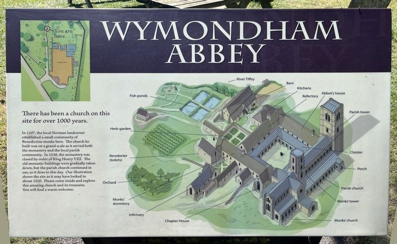
In 1107, the local Norman landowner established a small community of Benedictine monks here. The church he built was on a grand scale as it served both the monastery and the local parish community. In 1538, the monastery was closed by order of King Henry VIII. The old monastic buildings were gradually taken down, but the parish church continued in use, as it does to this day. Our illustration shows the site as it may have looked in about 1520. Please come inside and explore this amazing church and its treasures. You will find a warm welcome.
Topics. This historical marker is listed in this topic list: Religion & Religious Structures. A significant historical year for this entry is 1107.
Location. 52° 34.239′ N, 1° 6.494′ E. Marker is in Wymondham, England, in Norfolk. It can be reached from Church Street, on the left when traveling west. Touch for map. Marker is at or near this postal address: 21 Church Street, Wymondham, England NR18 0PH, United Kingdom. Touch for directions.

Regionally, this marker is in England’s East Anglia. Globally, it is on
this page online
Other nearby markers. At least 8 other markers are within 14 kilometers of this marker, measured as the crow flies: Welcome to Wymondham: A Historic Market Town (approx. 0.9 kilometers away); St Mary's Church (approx. 8.4 kilometers away); The Bassingham Gateway (approx. 14 kilometers away); All Saints, Westlegate (approx. 14.1 kilometers away); 33 Timberhill (approx. 14.1 kilometers away); St Christopher's Church (approx. 14.4 kilometers away); Elm Hill (approx. 14.4 kilometers away); United Reformed Church (approx. 14.4 kilometers away).
Photographed by Ray Gurganus, April 22, 2026
2. Wymondham Abbey
circa 1905
3. Wymondham Church
Credits. This page was last revised on July 22, 2026. It was originally submitted on July 22, 2026, by Ray Gurganus of Washington, District of Columbia. This page has been viewed 6 times since then. Photos: 1, 2. submitted on July 22, 2026, by Ray Gurganus of Washington, District of Columbia. 3. submitted on July 22, 2026. • Andrew Ruppenstein was the editor who published this page.
