Monroe Township near West Liberty in Logan County, Ohio — The American Midwest (Great Lakes)
They Lived Long on the Land
A Castle as a Farmhouse
Photographed by Craig Doda, July 11, 2026
1. They Lived Long on the Land Marker
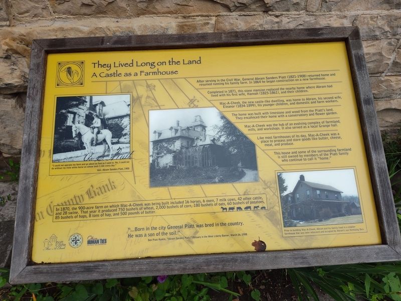
After serving in the Civil War, General Abram Sanders Piatt (1821-1908) returned home and resumed running his family farm. In 1864 he began construction on a new farmhouse.
Completed in 1871, this stone mansion replaced the nearby home where Abram had lived with his first wife, Hannah (1823-1861), and their children.
Mac-A-Cheek, the new castle-like dwelling, was home to Abram, his second wife, Eleanor (1834-1899), his younger children, and domestic and farm workers.
The home was built with limestone and wood from the Piatt's land. They encahnced their home with a convervatory and flower garden.
Mac-A-Cheek was the hub of an evolving complex of farmland, mills, and workshops. It also served as a local Grange hall.
Like most farmhouses of its day, Mac-A-Cheek was a place to process and store goods like butter, cheese, meat, and produce.
This house and some of the surrounding farmland is still owned by members of the Piatt family who continue to call it "home."
In 1870, the 900-acre farm on which Mac-A-Cheek was being built included 16 horses, 6 oxen, 7 milk cows, 42 other cattle, and 28 swine. That
this page online
"I could not operate my farm and go about on foot as I used to. No, I could not do without my little white horse on whose back I ride every day."
Gen. Abram Sanders Piatt, 1905
Prior to building Mac-A-Cheek, Abram and his family lived in a smaller farmhouse that was later relocated and occupied by Abram's son Kentucky Ben.
"…Born in the city General Piatt was bred in the country. He was a son of the soil."
Ben Piatt Runkle, "Abram Sanders Piatt," Obituary in the West Liberty Banner, March 26, 1908
Erected by Piatt Castle Mac-A-Cheek; The Mac-A-Cheek Foundation for the Humanities; Ohio Humanities.
Topics. This historical marker is listed in these topic lists: Architecture • Forts and Castles • Settlements & Settlers. A significant historical date for this entry is March 26, 1908.
Location. 40° 15.059′ N, 83° 43.608′ W. Marker is near West Liberty, Ohio, in Logan County. It is in Monroe Township. It is at the intersection of County Route 47 and Ohio Route
Photographed by Craig Doda, July 11, 2026
2. They Lived Long on the Land Marker

Regionally, this marker is in Ohio’s Till Plains. It is also in the American Midwest and in the Corn Belt. Globally, it is in North America, the Western Hemisphere, the Western World, and the Anglosphere. Historically, it finds itself in what was once the Viceroyalty of New France, the Haudenosaunee (Iroquois) Confederacy, the territory of the Mississippian Culture, and the Northwest Territory.
Other nearby markers. At least 8 other markers are within walking distance of this marker: A Castle as a Farmhouse (here, next to this marker); Over a Century of Tours (here, next to this marker); Who's in the Dog House? (a few steps from this marker); Let's Play (a few steps from this marker); What Happened to the Conservatory? (a few steps from this marker); Connecting the Conservatory to the Garden (a few steps from this marker); Industry on the Macacheek (a few steps from this marker); Over a Century of Tours: Family Business (a few steps from this marker). Touch for a list and map of all markers in West Liberty.
Credits. This page was last revised on August 6, 2026. It was originally submitted on July 30, 2026, by Craig Doda of Napoleon, Ohio. This page has been viewed 19 times since then. Photos: 1, 2. submitted on July 30, 2026, by Craig Doda of Napoleon, Ohio. • Devry Becker Jones was the editor who published this page.
