Monroe Township near West Liberty in Logan County, Ohio — The American Midwest (Great Lakes)
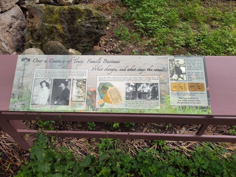
Over a Century of Tours: Family Business
What changes, and what stays the same?
Photographed by Craig Doda, July 11, 2026
1. Over a Century of Tours: Family Business Marker
As children, Marguerite and Bertie Piatt knew Mac-A-Cheek as their grandfather's home. By their thirties they were living here and helping their father, William McCoy Piatt, give tours. Their family home had become a family business, which they continued after his death in 1927. Bertie and Marguerite remembered their father by carrying on his business and commissioning this stone relief of his image.
Just as their father memorialized his ancestors in the souvenir booklet he published, Bertie and Marguerite sold fans commemorating family members' military careers. Like others during the Colonial Revival period, they connected their history to the early history of this country.
While a visitor today might tag Piatt Castles in a photo on social media, Rev. Lincoln Long mailed this photo back to Bertie Piatt after his visit in 1935. Eventually, the family produced their own post cards for sale.
Bertie Piatt was born ten years after Mac-A-Cheek was completed. By the time this photo was taken in the 1940s, she had managed the business through both World Wars and the Great Depression.
When her nephews Bill and Jim, returned
this page online
These tickets from the early 1940s show the addition of a war tax to the price of admission.
How have traditions in your family changed from one generation to the next?
Erected by Piatt Castle Mac-A-Cheek; The Mac-A-Cheek Foundation for the Humanities; The Columbus Foundation; Mary Eleanor Morris Fund.
Topics. This historical marker is listed in these topic lists: Architecture • Education • Industry & Commerce • War, World II. A significant historical year for this entry is 1927.
Location. 40° 15.058′ N, 83° 43.622′ W. Marker is near West Liberty, Ohio, in Logan County. It is in Monroe Township. It is at the intersection of County Route 47 and Ohio Route 245, on the right when traveling north on County Route 47. Touch for map. Marker is at or near this postal address: 10051 Township Rd 47, West Liberty OH 43357, United States of America. Touch for directions.

Regionally, this marker is in the Till Plains. It is also in the American Midwest and in the Corn Belt. Globally, it is in North America, the Western Hemisphere,
Photographed by Craig Doda, July 11, 2026
2. Over a Century of Tours: Family Business Marker
Other nearby markers. At least 8 other markers are within walking distance of this marker: Connecting the Conservatory to the Garden (here, next to this marker); Aftermath of Logan’s Raid (here, next to this marker); What Happened to the Conservatory? (here, next to this marker); Hopewell Ceremonial Earthworks (here, next to this marker); A History of Historic Markers (here, next to this marker); How the Mekoche Were Remembered (here, next to this marker); Finding the Balance Between History & Legacy (here, next to this marker); Why aren't we standing in a Shawnee village? (here, next to this marker). Touch for a list and map of all markers in West Liberty.
Credits. This page was last revised on August 6, 2026. It was originally submitted on July 30, 2026, by Craig Doda of Napoleon, Ohio. This page has been viewed 15 times since then. Photos: 1, 2. submitted on July 30, 2026, by Craig Doda of Napoleon, Ohio. • Devry Becker Jones was the editor who published this page.
