Monroe Township near West Liberty in Logan County, Ohio — The American Midwest (Great Lakes)
Why do Families Move?
Photographed by Craig Doda, July 11, 2026
1. Why do Families Move? Marker
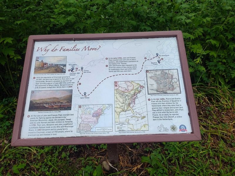
🅐 In the late 1600s, Pierre and Estelle Piatt left the Province of Dauphine in France with their children for the Netherlands where they were free to practice their religion and to own land. They settled in Amsterdam. John Piatt was a child when his family left France. As an adult, he married Frances Van Vliet Wykoff, a widow born in the Netherlands.
🅑 In the early 1740s, John and Frances Piatt traveled west with one of John's brothers, who established a plantation on the Island of St. Thomas.
🅒 John and Frances then migrated to the American colony of New Jersey where he established a farm and where their fourth and fifth sons were born.
🅓 All five sons of John and Frances Piatt received land grants for fighting against the British in the American Revolution. Jacob, the youngest, moved with his wife Hannah and their children to Kentucky in 1795. Their sons, Benjamin and John, established a profitable flatboat trade on the Ohio and Mississippi Rivers. In 1803 Benjamin and his young family moved to Cincinnati, a town of 750 people, where he practiced law and invested in land.
🅔
this page online
Erected by Piatt Castle Mac-A-Cheek; The Mac-A-Cheek Foundation for the Humanities; America 250: Ohio Commission.
Topics and series. This historical marker is listed in this topic list: Settlements & Settlers. In addition, it is included in the America 250: Ohio Commission series list. A significant historical year for this entry is 1795.
Location. 40° 15.059′ N, 83° 43.63′ W. Marker is near West Liberty, Ohio, in Logan County. It is in Monroe Township. It is at the intersection of County Route 47 and Ohio Route 245, on the right when traveling north on County Route 47. Touch for map. Marker is at or near this postal address: 10051 Township Rd 47, West Liberty OH 43357, United States of America. Touch for directions.

Regionally, this marker is in Ohio’s Till Plains. It is also in the American Midwest and in the Corn Belt. Globally,
Photographed by Craig Doda, July 11, 2026
2. Why do Families Move? Marker
Other nearby markers. At least 8 other markers are within walking distance of this marker: Tribal Divisions in the Past & Tribal Groups Today (here, next to this marker); Past Shawnee Villages (here, next to this marker); Jeepers Creepers (here, next to this marker); Great Council State Park (a few steps from this marker); How the Mekoche Were Remembered (a few steps from this marker); Why aren't we standing in a Shawnee village? (a few steps from this marker); Aftermath of Logan’s Raid (a few steps from this marker); A History of Historic Markers (a few steps from this marker). Touch for a list and map of all markers in West Liberty.
Credits. This page was last revised on August 11, 2026. It was originally submitted on July 30, 2026, by Craig Doda of Napoleon, Ohio. This page has been viewed 9 times since then. Photos: 1, 2. submitted on July 30, 2026, by Craig Doda of Napoleon, Ohio. • Devry Becker Jones was the editor who published this page.
