Centre Erlon in Reims in Marne, Alsace, Lorraine, Champagne-Ardenne, France — Western Europe
Église Saint-Jacques
⎯⎯⎯
Saint-Jacques Church
| — | Visit Reims, Sur les pas de l'Art déco | — |
Photographed by James Hulse
1. Église Saint-Jacques / Saint-Jacques Church Marker

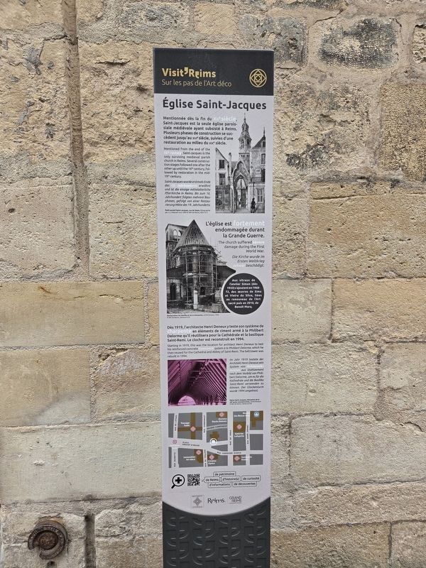
Mentionnée dès la fin du XIIᵉ siècle, Saint-Jacques est la seule église paroissiale médiévale ayant subsisté à Reims. Plusieurs phases de construction se succèdent jusqu'au XVIᵉ siècle, suivies d'une restauration au milieu du XIXᵉ siècle.
L'église est fortement endommagée durant la Grande Guerre.
Aux vitraux de l'atelier Simon (dès 1933) s'ajoutent en 1968-72 des œuvres de Sima et Vieira da Silva, liées au renouveau de l'Art sacré puis en 2010, de Benoît Marq.
Dès 1919, l'architecte Henri Deneux y teste son système de charpente en éléments de ciment armé à la Philibert Delorme qu'il réutilisera pour la cathédrale et la basilique Saint-Remi. Le clocher est reconstruit en 1994.
Petit portail Saint-Jacques, rue de Vesle, lithographie par J. J. Maquart vers 1850 © BM de Reims, XXVIe 3
Restauration de l’abside et de la charpente, cliché Deneux, 1926 © BM de Reims, Deneux R 29
Église Saint-Jacques, charpente de la nef après reconstruction, cliché Deneux © BM de Reims, Deneux R 50
this page online
The church suffered severe damage during the First World War.
Starting in 1919, this was the location for architect Henri Deneux to test his reinforced-concrete framework system à la Philibert Delorme, which he then reused for the Cathedral and Abbey of Saint-Remi. The bell tower was rebuilt in 1994.
Small Portal of Saint-Jacques, Rue de Vesle, lithograph by J. J. Maquart, around 1850 © Reims Municipal Library, XXVIe 3
Restoration of the apse and roof structure, photograph by Deneux, 1926 © Reims Municipal Library, Deneux R 29
Saint-Jacques Church, roof structure of the nave after reconstruction, photograph by Deneux © Reims Municipal Library, Deneux R 50
Die Kirche wurde im Ersten Weltkrieg schwer beschädigt.
Im Jahr 1919 testete

Photographed by James Hulse, August 5, 2026
2. Église Saint-Jacques / Saint-Jacques Church Marker
Kleines Portal der Kirche Saint-Jacques, Rue de Vesle, Lithografie von J. J. Maquart, um 1850 © Stadtbibliothek Reims, XXVIe 3
Restaurierung der Apsis und des Dachstuhls, Fotografie von Deneux, 1926 © Stadtbibliothek Reims, Deneux R 29
Kirche Saint-Jacques, Dachstuhl des Kirchenschiffs nach dem Wiederaufbau, Fotografie von Deneux © Stadtbibliothek Reims, Deneux R 50
Erected by Historic Monument, City of Reims, Greater Reims Urban Community.
Topics. This historical marker is listed in this topic list: Religion & Religious Structures. A significant historical year for this entry is 2010.
Location. 49° 15.239′ N, 4° 1.688′ E. Marker is in Reims, Grand Est (Alsace, Lorraine, Champagne-Ardenne), in Marne. It is in Centre Erlon. It is at the intersection of Place Drouet d'Erlon and Rue Condorcet, on the left when traveling south on Place Drouet d'Erlon. Touch for map. Marker is at or near this postal
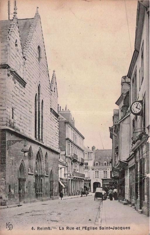
circa 1913
3. La Rue and the Église Saint-Jacques
Looking south, taken from roughly the location as the previous photo, showing the east side of the church

Regionally, it is in the North Atlantic Region, Europe, the European Union, Atlantic Europe, the Schengen Area, Western Europe, a coastal Mediterranean country, and the Western World. Historically, it finds itself in what was once a French colony, the Roman Empire, and specifically the Holy Roman Empire.
Other nearby markers. At least 8 other markers are within walking distance of this marker: Place d’Erlon (within shouting distance of this marker); Place Drouet-d’Erlon (within shouting distance of this marker); Cinéma Opéra (within shouting distance of this marker); Immeuble de rapport Kodak / Kodak Apartment Building (about 90 meters away, measured in a direct line); Rue de Vesle et Magasins Modernes (about 90 meters away); Fontaine Subé (about 150 meters away); Hommage aux martyrs de la Résistance française / Tribute to the Martyrs of the French Resistance (about 150 meters away); Opéra, ancien Grand Théâtre / Opera, Former Grand Théâtre (about 180 meters away). Touch for a list and map of all markers in Reims.

circa 1905
4. Place Drouet-d’Erlon and Église Saint-Jacques
Looking south, taken from about 25 meters north of the preceding photos, visible are the church’s belltower (with clock), and to the right of that the roofline and eastern side of the church, as well

Photographed by M.I. Imp., Limoges, circa 1918
5. Place Drouet-d’Erlon and Église Saint-Jacques
Looking south, taken from a few steps further north than the preceding photo, showing the wartime damage to the immediate vicinity of the church, as well as the church itself, now missing its belltower and roof
Credits. This page was last revised on August 14, 2026. It was originally submitted on August 7, 2026, by James Hulse of Medina, Texas. This page has been viewed 16 times since then. Photos: 1, 2. submitted on August 10, 2026, by James Hulse of Medina, Texas. 3, 4, 5. submitted on August 11, 2026.
