Centre-Ville in Reims in Marne, Alsace, Lorraine, Champagne-Ardenne, France — Western Europe
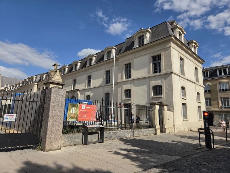
Palais du Tau
⎯⎯⎯
Palace of Tau
| — | Visit Reims, Cité des sacres | — |

Photographed by James Hulse, August 5, 2026
1. Palais du Tau / Palace of Tau Marker

Implanté sur un site gallo-romain, peut-être le palais du gouverneur, le bâtiment devient la résidence de l’évêque au moment où la première cathédrale est bâtie, vers 400, à l’emplacement actuel. D’importants travaux sont attestés à l’époque carolingienne, lui donnant un plan en forme de T, d’où il tire son nom.
C’est là que le roi est logé lorsqu’il vient se faire sacrer ; il préside dans la grande salle le festin qui clôt la cérémonie. Le palais est doté d’une chapelle gothique au XIIIᵉ siècle, d’éléments flamboyants au XVe siècle, d’une façade classique à la fin du XVIIᵉ siècle.
Incendié en 1914, il a été en partie reconstruit, pour devenir un musée, ouvert en 1972.
Appartenant à l’État et géré par le Centre des monuments nationaux, il présente des collections sur l’histoire de la cathédrale (trésor, tapisseries, sculptures déposées) et des sacres.
Plan de l’église métropolitaine de Reims et du Palais de l’Archevêché, XVIIIᵉ siècle
Sacres de Charles VII en 1429, le Festin © BM de Reims V 1d 15
Ruines du Palais Épiscopal après le bombardement du 19 septembre 1914, anonyme, 1914 © BM Reims, carte postale 55-012
this page online
This is where the king was accommodated when being crowned; he would have presided over the festivities that concluded the ceremonies, in the great hall. A Gothic chapel was added to the palace in the 13th century, with additional flamboyant elements in the 16th century, and a classical façade at the end of the 17th century.
Having been burnt down in 1914, it was partly reconstructed, and became a museum, which opened in 1972.
It is owned by the state and managed by the Centre des monuments nationaux, and exhibits collections on the history of the cathedral (treasures, tapestries, removed sculptures) and of the coronations.
Plan of the Metropolitan Church of Reims and the Archbishop’s Palace, 18th century
Coronation of Charles VII in 1429, the Banquet © Reims Municipal Library
Ruins of the Episcopal Palace after the bombardment of September 19, 1914, anonymous, 1914 © Reims Municipal Library, postcard 55-012
Photographed by James Hulse, August 5, 2026
2. Palais du Tau / Palace of Tau Marker
Zum Anlass seiner Krönung verweilte der König hier als Gast in dem großen Saal, präsidierte er dem Festmahl, mit dem die Krönungszeremonie endete. Neben einer gotischen Palastkapelle aus dem 13. Jahrhundert finden wir Elemente der Spätgotik aus dem 16. Jahrhundert, sowie eine Ende des 17. Jahrhunderts erbaute klassische Fassade.
Nachdem der Taupalast 1914 ausbrannte, wurde er restauriert und zu einem Museum ausgebaut, das 1972 öffnete.
Als staatliches Museum wird der Taupalast vom Zentrum für Nationale Bauwerke verwaltet. Es zeigt Sammlungen zur Geschichte der Kathedrale (Domschatz, Wandteppiche, ein Depot der Steinskulpturen) und Geschichte der Krönungen.
Plan der Metropolitankirche von Reims und des Erzbischöflichen Palastes, 18. Jahrhundert
Krönung Karls VII. im Jahr 1429, das Festmahl © Stadtbibliothek Reims
Ruinen des Bischofspalastes nach dem Bombardement vom 19. September 1914, anonym, 1914 © Stadtbibliothek Reims, Postkarte 55-012
Erected by Historic

Photographed by James Hulse, August 5, 2026
3. Palais du Tau / Palace of Tau Marker
The view of the marker with the cathedral in the background.
Topics. This historical marker is listed in this topic list: Notable Buildings. A significant historical date for this entry is September 19, 1914.
Location. 49° 15.181′ N, 4° 2.01′ E. Marker is in Reims, Grand Est (Alsace, Lorraine, Champagne-Ardenne), in Marne. It is in Centre-Ville. It is at the intersection of Place du Cardinal Luçon and Rue Cardinal de Lorraine, on the right when traveling north on Place du Cardinal Luçon. Touch for map. Marker is at or near this postal address: 2 Pl du Cardinal Luçon, Reims, Grand Est 51100, France. Touch for directions.

Regionally, it is in the North Atlantic Region, Europe, the European Union, Atlantic Europe, the Schengen Area, Western Europe, a coastal Mediterranean country, and the Western World. Historically, it finds itself in what was once a French colony, the Roman Empire, and specifically the Holy Roman Empire.
Other nearby markers. At least 8 other markers are within walking distance of this marker: Architectures romantiques et modernistes / Romantic and Modernist Architecture (within shouting distance of this marker); Cathédrale Notre-Dame

Photographed by Phototypie Baudinier, circa 1914
4. Ruines de REIMS - Palais Archi-Episcopal / The Bishops-Palace
The Reims Cathredral and neighboring Bishop's Palace were heavily damaged by the German bombardment of the city on September 18-19, 1914, as depicted on this postcard view of the damaged palace. (Click on photo to enlarge.)
Other markers no longer nearby. Palais du Tau (was a few steps from this marker but has been replaced with another marker now near it); Cathédral Notre-Dame (was within shouting distance of this marker but has been replaced with another marker now near it); Médiathèque Jean Falala (was about 90 meters away, measured in a direct line but has been replaced with another marker now near it).
Credits. This page was last revised on August 14, 2026. It was originally submitted on August 12, 2026, by James Hulse of Medina, Texas. This page has been viewed 16 times since then. Photos: 1, 2, 3. submitted on August 13, 2026, by James Hulse of Medina, Texas. 4. submitted on August 13, 2026.
