Goostrey in Cheshire East, England, United Kingdom — Northwestern Europe (the British Isles)
Manchester - Goostrey - Crewe
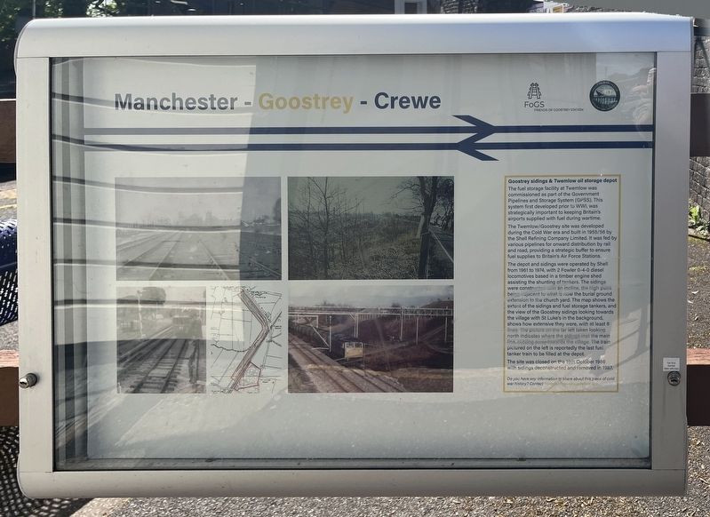
Goostrey sidings & Twemlow oil storage depot
Photographed by Ray Gurganus, May 10, 2026
1. Manchester - Goostrey - Crewe Marker
The Twemlow/Goostrey site was developed during the Cold War era and built in 1956/56 by the Shell Refining Company Limited. It was fed by various pipelines for onward distribution by rail and road, providing a strategic buffer to ensure fuel supplies to Britain's Air Force Stations.
The depot and sidings were operated by Shell from 1961 to 1974, with 2 Fowler 0-4-0 diesel locomotives based in a timber engine shed assisting the shunting of tankers. The sidings were constructed with an incline, the high point being adjacent to what is now the burial ground extension to the churchyard. The map shows the extent of the sidings and fuel storage tankers, and the view of the Goostrey sidings looking towards the village with St Luke's in the background, shows how extensive they were, with at least 8 lines. The picture on the far left taken looking north indicates where the sidings
this page online
The site was closed on the 19th October 1986 with sidings deconstructed and removed in 1987.
Erected by Friends of Goostrey Station.
Topics. This historical marker is listed in this topic list: Railroads & Streetcars.
Location. 53° 13.348′ N, 2° 19.597′ W. Marker is in Goostrey, England, in Cheshire East. It can be reached from Station Road. Touch for map. Marker is at or near this postal address: 69 Station Road, Goostrey, England CW4 8PJ, United Kingdom. Touch for directions.

Regionally, this marker is in North West England. Globally, it is on the Atlantic Ocean, in the North Atlantic Region, in Europe, in Atlantic Europe, on one of the British Isles, in the Western World, and in the Anglosphere. Historically, it finds itself in what was once the Roman Empire.
Other nearby markers. At least 8 other markers are within 26 kilometers of this marker, measured as the crow flies: Welcome to the Holmes Chapel Conservation Area (approx. 3.1 kilometers away); Welcome to Mill Street (approx. 14 kilometers away); Milton House & Gardens (approx. 14.2 kilometers away); Crewe (approx. 16 kilometers away); The Great Church of St Mary's (approx. 21.6 kilometers away); Channel Island Evacuees (approx. 23.2 kilometers away); Heaton Norris, Viaduct (approx. 24.6 kilometers away); Heaton Chapel, George & Dragon (approx. 24.6 kilometers away).
Credits. This page was last revised on August 13, 2026. It was originally submitted on August 13, 2026, by Ray Gurganus of Washington, District of Columbia. This page has been viewed 14 times since then. Photo 1. submitted on August 13, 2026, by Ray Gurganus of Washington, District of Columbia. • Andrew Ruppenstein was the editor who published this page.
Editor’s want-list for this marker. photo of the marker within its surroundings • Can you help?
