Holborn in Camden in Greater London, England, United Kingdom — Northwestern Europe (the British Isles)
History of Red Lion Square Gardens 1860-1960

Photographed by Andrew Ruppenstein, April 24, 2026
1. History of Red Lion Square Gardens 1860-1960 Marker
Deputy Sheriff of London
Around 1860, John Philipps Emslie painted the east side of Red Lion Square, in particular Nos. 22, 23 and 24. No. 24 was the Ancient Baronial Court, held under the authority of the Sheriffs of Middlesex. "It is held monthly" (says the Gentleman's Magazine in 1829) "before the Sheriff or his Deputy. Its power in judgment is as great as that of the present Courts at Westminster. It is more expeditious and less expensive; persons seeking to recover debts may do so to any amount at the trifling expense of only six or seven pounds. From 1842, the Sheriff's Officer, and later Deputy Sheriff of Middlesex, was a member of the Burchell family. In 1890, the office became Deputy Sheriff of the County of London, still at 24 Red Lion Square, until May 1941, when the premises were destroyed.
Laying Out the Garden and Transport Links
In 1885, the Metropolitan Gardens Association planted a garden in the Square, which was made open to the general public. Professor T. C. Barker said that "the switch from domestic/office/commercial use to commercial/office use" was encouraged by the improved transport links,
this page online
From Rich to Poor
Between 1886 and 1903, Charles Booth collected over 450 volumes of interviews, questionnaires, observations, and statistical information for what was to become his Inquiry into the Life and Labour of the People in London. In 1889, this information was produced as a map.
The map uses a spectrum of dark red to dark blue to map from rich to poor, with "Upper-middle and upper classes, Wealthy" picked in orange and "Lowest class. Vicious, semi-criminal" in black. Red Lion Square, at the time, occupies the middle ground.
St John the Evangelist
Booth's map
Photographed by Andrew Ruppenstein, April 24, 2026
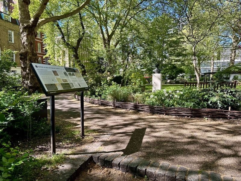
2. History of Red Lion Square Gardens 1860-1960 Marker - wide view
This is one of four different markers presenting the history of Red Lion Square Gardens and the immediate vicinity, with each placed at the each of the four entrance gates. This one is located at the eastern entrance.
Summit House
The first half of the 20th century saw several unique building construction projects on the Square. In 1925, Summit House was built on the site of No. 12 Red Lion Square for the Austin Reed Company. The Austin Reed menswear company was founded in 1900 and by the 1920s had a flagship store on London's Regent Street. The company commissioned the architectural practice of Westwood & Emberton to design a London headquarters for the company.
Conway Hall
In 1927, South Place Ethical Society, now Conway Hall Ethical Society, purchased the plot of 25 Red Lion Square and Numbers 14 to 20 Lambs Conduit Passage that both used to form part of the Strictland Estate and upon which used to stand a school.
Following a successful appeal fund from its members, Conway Hall Ethical Society raised enough money to realise Frederick Herbert Mansford's architectural vision for Conway Hall.
Hanway House
In 1938, Hanway House was

Photographed by John Philipp Emslie, April 24, 2026
3. Marker illustration: Red Lion Square Nos. 24, 23 and 22 (circa 1860)
Progress and fortunes seemed in full swing, with new construction projects and transport infrastructure giving a different shape to the Square and its immediate surroundings. However, everything for the Square was about to change.
World War II
Eighteen months after the start of World War II, Red Lion Square was bombed during the Blitz. On Wednesday, 17 April 1941, a parachute mine destroyed St John the Evangelist church. Over 1,000 people died that night across London.
Then, on their last major London raids on 10 and 11 May 1941 the Luftwaffe bombed Red Lion Square. This time, Nos. 23 and 24 were obliterated ending the Red Lion Square address for the Sheriff of Middlesex and later Deputy Sheriff of London. An unexploded bomb also crashed through the Main Hall roof of Conway Hall.
Red Lion Passage
On the same night, another bomb exploded in Red Lion Passage destroying everything down the passage and Nos. 18, 19, 20, and 21 Red Lion Square - the whole southeastern corner. Red Lion Passage was home to many booksellers.
The Square in Ruins
The Blitz destroyed half of the buildings on the Square, in particular Nos. 35, 36, 37 and 38 were decimated. The Square was forever changed on that May night in 1941.
As London woke up, or more likely dared to venture out after a sleepless night, members of South Place Ethical Society were arriving for their regular Sunday meeting at Conway Hall. Their scheduled speaker for that morning, Dr C. E. M. Joad, an English Philosopher, had this to say:
"My first thought as I approached Red Lion Square this morning was "My God! it's gone..." And then to my immense gratification I saw that although our next door neighbours had gone, Conway Hall remained. Inevitably we are few this morning and I think the question might be raised whether we should hold a meeting and go through the forms or our service at all. We judged it right to do so (cheers)... It is our tradition to meet every Sunday morning, and in the words of propaganda it would be a victory for Hitler if we stopped doing so." In the 1950s, rebuilding started and Red Lion Square gained new apartment blocks in the two bombed out areas on the east side, whilst Red Lion Passage was lost to memory.
Erected by Borough of Camden. (Marker Number 3.)
Topics. This historical marker is listed in these topic lists: Government & Politics • Railroads & Streetcars • Religion & Religious Structures • War, World II. A significant historical year for this entry is 1860.
Location. 51° 31.16′ N, 0° 7.102′ W. Marker is in Camden, England, in Greater London. It is in Holborn. It can be reached from Red Lion Square, on the left when traveling south. Touch for map. Marker is at or near this postal address: 14 Red Lion Square, Camden, England WC2A 3HP, United Kingdom. Touch for directions.

Regionally, this marker is in London and in the Greater South East. Globally, it is on the Atlantic Ocean, in the North Atlantic Region, in Europe, in Atlantic Europe, on one of the British Isles, in the Western World, and in the Anglosphere. Historically, it finds itself in what was once the Roman Empire.
Other nearby markers. At least 8 other markers are within walking distance of this marker: Rosetti, Morris, and Burne-Jones (within shouting distance of this marker); Fanny Wilkinson (within shouting distance of this marker); History of Red Lion Square Gardens 1760-1860 (within shouting distance of this marker); History of Red Lion Square Gardens 1960 - Present (within shouting distance of this marker); John Harrison (within shouting distance of this marker); History of Red Lion Square Gardens 1660-1760 (within shouting distance of this marker); Oliver Cromwell’s Body (about 180 meters away, measured in a direct line); William Richard Lethaby (about 180 meters away). Touch for a list and map of all markers in Camden.
Credits. This page was last revised on August 15, 2026. It was originally submitted on August 15, 2026, by Andrew Ruppenstein of Lamorinda, California. This page has been viewed 15 times since then. Photos: 1, 2, 3. submitted on August 15, 2026, by Andrew Ruppenstein of Lamorinda, California.
