The Bell Diamond

Steel Headframe, New Technology
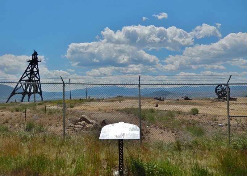
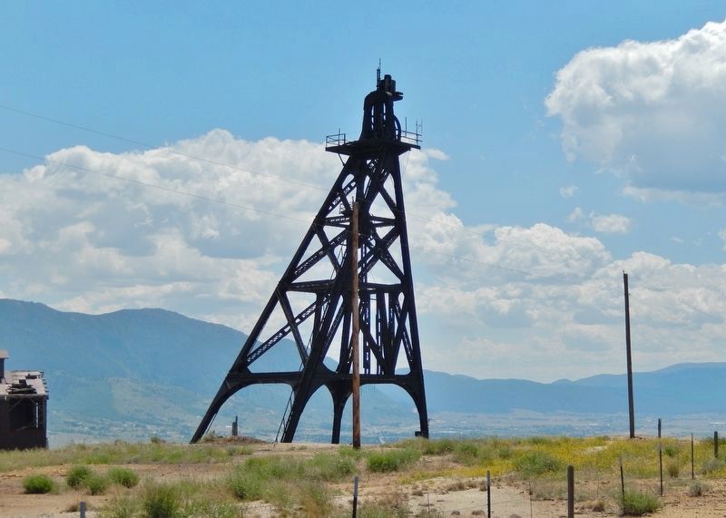
The headframe of the Diamond Mine, erected in 1898 (to your left), is the oldest standing steel headframe on the Hill. The mine is often referred to as the Bell Diamond due to its association with the nearby Bell mine. The steel headframe's construction, and the installation of the earliest first-motion duplex hoist (powered by compressed air) in 1906, were new technologies that allowed mines to go deeper and hoist larger amounts of ore. Portability was another advantage of the steel headframe — they were often moved from one mine to another.
Many Butte mines now lost
Over the years, salvaging, new technologies and reclamation projects have claimed many of Butte's 430 mines. Those include the Leonard, Tramway, Adams, Anaconda, High Ore, Pennsylvania, Gem, Neversweat, St. Lawrence, Rarus, Black Rock, Niagara, Berkeley, Mt. View, East Colusa, West Colusa, Alex Scott, Parnell, Buffalo, Speculator, Milwaukee, Elm Orlu, Alice and Sarsfield.
Mules, horses were vital
Mules and horses were vital to early underground mining operations. Each underground mine level had barns that could hold several mules
this page online
[photo captions]
• Top of the World Trail System [trail map]
• Visitors tour the Bell Diamond Mine early last century.
• Mine workers use a special harness to truss up a mule so that it could be lowered into the Diamond Mine to pull ore cars in 1908. Binding the animal’s legs to its belly and putting a hood over its head was necessary to ensure its safety.
• Double-decker cages in the Bell Diamond Mine holding miners and supplies is ready to be hoisted to the surface. The mine operated from 1882 to 1928 and was worked to a depth of 3,500 feet.
Erected by Montana's Copperway.
Topics. This historical marker is listed in these topic lists: Animals • Industry & Commerce. A significant historical year for this entry is 1898.
Location. 46° 1.55′ N, 112° 31.499′ W.

Regionally, this marker is in andspecifically outhwest Montana, in Gold West Country, in Mining Country. It is also in the American Mountain West and in the Lewis & Clark Corridor. Globally, it is in North America, the Rocky Mountains, the Western Hemisphere, the Western World, and the Anglosphere. Historically, it finds itself in what was once Rupert’s Land and also the Louisiana Purchase.
Other nearby markers. At least 8 other markers are within walking distance of this marker: Women of Butte (about 400 feet away, measured in a direct line); Labor History in Butte, Montana (about 400 feet away); Badger State Mine / The Speculator-Granite Mountain Mine / The Bell-Diamond Mine (about 500 feet away); The Con (approx. 0.3
Also see . . . Bell-Diamond Mine (Story of Butte).
(by Butte Historical Society, & Nancy Woodruff) Excerpt: The Diamond was named by a prospector for the configuration formed by its claim stakes. Originally owned by mining entrepreneur William Clark, this mine figured prominently in his battle with Marcus Daly and Augustus Heinze for control of the Butte copper industry. The mine was ultimately sold to the Anaconda Copper Mining Company in 1895.(Submitted on August 16, 2026, by Cosmos Mariner of Cape Canaveral, Florida.)Erected in 1898, the headframe of the Diamond is the oldest left standing on the hill. In the early days, the miners commuted to work on a streetcar which ran to within a few hundred yards of this site. Among the mine yard buildings here that have gone the way of the trolley is the rope house, which fabricated the flat, seven-inch cables used before the advent of round cable to hoist cages and skips. The large wheels
scattered around the mine yard are sheave wheels. Originally they sat atop other headframes around the hill and guided the hoist cable in and out of the shaft.Photographed by Cosmos Mariner, July 6, 20244. Sheave WheelsLooking south from the Bell Diamond marker.The Bell mine was located about a tenth of a mile east of the Diamond headframe. Ore from the two mines was hoisted through a common shaft by 1914, leading them to be referred to jointly as the Bell-Diamond. The Bell was founded by T.C. Meader of the Montana Mining Company. The mine was acquired by the Anaconda Copper Mining Company in 1885.

Credits. This page was last revised on August 16, 2026. It was originally submitted on August 15, 2026, by Cosmos Mariner of Cape Canaveral, Florida. This page has been viewed 13 times since then. Photos: 1, 2, 3, 4. submitted on August 16, 2026, by Cosmos Mariner of Cape Canaveral, Florida.
