Caret in Essex County, Virginia — The American South (Mid-Atlantic)
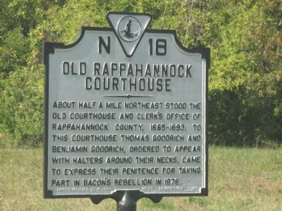
Old Rappahannock Courthouse
Erected 1928 by Conservation & Development Commission. (Marker Number N-18.)
Topics and series. This historical marker is listed in these topic lists: Colonial Era • Government & Politics. In addition, it is included in the Virginia Department of Historic Resources (DHR) series list. A significant historical year for this entry is 1693.
Location. Marker has been permanently removed. It was located near 37° 58.932′ N, 76° 57.575′ W. Marker was in Caret, Virginia, in Essex County. Marker was on Tidewater Trail (U.S. 17) north of Old Courthouse Road, on the right when traveling north. Touch for map. Marker was in this post office area: Caret VA 22436, United States of America.
We have been informed that this sign or monument is no longer there and will not be replaced. This page is an archival view of what was.
Other nearby markers. At least 8 other markers are within 6 miles of this location, measured as the crow flies. Gouldborough Plantation (approx. 2 miles away); Rappahannock Indian Migration (approx. 3˝ miles away); Bountiful Marshes (approx. 4.4 miles away); Rivers of Grass (approx. 4.9 miles away); National Wildlife System (approx. 5 miles away); Pollinators (approx. 5 miles away); Hutchinson Tract (approx. 5 miles away); Toppahanock Indian Village (approx. 5˝ miles away). Touch for a list and map of all markers in Caret.
More about this marker. This marker is no longer listed in the Virginia Department of Historic Resources listings. It is not known when it was damaged/stolen/removed.
Additional commentary.
1. Sign no longer present
My wife and I bought the property last year and were surprised to learn that the marker would have been on our land. Sadly, it's not here any longer, but we would gladly host it again.
— Submitted July 10, 2016, by Tony Dunsworth of Tappahannock, Virginia.
Credits. This page was last revised on September 17, 2020. It was originally submitted on October 21, 2007, by Laura Troy of Burke, Virginia. This page has been viewed 1,679 times since then and 32 times this year. Photo 1. submitted on October 21, 2007, by Laura Troy of Burke, Virginia. • J. J. Prats was the editor who published this page.
