Centerville in Butte in Silver Bow County, Montana — The American West (Mountains)
Mines of Centerville
Photographed by Cosmos Mariner, July 6, 2024
1. Mines of Centerville Marker
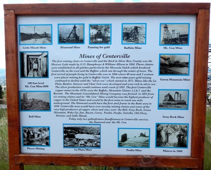
The first mining claim in Centerville and the third in Silver Bow County was the Moscow Lode made by G.O. Humphreys & William Allison in 1864. Placer claims were established in all gulches particularly the Missoula Gulch which bordered Centerville on the west and the Buffalo which ran through the center of town. The first record of people living in Centerville was in 1866 where 40 men and 5 women were placer mining for gold in Buffalo Gulch. The next nine years gold mining continued to decline until the “silver era” which started in 1875. Mines like the La Plata, Banker, Snoozer and Clear Grit were developed and were rich in silver ore. The silver production would continue until crash of 1893. The first Centerville copper mines in the 1870s were the Buffalo, Mountain Claims 1, 2, & 3 and the Burnett. The Mountain Consolidated Mining Company was formed in 1881 from six mining claims and its “Mt. Con” Mine would become the highest producer of copper in the United States and would be the first mine to reach one mile underground. The Diamond would have the first steel frame in the Butte area in 1898. Centerville area would
this page online
Today only two gallusframes (headframes) in Centerville survive, the Diamond and the Mt. Con.
[photo captions]
Little Minah Mine • Diamond Mine • Panning for gold • Buffalo Mine • Mt. Con Mine • 100 foot level, Mt. Con Mine, 1890 • Bell Mine • Green Mountain Mine • Gray Rock Mine • Placer Mining • La Plata Mine • Poulin Mine • Miners in 1880
Topics. This historical marker is listed in these topic lists: Industry & Commerce • Natural Resources • Settlements & Settlers. A significant historical year for this entry is 1864.
Location. 46° 1.437′ N, 112° 31.894′ W. Marker is in Butte, Montana, in Silver Bow County. It is in Centerville. It can be reached from Wells Street just south of East Center Street. The marker is on the Butte, Anaconda & Pacific (BA&P) Hill Trail, overlooking the historic Mountain Consolidated Mine site. Touch for map. Marker is in this post office area: Butte MT 59701, United States
Photographed by Cosmos Mariner, July 6, 2024
2. Mines of Centerville Marker
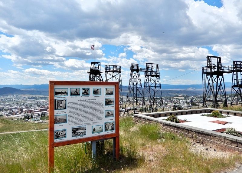
Looking south from the Butte, Anaconda & Pacific (BA&P) Hill Trail. The historic Mountain Consolidated Mine site is in the right background, and the city of Butte is downhill in the distant background.

Regionally, this marker is in andspecifically outhwest Montana, in Gold West Country, in Mining Country. It is also in the American Mountain West and in the Lewis & Clark Corridor. Globally, it is in North America, the Rocky Mountains, the Western Hemisphere, the Western World, and the Anglosphere. Historically, it finds itself in what was once Rupert’s Land and also the Louisiana Purchase.
Other nearby markers. At least 8 other markers are within walking distance of this marker: The Irish of Centerville (here, next to this marker); Cornish of Centerville (a few steps from this marker); The Con Hoist House (a few steps from this marker); The Con (within shouting distance of this marker); The Con Headframe (about 400 feet away, measured in a direct line); Welcome! To the Top of the World (about 500 feet away); St. Lawrence O’Toole Church (approx. ¼ mile away); Walkerville and the Lex (approx. 0.3 miles away). Touch for a list and map of all markers in Butte.
Also see . . . Centerville Neighborhood, Butte (Montana Historical Society).
Excerpt: Tightly clustered wooden(Submitted on August 21, 2026, by Cosmos Mariner of Cape Canaveral, Florida.)houses built into the steep slopes of the Butte Hill characterize Centerville. Mostly constructed before 1900, the small Queen Anne cottages, hipped-roof workers’ houses, and vernacular gable-roof homes primarily sheltered immigrant miners and their families. Head frames surrounded Centerville on all sides, and mining supported over three-quarters of the residents. Most homeowners leased the land upon which their houses sat from the Anaconda Company, which retained the right to reclaim the property to expand its mines. During the historic era, Centerville remained outside the city limits. As a result, the neighborhood also lacked city fire protection and street maintenance, further impeding development. Nevertheless, vibrant, ethnic strongholds developed, with cultural and occupational ties creating tightly knit communities amidst the industrial landscape.Photographed by Cosmos Mariner, July 6, 20243. Mountain Consolidated Mine SiteLooking south from the Butte, Anaconda & Pacific (BA&P) Hill Trail. The Mountain Consolidated headframe is on the left. The city of Butte is downhill in the background.

Credits. This page was last revised on August 21, 2026. It was originally submitted on August 19, 2026, by Cosmos Mariner of Cape Canaveral, Florida. This page has been viewed 13 times since then. Photos: 1, 2. submitted on August 20, 2026, by Cosmos Mariner of Cape Canaveral, Florida. 3. submitted on August 21, 2026, by Cosmos Mariner of Cape Canaveral, Florida.
