Butte in Silver Bow County, Montana — The American West (Mountains)
Montana Tech Gateway Arch

Photographed by Cosmos Mariner, July 6, 2024
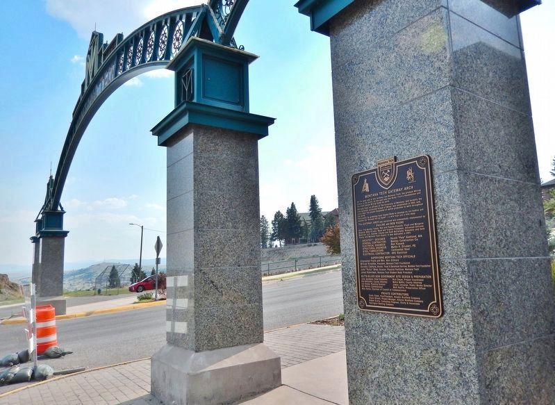
1. Montana Tech Gateway Arch Marker
On the west side of this Archway lies Montana Tech, the greatest Mining School in the world; on the east side lies Butte, Tech's Handmaiden and the most famous Mining Camp on earth.
Montana Tech, an affiliate of The University of Montana, and formerly the internationally acclaimed School of Mines, was established in 1893, and, since then, has placed thousands of skilled graduates to work throughout the world.
Particularly its graduates have helped Butte to develop its ore bodies and become the “Richest Hill on Earth” — a mile high and a mile deep.
This Gateway Arch was conceived and substantially implemented by: Pauline and Bob Poore. Also: The Bentley Family, Ron and Peachie Kissock, Floyd and Margaret Bossard, Mike O'Leary, Ward and Virginia Thompson, Advanced Silicone Materials, LLC, Andrew, Charen and Ruth McFarland, Rosemary and Herb Young, and Montana Tech Alumni. It was dedicated in 2003.
Architect/Designer: Harold “Pete” Godtland, AIA
General Contractor: Bentley Construction Co.
Electrical Engineer: Ron Kissock
Structural Engineer: Martin R. Drivdahl, PE
Steel Fabricators: Continental Steel
Electrical Contractor: ARC Electrical
Supervising
this page online
Chancellor Frank and Mrs. Ann Gilmore
William Kirschke, President, Montana Tech Foundation
Dorothy Czehura, Director, Fiscal & Operational Services, Montana Tech Foundation
John “Rollo” Shea, Director, Physical Facilities, Montana Tech
Jared Robertson, Montana Tech Student Body President
Butte-Silver Bow Government Site Design & Preparation
Judy Jacobson, Chief Executive • Bob McCarthy, County Attorney • Jon Sesso, Planning Director • Bill Melvin, Commissioner • Rich Dwyer, Project Coordinator • Mollie Maffei, County Attorney • Jimmy Johnston, Public Works Director • Mark Reavis, Preservation Officer • Mike Kerns, Chairman of Council of Commissioners
Private Contributors
Sandy Stash, Vice-President, Atlantic Richfield Company • Chuck Stilwell, Project Manager, Atlantic Richfield Company • Robert Everly, Consulting Engineer, Everly & Associates • Harrington Bottling Company
Topics. This historical marker is listed in this topic list: Education. A significant historical year for this entry is 1893.
Location. 46° 0.748′ N, 112° 33.298′ W. Marker is in Butte, Montana, in Silver Bow County. It is at the intersection of North
Photographed by Cosmos Mariner, July 6, 2024
2. Montana Tech Gateway Arch Marker
The marker is on the right/north pier of the Montana Tech Gateway Arch.

Regionally, this marker is in andspecifically outhwest Montana, in Gold West Country, in Mining Country. It is also in the American Mountain West and in the Lewis & Clark Corridor. Globally, it is in North America, the Rocky Mountains, the Western Hemisphere, the Western World, and the Anglosphere. Historically, it finds itself in what was once Rupert’s Land and also the Louisiana Purchase.
Other nearby markers. At least 8 other markers are within walking distance of this marker: Industry in the Middle (a few steps from this marker); Engineering Above and Below Ground (within shouting distance of this marker); Montana Tech Campus Gymnasium (about 500 feet away, measured in a direct line); Montana Tech Campus Residence Halls (about 500 feet away); Montana Tech Campus Engineering Building (about 600 feet away); Montana Tech Campus President's Residence

Photographed by Cosmos Mariner, July 6, 2024
3. Montana Tech Gateway Arch (east elevation)
Looking west along West Park Street. The Montana Tech Campus is uphill in the background.
Also see . . . Montana Technological University (Wikipedia).
Excerpt: The Enabling Act of 1889, which brought Montana into the Union, allotted land for the creation of a school of mines as one of the four original Montana University System universities. In 1893 the Montana Legislature provided funding to establish the school in Butte. The cornerstone of Main Hall was laid in 1896, and the university opened its doors in 1900 as the “Montana State School of Mines”. The first student was a woman, Clara Clark of Butte, and Nathan R. Leonard acted as the first president.(Submitted on August 19, 2026, by Cosmos Mariner of Cape Canaveral, Florida.)The university became affiliated with the University of Montana in 1994. After undergoing several name changes, in 2017 the Montana University System Board of Regents voted to designate Montana Tech as part of Special Focus Four-Year Universities, the only such designation in the Montana University System. To recognize this new designation and the greater independence with it, the name
was officially changed in 2018 from “Montana Tech of the University of Montana” to “Montana Technological University”. Montana Tech's focus is on engineering, applied and health science.Photographed by Cosmos Mariner, July 6, 20244. Montana Tech Gateway Arch (west elevation)Looking east along West Park Street from the Montana Tech campus. The city of Butte is in the background.

Credits. This page was last revised on August 19, 2026. It was originally submitted on August 19, 2026, by Cosmos Mariner of Cape Canaveral, Florida. This page has been viewed 23 times since then. Photos: 1, 2, 3, 4. submitted on August 19, 2026, by Cosmos Mariner of Cape Canaveral, Florida.
