Ketchikan in Ketchikan Gateway Borough, Alaska — Northwest (North America)
Historic Newtown

Photographed by Bradley Owen, August 13, 2026
1. Historic Newtown Marker
Frontier on the Frontier
You're standing on the sleek and seamless urban waterfront of Ketchikan. But in pioneer times of 1900 to 1910, this site was a rugged outpost for the industrious few - a sort of frontier on the frontier.
Between a Rock and a Harbor Place
Infant Ketchikan was hedged in by the creek on one side and an implacable rock on the other. That knob on the northwest also marked off the timeline of the First City. The town was only a few years old, but those who settled the other side of the rock called the new development Newtown.
This historical area is still defined by rock landmarks: on the southeast, Knob Hill, pierced by a tunnel, and on the northwest, the stone prominence surmounted by First Lutheran Church.
Around the Rock
"The shelf of level land upon which Newtown is located is so narrow that it disappears at points where rock heads jut out into the bay. There is so little land between meander line and mountain that pilings had to be sunk here, too, to support the buildings."
- From a history of Newtown in Tongass Historical Museum
A vital new neighborhood
Ketchikan's growth in the early 20th century was fed by commercial fishing. Its home was in Newtown.
A massive fleet of salmon and halibut boats, of fish packers and freighters, tied up in Newtown's deep harbor. Captains built fine homes above the floats. Support businesses from machinists to laundries settled on pilings along plank streets. Canneries clanked and hissed each summer. Ketchikan was the self-proclaimed Salmon Capital of the World, and cannery development after about 1910 was mostly in Newtown.
A few houses and cabins were scattered north of the rock dividing Ketchikan as the 19th century ended. In 1902, city fathers built a 10 foot-wide boardwalk around the promontory. The town and the
this page online
The community was in transition. The banking and outfitting center for mining was becoming a home for fishing families and seafood processors. A timber and mill industry arose.
Newtown was born of fishing, but by the 1930s a mature neighborhood faced the harbor - a meat market, a laundry, machinists, a tavern, a neon-sign maker, a fish-trap net fabricator, floatplane operations and others. Befitting a port town that in 1916 voted to remain "wet" and permit liquor sales, and that tolerated brothels on Creek Street, there was a - well, a special Newtown service sector. During Prohibition, Hopkins Alley was nicknamed "Home Brew Alley." Homes in the shadows allegedly doubled as speakeasies. Ketchikan residents whispered about suspected Newtown brothels. Enterprise was manifest in forms no doubt anathema to worshipers looking down from First Lutheran Church.
Faces of the Place
Newtown's early commercial buildings retain much of their character after nearly a century. Storefronts from 712 to 726 Water Street date to the 1920s and 1930s. Recessed entries and ample display windows typified the block. Wood cornices and brackets provided modest detailing. A marquee was added in the 1930s.
(Captions):
Early photographs of Ketchikan show a second waterfront developing. At far left, homes on pilings in Newtown straddle the shore and sea in 1903. A Ketchikan postcard mailed in 1909 depicts the pioneer town's division line: Knob Hill, skirted by a new pathway for walkers and horse-drawn wagons. A few businesses had opened in Newtown. A decade later, the area was a busy home for a harbor, canneries, retailers and light industry.
if you could go back in time to the mid 1930s, you would be here
A stereoscope Keystone View catches Newtown in its glory, circa 1935. Halibut and salmon fleets rest at City Float. At top right, fine homes on Captain's Hill overlook the harbor. First Lutheran Church's steeple and a freighter's mast vie for prominence. At the center left edge of the photo, a floatplane dock signals a new era in transportation. Businesses from a meat market to a garage to a fabricator of fish-trap wire net crowd along the planks of Water Street.
Members of the volunteer fire department ride a pumper truck along the commercial area of Water Street in Newtown in the 1930s. Captains Hill is in the background.
Topics.
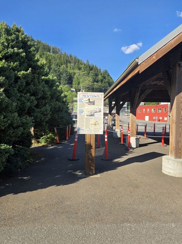
Photographed by Bradley Owen, August 13, 2026
2. Historic Newtown Marker
Location. 55° 20.669′ N, 131° 39.336′ W. Marker is in Ketchikan, Alaska, in Ketchikan Gateway Borough. It is on Schoenbar Road south of Water Street, on the right when traveling south. Touch for map. Marker is at or near this postal address: 90 Schoenbar Road, Ketchikan AK 99901, United States of America. Touch for directions.

Regionally, this marker is in Southeast Alaska, in Tlingit and Haida & Tsimshian Region. It is also on the American Pacific Coast. Globally, it is in North America, in the Inside Passage, on the Pacific Rim, in the Western Hemisphere, in the Western World, and in the Anglosphere. Historically, it finds itself in what was once the Russian Empire.
Other nearby markers. At least 8 other markers are within walking distance of this marker: Northern Machine Works (here, next to this marker); Beegle Packing Co. (here, next to this marker); Keeping the Catch! (approx. 0.3 miles away); Upon 'Thundering Wings' (approx. 0.3 miles away); From Planks to Pavement (approx. 0.3 miles away); The Easter Totem Pole (approx. 0.3 miles away); The Gilmore Hotel (approx. 0.3 miles away); Pioneer Hall (approx. 0.3 miles away). Touch for a list and map of all markers in Ketchikan.
Credits. This page was last revised on August 22, 2026. It was originally submitted on August 22, 2026, by Bradley Owen of Morgantown, West Virginia. This page has been viewed 17 times since then. Photos: 1, 2. submitted on August 22, 2026, by Bradley Owen of Morgantown, West Virginia.
