Dayton in Lyon County, Nevada — The American Mountains (Southwest)
Sutro: The Town
| — | Sutro Drainage Tunnel | — |

Friends of the Sutro Tunnel, 2026
1. Sutro: The Town Marker
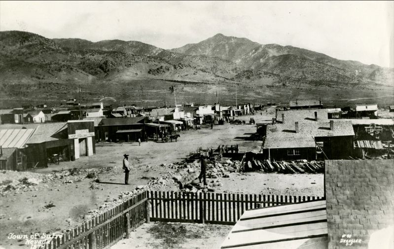
The completion of the Sutro Tunnel was the culmination of years of planning and labor - an engineering marvel of the nineteenth century-but it was not the end of Mr. Sutro's vision. The tunnel and the ore processing mills he planned to establish on the Carson River would be the economic engine for "The City of Sutro." Unlike any other mining town of the time, Sutro was to be a perfectly symmetrical town, a modern alternative to the helter-skelter mining camps clinging to mountainsides across Nevada and the West.
Under the 1866 federal "Sutro Tunnel Act," Mr. Sutro had access to vast, flat acreage at $1.25 per acre, and he planned to utilize it. He boldly told Virginia City residents that one day owls would nest in their rafters while everyone had moved to Sutro.
The town of Sutro had access to the Carson River and sat 2,000 feet lower in elevation, offering a better climate than Virginia City. Extensive agriculture was possible, and miners could easily "commute" through the tunnel - for a fee, of course. Town layout began in late 1871 and continued into 1872. Plans called for 50 numbered streets running west to
this page online
The town center would be at 27th Street (later Tunnel Avenue), 200 feet wide with sidewalks, and Florentine Street, 150 feet wide. Side streets would be 100 feet wide. For residents' benefit, Sutro mandated tree planting: deeds required at least one tree for every 25 feet of street frontage. Mr. Sutro purchased two ranches along the Carson River to produce feed for tunnel mules and to create tree farms there, introducing species not native to Nevada. No "noisy" or "dirty" businesses were allowed at the town center.
Some rentals were available, but Mr. Sutro encouraged employees to own. His sincere concern for his workers was genuine and reflected in their complete loyalty to him.
The first lot sold for $150 in 1872 - the Sutro Tunnel Company's first actual income. Water was supplied from a stone reservoir several hundred feet above the town and piped throughout. East of town, clay deposits allowed kilns to fire over 300,000 bricks in the early days. The Atmospheric Gas Company brought in a "gas"

Friends of the Sutro Tunnel, 2026
2. Sutro: The Town Marker
The future looked bright, but as the Comstock declined, workers were laid off, and income decreased. The glow dimmed; people moved away by 1882. The town limped on for another 50 years, but Adolph Sutro's dream was gone forever.
Erected 2026 by Jewish American Society for Historic Preservation.
Topics and series. This historical marker is listed in these topic lists: Industry & Commerce • Settlements & Settlers. In addition, it is included in the Jewish American Society for Historic Preservation. series list.
Location. 39° 16.735′ N, 119° 34.986′ W. Marker is in Dayton, Nevada, in Lyon County. It is on Sutro Tunnel Road. Touch for map. Marker is in this post office area: Dayton NV 89403, United States of America. Touch for directions.

Regionally, this marker is in the Sierra Nevada and in Greater Reno Area. It is also in the American Mountain West. Globally, it is in North America,

Friends of the Sutro Tunnel, 2026
3. Sutro Tunnel - historic site map
Other nearby markers. At least 8 other markers are within 3 miles of this marker, measured as the crow flies: The Mill (about 300 feet away, measured in a direct line); The Mule Barn (about 300 feet away); The Sutro Tunnel - Machine Shop (about 400 feet away); Sutro Tunnel (about 500 feet away); The Mansion (approx. 0.2 miles away); Sutro (approx. one mile away); Lifeblood of the Mills (approx. 2.7 miles away); Camels in Dayton (approx. 2.8 miles away). Touch for a list and map of all markers in Dayton.
Also see . . .
1. Creators share their morning routines Creators share their morning routines The 4-Mile Tunnel That D. Deep in the Nevada desert sits one of the most ambitious engineering projects of the 1800s...a tunnel nearly 4 miles long, carved straight through a mountain to reach the richest silver mines in American history. At the height of the Comstock Lode, miners were battling extreme heat, deadly gases, and flooding miles underground. After a catastrophic
2. Sutro, Nevada (Wikipedia). (Submitted on September 25, 2026.)
Credits. This page was last revised on September 25, 2026. It was originally submitted on August 31, 2026, by Jerry Klinger of Boynton Beach, Florida. This page has been viewed 12 times since then. Photos: 1, 2, 3. submitted on August 31, 2026, by Jerry Klinger of Boynton Beach, Florida. 4. submitted on September 25, 2026. • Andrew Ruppenstein was the editor who published this page.
