Ouderkerk aan de Amstel in Ouder-Amstel, North Holland, Netherlands — Northwestern Europe
Kerkbrug/Korte brug
⎯⎯⎯
“Church Bridge”/“Short Bridge”
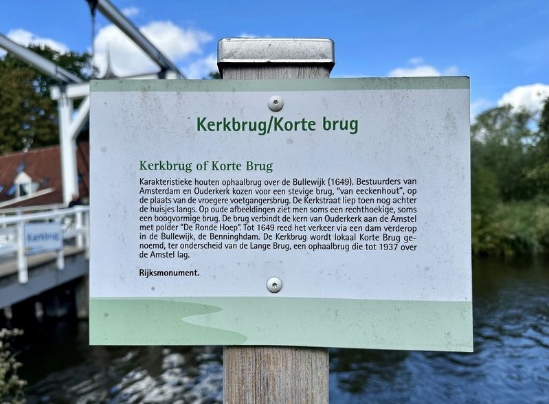
Photographed by Andrew Ruppenstein, September 1, 2026
1. Kerkbrug/Korte brug / Church Bridge/Short Bridge Marker

Karakteristieke houten ophaalbrug over de Bullewijk (1649). Bestuurders van Amsterdam en Ouderkerk kozen voor een stevige brug, "van eeckenhout", op de plaats van de vroegere voetgangersbrug. De Kerkstraat liep toen nog achter de huisjes langs. Op oude afbeeldingen ziet men soms een rechthoekige, soms een boogvormige brug. De brug verbindt de kern van Ouderkerk aan de Amstel met polder "De Ronde Hoep". Tot 1649 reed het verkeer via een dam verderop in de Bullewijk, de Benninghdam. De Kerkbrug wordt lokaal Korte Brug ge- noemd, ter onderscheid van de Lange Brug, een ophaalbrug die tot 1937 over de Amstel lag.
Rijksmonument.
Kerkbrug or Korte Brug
Characteristic wooden drawbridge over the Bullewijk (1649). Administrators of Amsterdam and Ouderkerk opted for a sturdy bridge, "of oak wood", at the site of the former pedestrian bridge. At that time, Kerkstraat still ran behind the houses. In old images, one sometimes sees a rectangular bridge, sometimes an arched one. The bridge connects the center of Ouderkerk aan de Amstel with the "De Ronde Hoep" polder.
this page online
National Monument.
Topics. This historical marker is listed in this topic list: Bridges & Viaducts. A significant historical year for this entry is 1649.
Location. 52° 17.7′ N, 4° 54.128′ E. Marker is in Ouderkerk aan de Amstel, Noord-Holland (North Holland), in Ouder-Amstel. It is at the intersection of Rondehoep Oost and Achterdijk, on the right when traveling west on Rondehoep Oost. Touch for map. Marker is at or near this postal address: Achterdijk 2, Ouderkerk aan de Amstel, Noord-Holland 1191 JB, Netherlands. Touch for directions.

Regionally, it is in Europe, the European Union, Atlantic Europe, the Benelux Low Countries, the Schengen Area, Western Europe, and the Western World. Historically, it finds itself in what was once the Holy Roman Empire.
Other nearby markers. At least 8 other markers are within walking distance of this marker: Sint Urbanuskerk / St. Urbanus Church

Photographed by Andrew Ruppenstein, September 1, 2026
2. Kerkbrug/Korte brug / “Church Bridge”/“Short Bridge” and Marker
Also see . . . Kerkbrug (Ouderkerk aan de Amstel) (Wikipedia, in Dutch). (Submitted on September 1, 2026.)

Photographed by Andrew Ruppenstein, September 1, 2026
3. Kerkbrug/Korte brug

Photographed by Andrew Ruppenstein, September 1, 2026
4. Kerkbrug/Korte brug
The Kerkbrug is a wooden drawbridge in the center of the North Holland village of Ouderkerk aan de Amstel and spans the Bullewijk. The bridge connects Kerkstraat in the village center with Ronde Hoep-oost, and after the bridge, Kerkstraat transitions into Achterdijk. The bridge has stood there in virtually unchanged form since 1649 and is a National Monument (number 31977). - Wikipedia (in translation)
Credits. This page was last revised on September 1, 2026. It was originally submitted on September 1, 2026, by Andrew Ruppenstein of Lamorinda, California. This page has been viewed 11 times since then. Photos: 1, 2, 3, 4. submitted on September 1, 2026, by Andrew Ruppenstein of Lamorinda, California.
