Near Bardstown in Nelson County, Kentucky — The American South (East South Central)
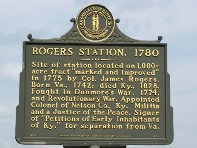
Rogers Station, 1780
Erected 2000 by Kentucky Historical Society / Kentucky Department of Highways. (Marker Number 820.)
Topics and series. This historical marker is listed in these topic lists: Political Subdivisions • Settlements & Settlers • War, US Revolutionary. In addition, it is included in the Kentucky Historical Society series list. A significant historical year for this entry is 1775.
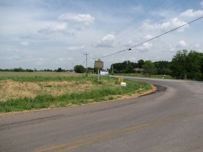
Location. 37° 48.648′ N, 85° 32.061′ W. Marker is near Bardstown, Kentucky, in Nelson County. Marker is at the intersection of Boston Road (U.S. 62) and Airport Road (State Road 2737), on the right when traveling west on Boston Road. Touch for map. Marker is in this post office area: Bardstown KY 40004, United States of America. Touch for directions.
Other nearby markers. At least 8 other markers are within 4 miles of this marker, measured as the crow flies. Cedar Creek Baptist (approx. half a mile away); The First Cedar Creek Baptist Church (approx. one mile away); Rowan-Chambers Duel (approx. 3.1 miles away); Saint Joseph Cathedral / Diocese of Bardstown (approx. 3.4 miles away); Edgewood (approx. 3˝ miles away); Bethlehem Academy (approx. 3˝ miles away); Spalding Hall (approx. 3˝ miles away); Saint Thomas Farm (approx. 3˝ miles away). Touch for a list and map of all markers in Bardstown.
Regarding Rogers Station, 1780. Colonel James Rogers was also instrumental in the founding of the First Cedar Creek Baptist Church, as described by the "Cedar Creek Baptist" marker located approximately 1/2-mile West of this marker.
Additional commentary.
1. I married Lisa Rogers in June of 1980. She is the daughter of Edward Rogers
Edward Rogers was the G.G.G.G. grandson of John Rogers architect and one of the organizers and founders of St. Josephs Cathedral in Bardstown, Ky. Edwards wife was Lois Young Rogers. The Youngs were original charter members of Cedar Creek Baptist Church in Nelson Co., Ky. Edward and Lois built their home less than 1/3 mile from Rogers Station at the entrance to Hubbards Ln. After spending many years tramping over all the land (plus much more) that encompassed Rogers station by foot and being somewhat
of an amateur archaeologist, I can say without a doubt that I know the 'exact' location of the stockade. As late as the 1970's the logs and timbers that were used in the construction of the defense wall and various blockhouses, cabins, etc. could still be found and seen where the farmer who owned the land at the time in the 1950's, had pushed them over the hill and into the spring below the stockade entrance in order to clear more land for planting. There are at this time to date still growing, alive and well, 2 very large and old oak trees of sufficient size and age that it would be reasonable to believe that they were planted there by the builders of the stockade as shade trees, one on each side of its entrance where the road passed through the gates. The road that lead to the forts entrance can still be easily seen and walked. I don't know if this is common knowledge around there or not, but at least now someone knows that this spot is known.
— Submitted December 9, 2011, by Alan H. Woodring of Winchester, Ky..
Credits. This page was last revised on June 16, 2016. It was originally submitted on May 21, 2010, by Lee Hattabaugh of Capshaw, Alabama. This page has been viewed 2,643 times since then and 99 times this year. Photos: 1, 2. submitted on May 21, 2010, by Lee Hattabaugh of Capshaw, Alabama. • Craig Swain was the editor who published this page.

