Southampton in Richboro in Bucks County, Pennsylvania — The American Northeast (Mid-Atlantic)
From Public Highway to Scenic Byway ...

Photographed by Richard Peterson, September 7, 2026
1. From Public Highway to Scenic Byway ... Marker
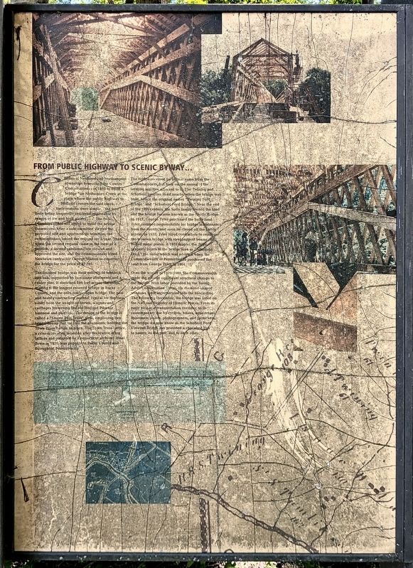
The finished bridge was built entirely of hemlock and oak, supported by two stone abutments and a center pier. It stretched 166 feet across the creek, making it the longest covered bridge in Bucks County and the only double span bridge. The post and beam construction method, typical tor the time, easily bore the weight of horses, wagons and carriages traversing the old Holland Pike for business and
this page online
The bridge received no formal name from the Commissioners, but took on the names of the farming families adjacent to it. The Twining and Schofield families lived nearby when the bridge was built, hence the original names “Twining Ford Bridge” and “Schofield Ford Bridge.” Near the end of the 19th century, the Solly family owned the land and the bridge became known as the “Solly Bridge.” In 1917, George Tyler purchased the Solly land. Tyler assumed responsibility for bridge maintenance from the county and soon he closed off the public access. In 1932, Tyler hired contractors to reinforce the wooden bridge with steel support beams and bolted metal plates. A 1931 map of the Tyler property refers to the bridge area as “Schofield Ford,” the name which was adopted when the

Photographed by Richard Peterson, September 7, 2026
2. Schofield Ford Covered Bridge, group of four Markers at right
Over the winter of 1979/1980, the Commonwealth made the second significant structural change to the bridge. With labor provided by the Young Adult Conservation Corps, six diamond-shaped windows were incorporated into the new siding. The following December, the bridge was listed on the National Register of Historic Places. From its early role as a transportation corridor, to its contemporary use by cyclists, hikers, equestrians, fishermen, artists, photographers, and picnickers, the bridge we now know as the Schofield Ford Covered Bridge has provided a cherished link to nature, to the past, and to each other.
Topics. This historical marker is listed in this topic list: Bridges & Viaducts. A significant historical year for this entry is 1869.
Location. 40° 14.633′ N, 74° 58.867′ W. Marker is in Richboro, Pennsylvania, in Bucks County. It is in Southampton. It can be reached from Swamp Road 0.7 miles east of Worthington Mill Road. Marker is in Tyler State Park. It is on the Covered Bridge Trail, 0.2 miles from parking area which is 0.2 mile from Swamp Road. Touch for map.

Photographed by Richard Peterson, July 18, 2005
3. Schofield Ford Covered Bridge

Regionally, this marker is in Southeast Pennsylvania and in Greater Philadelphia. It is also in the American Northeast and in the Mid-Atlantic. Globally, it is in North America, the Western Hemisphere, the Western World, and the Anglosphere. Historically, it finds itself in what was once the Haudenosaunee (Iroquois) Confederacy, New Netherland, and one of the original Thirteen Colonies.
Other nearby markers. At least 8 other markers are within walking distance of this marker: From Loss to Renewal ... (here, next to this marker); A Bridge from Past to Present, Neighbor to Neighbor ... (a few steps from this marker); The Schofield Ford Covered Bridge (about 300 feet away, measured in a direct line); Community-built Landmark (about 300 feet away); Bridging Past and Present (about 300 feet away); Summer House Garden Seat (approx. 0.7 miles away); The Sculptures of Stella Elkins Tyler (approx. ¾ mile away); Tyler Gardens Planting Area (approx. ¾ mile away).
Photographed by Richard Peterson, September 7, 2026
4. From Public Highway to Scenic Byway ... Marker
Credits. This page was last revised on September 21, 2026. It was originally submitted on September 12, 2026, by Richard Peterson of East Windsor, New Jersey. This page has been viewed 5 times since then. Photos: 1, 2, 3, 4. submitted on September 12, 2026, by Richard Peterson of East Windsor, New Jersey. • Bill Pfingsten was the editor who published this page.
