Berliner Innenstadt in Friedrichshain-Kreuzberg, Germany — Northeast German Plain (The European Plain)
Wilhelmstraße 106
| — | Geschichtsmeile Wilhelmstraße / Wilhelmstraße History Mile | — |
Photographed by James Hulse, March 6, 2026
1. Wilhelmstraße 106 Marker

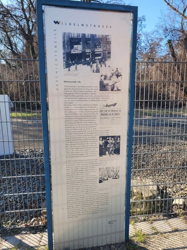
Der Verlag mietete 1933 im Nachbarhaus Wilhelmstraße 107 zusätzliche Räume an und ließ beide Häuser durch einen direkten Zugang verbinden. Ein Jahr später ging er in Konkurs. Die Zeitung bestand weiter, ihre Redaktion zog in die Zimmerstraße. Die nächsten vier Jahre wurde das Gebäude von der Sturmabteilung (SA) genutzt. Die von Ernst Röhm geführte SA entstand 1920 als paramilitärische Schutztruppe der NSDAP. Zu ihren Aufgaben gehörten bereits vor 1933 die Absicherung von Parteiveranstaltungen und die Terrorisierung politischer Gegner. Auf Röhms Forderung, die SA zur Volksarmee zu machen, reagierte Hitler 1934 mit der Ermordung eines Drittels der höheren SA-Führerschaft. Zum Nachfolger Röhms ernannte er Viktor
this page online
1937 übernahm der im benachbarten Prinz-Albrecht-Palais ansässige Sicherheitsdienst der SS (SD) das Haus, unter dem er eine Tiefgarage errichten ließ. Das im Zweiten Weltkrieg stark beschädigte Gebäude wurde in den 1950er Jahren abgerissen. In den 1980er Jahren befand sich auf dem Grundstück ein privater Verkehrsübungsplatz. Heute ist es Teil des Dokumentationszentrums Topographie des Terrors.
Das Redaktionsgebäude des »Angriff«, 1934, Bildarchiv Preußischer Kulturbesitz, Berlin
Chefredakteur Dr. Julius Lippert (links) während einer Redaktionssitzung, 1932, Landesarchiv Berlin
Titelseite des »Angriff«, 30. Juni 1934, Landesarchiv Berlin
SA-Stabschef Viktor Lutze verläßt das Gebäude Wilhelmstraße 106, 24. Juli 1934, SV-Bilderdienst, München
Das Autodrom. Verkehrsübungsplatz, um 1980, Landesarchiv Berlin
Photographed by James Hulse, March 6, 2026
2. Wilhelmstraße 106 Marker
In 1933 the publishing house rented extra space next door at Wilhelmstraße 107 and built a passage connecting the two buildings. It went bankrupt the following year, but the newspaper continued printing and the editorial staff moved to Zimmerstraße. For the next four years the building was used by the SA (Storm Troopers). Led by Ernst Röhm, the SA was set up in 1920 as a Nazi Party paramilitary protection squad. Even before Hitler took power in 1933 it organized security for Nazi Party events and terrorized political opponents. In 1934, in reaction to Röhm’s demand that the SA become a people’s army, Hitler had one-third of the top SA leadership murdered. In July 1934, Viktor Lutze, appointed by Hitler as Röhm’s successor, moved into Wilhelmstraße 106 with his personal staff for several months. The building then became the headquarters of the SA leadership in the Berlin-Brandenburg region. In 1937 the SS Security Service (SD), which was based next door in Prinz Albrecht Palais, took over the building and added an underground garage.
The building was badly damaged in the Second World War and demolished in the 1950s. In the 1980s there was a private driving practice area on the site. Today it is part of the Topography of Terror Documentation Center.
“Der Angriff” editorial office building, 1934, Bildarchiv Preußischer Kulturbesitz, Berlin
Editor-in-chief Dr. Julius Lippert (left) at an editorial meeting, 1932, Landesarchiv Berlin
Front page of “Der Angriff”, June 30, 1934, Landesarchiv Berlin
Viktor Lutze, SA chief of staff, leaving Wilhelmstraße 106, July 24, 1934, SV-Bilderdienst, München
Driving practice area, ca. 1980, Landesarchiv Berlin
Erected by Topographie des Terrors and Designer, Helga Lieser.
Topics. This historical marker is listed in these topic lists: Notable Buildings • War, World II. A significant historical date for this entry is June 30, 1934.
Location. 52° 30.34′ N, 13° 23.176′ E. Marker is in Berlin, in Friedrichshain-Kreuzberg. It is in Berliner Innenstadt. It is at the intersection of Wilhelmstraße and Anhalter Str., on the left when traveling north on Wilhelmstraße. Touch for map. Marker is at or near this postal address: Wilhelmstraße 106, Berlin 10963, Germany. Touch for directions.

Regionally, it is in Europe, the European Union, Atlantic Europe, Central Europe, the Schengen Area, Western Europe, and the Western World. Historically, it finds itself in what was once the Holy Roman Empire, the former West Germany, and at the Berlin Wall.
Other nearby markers. At least 8 other markers are within walking distance of this marker: Wilhelmstraße 102 (about 90 meters away, measured in a direct line); History of Berlin’s Government Quarter (about 90 meters away); Prinz-Albrecht-Palais / Prinz Albrecht Palais (about 120 meters away); Europahaus-Komplex / Europahaus Complex (about 150 meters away); Dienststellen von Gestapo und SS / Gestapo and SS Offices (about 150 meters away); NS-Luftschutzbauten / Nazi Air Raid Protection Structures (about 150 meters away); Verpflegungsbaracke der SS / SS Mess Hut (about 150 meters away); Prinz-Albrecht-Gelände (about 150 meters away). Touch for a list and map of all markers in Berlin.
Credits. This page was last revised on September 14, 2026. It was originally submitted on September 13, 2026, by James Hulse of Medina, Texas. This page has been viewed 12 times since then. Photos: 1, 2. submitted on September 14, 2026, by James Hulse of Medina, Texas.
