Seattle Waterfront in King County, Washington — The American West (Northwest)
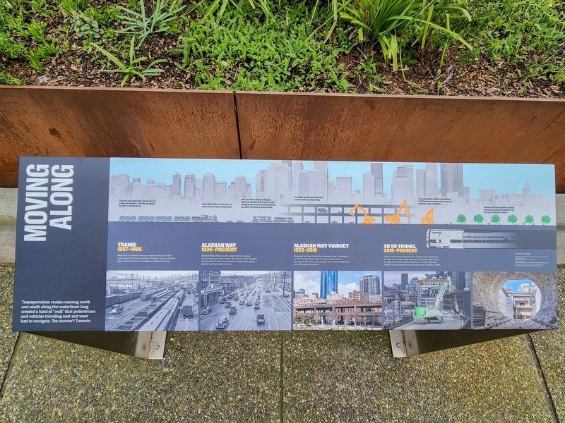
Moving Along
Photographed by Douglass Halvorsen, February 20, 2026
1. Moving Along Marker
Trains 1887-1986
Nine sets of railroad tracks on trestles over sea water once spanned the area between Western Avenue and the piers, forming noisy and dangerous Railroad Avenue.
Train cars were pushed right onto the piers for loading and unloading. Until 1906, passenger boarded at trackside depots.
Alaskan Way 1936-Present
Alaskan Way offered north-south traffic a bypass around the core of downtown. But almost from the start, its popularity further congested the waterfront, giving planners a new puzzle to solve.
When Alaskan Way was first built, cars drove next to the trains, along the piers.
Some train traffic continued along the waterfront until 1986 when it was all routed through the tunnel that runs under downtown from below Pike Street to Jackson Street.
Alaskan Way Viaduct 1953-2019
Designed to divert traffic from Alaskan Way, the viaduct cut off the waterfront from the rest of downtown—although it did offer
this page online
The viaduct was built after World War II to divert traffic from Alaskan Way.
SR 99 Tunnel 2019-Present
Today, north-south vehicle traffic moves under downtown through a two-mile tunnel, opened in 2017, that was bored by a giant machine dubbed “Bertha” in honor of Bertha Knight Landes, Seattle’s first female mayor, elected in 1926.
The double-decker viaduct was demolished in 2019 because of concerns that it would not withstand a major earthquake.
Waterfront Park makes Seattle’s shoreline accessible and pedestrian-friendly for the first time in more than a century.
Topics. This historical marker is listed in these topic lists: Bridges & Viaducts • Industry & Commerce • Railroads & Streetcars. A significant historical year for this entry is 1887.
Location. 47° 36.292′ N, 122° 20.371′ W. Marker is in Seattle, Washington, in King County. It is in Seattle Waterfront. It can be reached from Alaskan Way. Touch for map. Marker is at or near this postal address: 1101 Alaskan Wy, Seattle WA 98104, United States of America. Touch for directions.

Regionally, this
Photographed by Douglass Halvorsen, February 20, 2026
2. Moving Along Marker
Other nearby markers. At least 8 other markers are within walking distance of this marker: Elliott Bay (within shouting distance of this marker); Grand Pacific Hotel (about 600 feet away, measured in a direct line); Colonial Hotel (about 600 feet away); Colman Building (about 600 feet away); Beebe Building (about 700 feet away); Alexis Hotel / Globe Building (about 700 feet away); The Holyoke Building (about 700 feet away); Start of Seattle Fire Site (approx. 0.2 miles away). Touch for a list and map of all markers in Seattle.
Another marker is no longer nearby. ‘Miike Maru’ (was approx. 0.2 miles away but has been permanently removed).
Photographed by Douglass Halvorsen, February 20, 2026
3. Moving Along Marker
Credits. This page was last revised on September 15, 2026. It was originally submitted on September 14, 2026, by Douglass Halvorsen of Klamath Falls, Oregon. This page has been viewed 5 times since then. Photos: 1, 2, 3. submitted on September 14, 2026, by Douglass Halvorsen of Klamath Falls, Oregon. • Andrew Ruppenstein was the editor who published this page.
