Silchester in Hampshire, England, United Kingdom — Northwestern Europe (the British Isles)
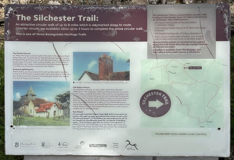
The Silchester Trail
Photographed by Ray Gurganus, May 21, 2026
1. The Silchester Trail Marker
The Parish Church
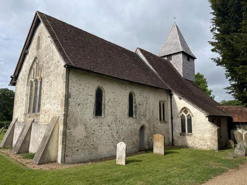
St. Mary the Virgin was first built in the mid-12th century. Much earlier this was a sacred site for the Roman townspeople, as two temples lie beneath the Church and the churchyard. Do take time to go inside. The early 16th century screen, one of the best in Hampshire, was hidden in the times of the Reformation and the Civil War, but found and restored in the 1860's.
Roman Amphitheatre
After visiting the Church proceed north up the road to see the, remains of the Roman amphitheatre. You will be able to return to the route by passing through the kissing gate beside the road to the rear of Manor Farm House.
Old Manor House
The Old Manor House, on your right, dates from the late 16h/early 17th centuries. Evidence of the existence of a much earlier house, possibly from the 13th century, is indicated by an entrance to the Church being on the north side and the blocked-up door
this page online
Rye House
As you walk round the Roman Town Wall, before you reach the path to the main car park, you will see Rye House to your right. The present house in 17th century, but was built on the site of the hospice or convalescent home for the Monks of Reading Abbey. They would be sent here to recover from illnesses or perhaps to die. It is not known why the Monks chose this site, but material from the Roman Town was used in the building of Reading Abbey, founded by Henry I in 1121.
The Silchester Trail is a waymarked, circular walk leading to the Roman Town of Calleva Atrebatum at Silchester. This Trail features:
• Alternative start points at Bramley Station or Silchester village.
• 12th Century Parish Church of St. Mary the Virgin, Silchester.
• The English Heritage site of Calleva Atrebatum.
•
Photographed by Ray Gurganus, May 21, 2026
2. Church of St Mary the Virgin
Interpretation panels are located at key points along the trail which describe the various features of interest en route.
A Leaflet is available from The Bramley, and The Calleva Arms public house in Silchester.
Erected by Hampshire County Council.
Topics. This historical marker is listed in these topic lists: Notable Places • Religion & Religious Structures.
Location. 51° 21.382′ N, 1° 4.632′ W. Marker is in Silchester, England, in Hampshire. It is on Church Lane. The marker is located by the exterior wall of the graveyard of St Mary the Virgin church. Touch for map. Marker is at or near this postal address: 178 Church Lane, Silchester, England RG7 2HH, United Kingdom. Touch for directions.

Regionally, this marker is in the Greater South East. Globally, it is on the Atlantic Ocean, in the North Atlantic Region, in Europe, in Atlantic Europe, on one of the British Isles, in the Western World, and in the Anglosphere. Historically, it finds itself in what was once the Roman Empire.
Other nearby markers. At least 8 other markers are within 11 kilometers of this marker, measured as the crow flies: Calleva Atrebatum - A Roman Town (here, next to this marker); Welcome to the Holy Ghost Cemetery (approx. 9.6 kilometers away); Holy Ghost Cemetery (approx. 9.7 kilometers away); a different marker also named Welcome to the Holy Ghost Cemetery (approx. 9.8 kilometers away); The Basing Trail (approx. 9.8 kilometers away); Methodist Church (approx. 10.2 kilometers away); Remembrance Garden (approx. 10.2 kilometers away); John Curwen (approx. 10.5 kilometers away).
Credits. This page was last revised on September 15, 2026. It was originally submitted on September 15, 2026, by Ray Gurganus of Washington, District of Columbia. This page has been viewed 5 times since then. Photos: 1, 2. submitted on September 15, 2026, by Ray Gurganus of Washington, District of Columbia. • Andrew Ruppenstein was the editor who published this page.
