Berkswell in West Midlands, England, United Kingdom — Northwestern Europe (the British Isles)
Berkswell
Information
Photographed by Ray Gurganus, May 25, 2026
1. Berkswell Marker
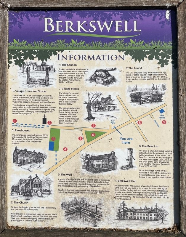
1. Berkswell Hall
Visible from the Millennium Way after it leaves the Church yard, this Hall was built in its present form in 1814 by Sir John Eardley Eardley Wilmot. Now the hall and stables are private apartments although the surrounding land is still owned by the Berkswell Estate. The park at Berkswell was granted by Henry I to the Earl of Warwick around 1120 as hunting ground.
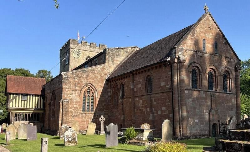
2. The Church
St. John the Baptist goes back to the 12th century and has a vibrant community. Near the gate is the ancient base, perhaps of Saxon origin, which now holds a cross. The shaft and head have been renovated copying the head found by gravediggers in the mid-19th century.
3. The Well
A group of springs at the end of Church Lane is the source of water for this well which has provided abundant clean water from time immemorial. It is possibly the reason for the initial settlement and naming of Berkswell. Nearby is The Well House which was formerly the Rectory, built in its present form between 1711 and 1722.
4. The Cannon
Tucked behind the Almshouses in the allotment area is the cannon captured from the Russians at Kerch in
this page online
5. Almshouses
The Almshouses were built around 1853 and comprise 12 dwellings. They replaced 12 cottages demolished after their occupants died of an unspecified epidemic.
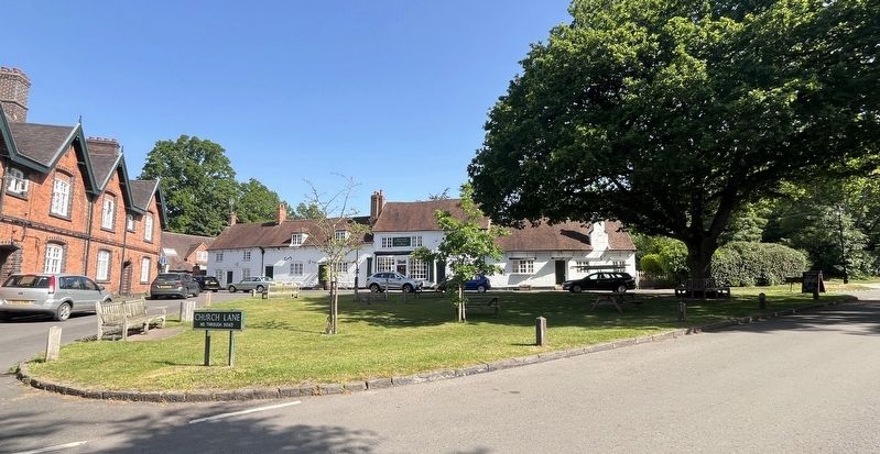
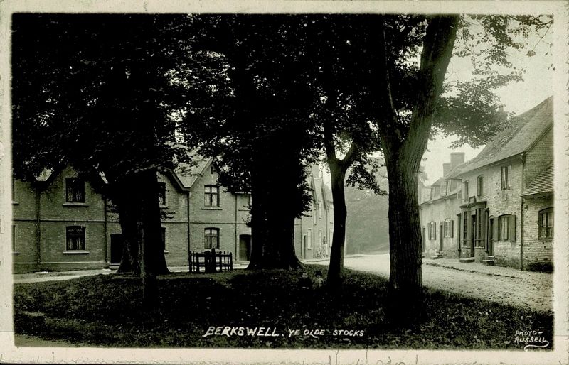
6. Village Green and Stocks
The stocks are set on the Village Green in the centre of Berkswell. These were used until the mid 19th century for the punishment of vagabonds, beggars, drunkards and blasphemers The stocks are unusual having 5 not 4 limb spaces. After school most days Berkswell children can be seen using the immemorial right to "play lawful games" and enjoy the village green for recreational purposes.
7. Village Stores
The Village Stores and Tearoom is reputed to be one of the oldest shops in Warwickshire and is still open for business today. The cottage adjacent to the shop has a cruck frame dating perhaps between 1450 and 1500; it is the oldest house in the Berkswell parish that has so far been recognised.
8. The Bear Inn
The Bear is a Grade II listed building dating back to the sixteenth century. While we do not know when the Bear first became an Inn,
Photographed by Ray Gurganus, May 25, 2026
2. Church of St John the Baptist
9. The Pound
This was the place stray animals such as pigs, sheep or cattle could be kept until claimed by their owners for the payment of a fine or levy. It was used as recently as 2013 for 3 abandoned ponies.
Topics. This historical marker is listed in these topic lists: Industry & Commerce • Notable Places • Religion & Religious Structures. A significant historical year for this entry is 1814.
Location. 52° 24.568′ N, 1° 38.436′ W. Marker is in Berkswell, England, in West Midlands. It is at the intersection of Church Lane and Lavender Hall Lane, on the right when traveling west on Church Lane. Touch for map. Marker is at or near this postal address: 10 Church Lane, Berkswell, England CV7 7BJ, United Kingdom. Touch for directions.

Regionally, this marker is in England’s Midlands. Globally, it is on the Atlantic Ocean, in the North Atlantic Region,
Photographed by Ray Gurganus, May 25, 2026
3. Berkswell Village Green
Other nearby markers. At least 8 other markers are within 10 kilometers of this marker, measured as the crow flies: The Quadrant (approx. 8.7 kilometers away); Angela Brazil (approx. 8.7 kilometers away); William Bawden's Coventry, 1919 (approx. 8.7 kilometers away); Grey Friars Gate (approx. 8.7 kilometers away); Christchurch Spire (approx. 8.8 kilometers away); Dresden Place (approx. 8.8 kilometers away); Dame Ellen Terry (approx. 8.8 kilometers away); The Architect’s Vision (approx. 8.8 kilometers away).
Photographed by Photo-Russell, circa 1928
4. Ye Olde Stocks (mentioned on the marker)
This was taken about 10 meters west of the marker.
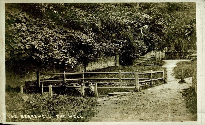
circa 1928
5. The Well (mentioned on the marker)
Credits. This page was last revised on September 16, 2026. It was originally submitted on September 15, 2026, by Ray Gurganus of Washington, District of Columbia. This page has been viewed 7 times since then. Photos: 1, 2, 3. submitted on September 15, 2026, by Ray Gurganus of Washington, District of Columbia. 4, 5. submitted on September 16, 2026. • Andrew Ruppenstein was the editor who published this page.
