Near Lucerne in Fraser-Fort George, British Columbia — Canada’s West Coast (North America)
Rails Through the Rockies/Des rails à travers les Rocheuses

Photographed by Cosmos Mariner, July 6, 2022
1. Rails Through the Rockies/Des rails à travers les Rocheuses Marker

Between 1906 and 1915, both the Grand Trunk Pacific and Canadian Northern Railways built rail lines through Yellowhead Pass. The high level of traffic expected never materialized and both railways ran into financial difficulty shortly after the outbreak of World War I. The two routes were merged into the Canadian National Railway after only a few years of operation. Rails were removed from the abandoned sections and shipped east in 1917 for the war effort.
Lucerne
In 1913, the town of Lucerne, located on Yellowhead Lake, was a main
this page online
De 1906 à 1915, le Grand Trunk Pacific et le Chemin de fer Canadien du Nord construisirent tous deux des voies ferrées dans le col Yellowhead. L'important trafic attendu ne se matérialisa jamais, et les deux sociétés
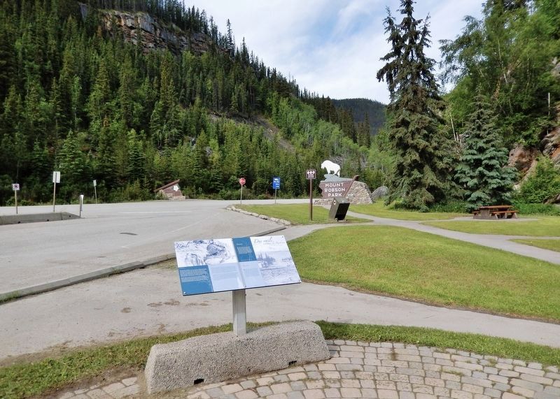
Photographed by Cosmos Mariner, July 6, 2022
2. Rails Through the Rockies/Des rails à travers les Rocheuses Marker
Looking west along Yellowhead Highway (Provincial Highway 16) from the Portal Lake Rest Area.
Lucerne
En 1913, le hameau de Lucerne, situé au là bord du lac Yellowhead, était un important centre divisionnaire pour le Chemin de fer Canadien du Nord. Lorsque les deux sociétés ferroviaires fusionnèrent, Fitzhugh (rebaptisée plus tard Jasper) prit le rôle de gare principale et Lucerne devint excédentaire. Les employés du Chemin de fer Canadien du Nord qui conservèrent leur emploi durent se réinstaller à Fitzhugh, qui, du coup, doubla sa population grâce à l'arrivée de ces nouveaux résidents.
Erected by Parks Canada/Parcs Canada.
Topics. This historical marker is listed in these topic lists: Railroads & Streetcars • Settlements & Settlers.
Location. 52° 52.925′ N, 118° 27.08′ W. Marker is near Lucerne, British Columbia, in Fraser-Fort George. It is on Yellowhead Highway (Provincial Highway 16) 24.8 kilometers west of Icefields Parkway (Provincial Highway 93), on the right when traveling west. The marker is at the Yellowhead Pass National Historic Site in Mount Robson Provincial Park, just west of the British Columbia-Alberta boundary line. Touch for map. Marker is in this post office area: Lucerne BC V0E 2Z0, Canada. Touch for directions.

Regionally, this marker is in the BC Interior and in Cariboo Chilcotin Coast. Globally, it is in North America, on the Ring of Fire, on the Pacific Rim, in the Western Hemisphere, in the Western World, and in the Anglosphere. Historically, it finds itself in what was once a British colony.
Other nearby markers. At least 8 other markers are within walking distance of this marker: Welcome to Yellowhead Pass National Historic Site (here, next to this marker); Crossing the Great Divide/Traverser la ligne de partage des eaux (here, next to this marker); Travelling a Traditional Route/Parcourir une route traditionnelle (a few steps from this marker); The Yellowhead Pass / Le col Tête-Jaune (a few steps from this marker); Modern Travel/Les voyages des temps modernes (a few steps from this marker); Connecting Canada/D'un océan à l'autre (a few steps from this marker); Historic Yellowhead Pass (a few steps from this marker); Yellowhead Pass (a few steps from this marker). Touch for a list and map of all markers in Lucerne.
Also see . . . Lucerne, British Columbia (SpiralRoad.com).
Excerpt: The Canadian Northern Railway (CNoR) built their station at Lucerne on the south side of Yellowhead Lake by 1913. The Grand Trunk Pacific Railway (GTR) had laid its track north of the lake the year before. Lucerne was a divisional point on the CNoR and provided the nucleus of a town. After the two railroads were nationalized in 1921, Jasper was chosen as the divisional point of the new Canadian National Railway. At the time both towns had populations approaching 300. By the end of 1924 almost everyone had moved to Jasper, the rails of the yard had been taken up, and Lucerne became a whistle stop on the Canadian National line. The Lucerne railway station, as big as the Jasper station, was demolished after World War II.(Submitted on September 24, 2026, by Cosmos Mariner of Cape Canaveral, Florida.)During the Second World War, about 100 Japanese nationals were interned at camps at Lucerne, Rainbow, Moose River, Fitzwilliam, and Red Pass. As forced labor, they cleared a new right-of-way on sections of the Yellowhead Highway.
The Lucerne Station post office was open from 1914 to 1926; less than ten cancellation marks are known in collections. A post office was also open at Lucerne from 1942 to 1945; no cancellation marks between those dates are known to exist.
Credits. This page was last revised on September 24, 2026. It was originally submitted on September 23, 2026, by Cosmos Mariner of Cape Canaveral, Florida. This page has been viewed 9 times since then. Photos: 1, 2. submitted on September 24, 2026, by Cosmos Mariner of Cape Canaveral, Florida.
