
St Katharine's & Wapping in Tower Hamlets in Greater London, England, United Kingdom — Northwestern Europe (the British Isles)
Roman City Wall
Discover the Fortress Story
Photographed by Ian Lefkowitz, September 11, 2026
1. Roman City Wall Marker

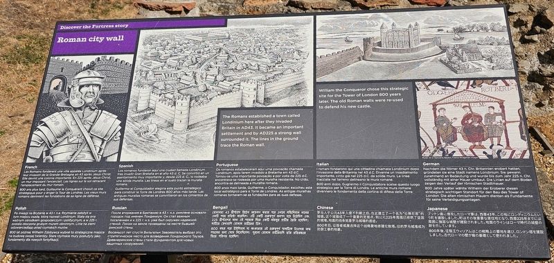
The Romans established a town called Londinium here after they invaded Britain in AD43. It became an important settlement and by AD225 a strong wall surrounded it. The lines in the ground trace the Roman wall.
William the Conqueror chose this strategic site for the Tower of London 800 years later. The old Roman walls were re-used to defend his new castle.
Les Romains fondèrent une ville appelée Londinium après leur invasion de la Grande-Bretagne en 43 après Jésus-Christ. Elle devint une colonie importante. En 225 après Jésus-Christ, un mur imposant l’encerclait. Les lignes sur le sol retracent l’emplacement du mur romain.
800 ans plus tard, Guillaume le Conquérant choisit ce site stratégique pour y ériger la Tour de Londres. Les vieux murs romains devinrent les fondations de sa ligne de défense.
Los romanos fundaron aquí una ciudad llamada Londinium un tras invadir Gran Bretaña en el año 43 d.C. Se convirtió en un asentamiento muy importante y, desde 225 d.C, lo rodeaba una sólida muralla. Las líneas en el suelo trazan la muralla romana.
Guillermo el Conquistador eligió este punto estratégico
this page online
Os romanos estabeleceram aqui uma povoação chamada Londinium, após terem invadido a Bretanha em 43 d.C. Tornou-se uma importante povoação e por volta de 225 d.C. encontrava-se rodeada por uma muralha resistente. No chão, encontra-se delineada a muralha romana.
800 anos mais tarde, Guilherme, o Conquistador, escolheu este local estratégico para a Torre de Londres. As antigas muralhas romanas tornaram-se as fundações para as suas defesas.
I romani fondarono qui una città chiamata Londinium dopo l’invasione della Britannia nel 43 d.C. Divenne un insediamento importante, cinto già nel 225 d.C. da solide mura. Le linee tracciate nel terreno delineano le mura romane.
800 anni dopo, Guglielmo il Conquistatore scelse questo luogo strategico per la Torre di Londra. Le antiche mura romane divennero le fondamenta della colta di difesa della Torre.
Nachdem die Römer 43 n. Chr. Britannien erobert hatten, gründeten sie eine Stadt namens Londinium. Sie gewann zunehmend an Bedeutung und
Photographed by Ian Lefkowitz, September 11, 2026
2. Roman City Wall Marker
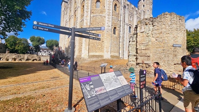
The marker is visible in the distance, between the Wardrobe Tower and the Tower of London. The remains of the Roman City Wall is also visible in the photo.
800 Jahre später wählte Wilhelm der Eroberer diesen strategisch wichtigen Standort für den Bau des Tower of London. Die alten römischen Mauern dienten als Fundamente für seine Verteidigungsanlagen.
Po inwazji na Brytanię w 43 r. n.e. Rzymianie założyli w tym miejscu osadę którą nazwali Londinium. Stała się ona ważnym ośrodkiem gospodarczym i politycznym, a w 225 r. została otoczona grubym murem obronnym. Linie na ziemi odzwierciedlają układ rzymskich murów.
800 lat później Wilhelm Zdobywca wybrał to strategiczne miejsce na budowę swojej twierdzy. Stare rzymskie mury posłużyły jako fundamenty dla nowych fortyfikacji.
После вторжения в Британию в 43 г. н.э. римляне основали городок под именем Лондиниум. Он стал важным поселением и к 225 г. н.э. уже был окружен надежной стеной. Линии на земле проведены на месте бывшей римской стены.
Восемьсот лет спустя Вильгельм Завоеватель выбрал это стратегическое место для возведения Лондонского Тауэра. Древнеримские стены стали фундаментом для новых защитных сооружений.
রোমানরা 43 খ্রীস্টাব্দে ব্রিটেন আক্রমণ করার পরে এখানে লন্ডিনিয়াম নামের একটি শহর প্রতিষ্ঠা করেছিল। শহর একটি গুরুত্বপূর্ণ স্থায়ী বসতিতে পরিণত হয়। 225 খ্রীস্টাব্দের মধ্যে এর পারিপার্শ্বে বিস্ শক্ত একটি শহরের প্রাচীর ছিল। মাটির রেখাগুলি রোমান চত্বারের চিত্র।
800 বছর পরে উইলিয়াম দ্য কনকারার এই গুরুত্বপূর্ণ স্থানিটিকে টাওয়ার অব লন্ডনের জন্য বেছে নিয়েছিলেন। পুরনো রোমান প্রাচীরগুলি তাঁর প্রতিরক্ষার ভিত্তি পরিণত হয়েছিল।
罗马人于公元43年入侵不列颠之后,在此建立了一个名为“伦蒂尼恩”的城镇。这个城成为了一个重要的定居点,到公元225年周围已修筑了厚实的城墙。地面的线条就是罗马城墙的遗迹。
800年后,征服者威廉选择这个战略要地修建伦敦教塔。旧的罗马城墙成为防御工事的地基。
ブリテン島に侵攻したローマ軍は、西暦43年、この地にロンディニウムという町を建設しました。町はその後重要な居住地となり、西暦225年までには周囲に強固な城壁が建設されました。地面のラインはローマ時代の城壁の跡を示しています。
800年後、征服王ウイリアムはこの戦略上の要地を選び、ロンドン塔を建設しました。古代ローマの壁が昔の基礎として使われました。
Topics. This historical marker is listed in this topic list: Forts and Castles.
Location. 51° 30.473′ N, 0° 4.54′ W. Marker is in Tower Hamlets, England, in Greater London. It is in St Katharine's & Wapping. It can be reached from the intersection of Tower Bridge Approach and Tower Hill, on the left when traveling north. Touch for map. Marker is in this post office area: Tower Hamlets, England EC3N 4AB, United Kingdom. Touch for directions.

Regionally, this marker is in London and in the Greater South East. Globally, it is on the Atlantic Ocean, in the North Atlantic Region, in Europe, in Atlantic Europe, on one of the British Isles, in the Western World, and in the Anglosphere. Historically, it finds itself in what was once the Roman Empire.
Other nearby markers. At least 8 other markers are within walking distance of this marker: Wardrobe Tower (here, next to this marker); White Tower (here, next to this marker); Bronze 24-pounder Cannon (a few steps from this marker); Bronze Fortress Gun (within shouting distance of this marker); Army Stores and Soldiers (within shouting distance of this marker); Bronze Gun (within shouting distance of this marker); Royal Logistic Corps Departure (within shouting distance of this marker); Iron 9-pounder Gun (within shouting distance of this marker). Touch for a list and map of all markers in Tower Hamlets.
Other markers no longer nearby. The White Tower and Roman City Wall (was here, next to this marker but has been replaced with another marker now near it); The White Tower and Royal Armouries (was here, next to this marker but has been replaced with another marker now near it); White Tower and the Two Princes (was within shouting distance of this marker but has been permanently removed).
Credits. This page was last revised on November 6, 2026. It was originally submitted on September 27, 2026, by Ian Lefkowitz of New York, New York. This page has been viewed 20 times since then. Photos: 1, 2. submitted on September 27, 2026, by Ian Lefkowitz of New York, New York. • Andrew Ruppenstein was the editor who published this page.
