Whitchurch in Shropshire, England, United Kingdom — Northwestern Europe (the British Isles)
Life in 18th & 19th century Whitchurch
Photographed by Ray Gurganus, May 18, 2026
1. Life in 18th & 19th century Whitchurch Marker
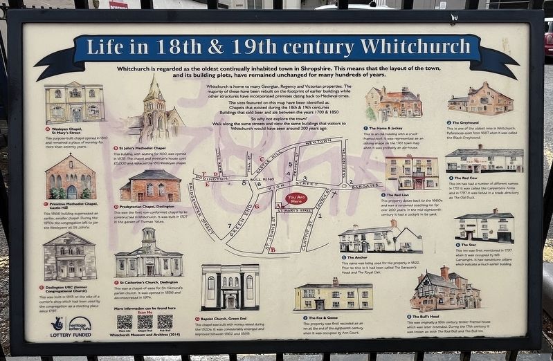
Whitchurch is home to many Georgian, Regency and Victorian properties. The majority of these have been rebuilt on the footprint of earlier buildings while other structures have incorporated premises dating back to Medieval times.
The sites featured on this map have been identified as: Chapels that existed during the 18th & 19th centuries; Buildings that sold beer and ale between the years 1700 & 1850.
So why not explore the town? Walk along the same streets and view the same buildings that visitors to Whitchurch would have seen around 200 years ago.
(A) Wesleyan Chapel, St Mary's Street
This purpose-built chapel opened in 1810 and remained a place of worship for more than seventy years.
(B) St John's Methodist Chapel
This building, with seating for 400, was opened In 1879. The chapel and minister's house cost £5,000 and replaced the 1810 Wesleyan chapel.
(C) Primitive Methodist Chapel, Castle Hill
This 1866
this page online
(D) Presbyterian Chapel, Dodington
This was the first non-conformist chapel to be constructed in Whitchurch. It was built in 1707 In the garden of Thomas Yates.
(E) Dodington URC (former Congregational Church)
This was built in 1813 on the site of a currier's shop which had been used by the congregation as a meeting place since 1797.
(F) St Catherine's Church, Dedington
This was a chapel-of-case for St Alkmund's parish church. It was opened in 1836 and deconsecrated in 1974.
(G) Baptist Church, Green End
This chapel was built with money raised during the 1820s. It was considerably enlarged and Improved between 1862 and 1889.
(1) The Horse & Jockey
This is an old building with a cruck-framed roof. It was represented as an oblong shape on the 1761 town map when it was probably an ale-house.
(2) The Greyhound
This is one of the oldest inns in Whitchurch. References exist from 1667 when it was called the Black Greyhound.
(3) The Red Lion
This property dates back to the 1660s and was a renowned coaching inn for over 200 years, in the mid-eighteenth century it had a cockpit in its yard.
(4) The Red Cow
This inn has had a number of different names In 1751 it was called the Carpenters Arms and in 1797 it was listed in a trade directory as The Old Buck.
(5) The Anchor
This name was being used for the property in 1822 Prior to this is it had been called The Saracen's Head and The Royal Oak.
(6) The Star
This inn was first mentioned in 1797 when it was occupied by Will Cartwright. It has sandstone cellars which indicate a much earlier building.
(7) The Fox & Goose
This property was first recorded as an Inn at the end of the eighteenth century when it was occupied by Ann Court.
(8) The Bull's Head
This was originally a 16th century timber framed house which was later extended. During the 17th century it was known as both The Red Bull and The Bull Inn.
Topics. This historical marker is listed in these topic lists: Industry & Commerce • Religion & Religious Structures.
Location. 52° 58.203′ N, 2° 40.992′ W. Marker is in Whitchurch, England, in Shropshire. It is on Saint Mary's Street, on the right when traveling south. The marker is located just outside the Whitchurch Heritage Centr. Touch for map. Marker is at or near this postal address: 12 St Mary's Street, Whitchurch, England SY13 1DE, United Kingdom. Touch for directions.

Regionally, this marker is in the Midlands. It is also on the British Marches. Globally, it is on the Atlantic Ocean, in the North Atlantic Region, in Europe, in Atlantic Europe, on one of the British Isles, in the Western World, and in the Anglosphere. Historically, it finds itself in what was once the Roman Empire.
Other nearby markers. At least 6 other markers are within 16 kilometers of this marker, measured as the crow flies: History on the Spot (a few steps from this marker); a different marker also named History on the Spot (about 120 meters away, measured in a direct line); Welcome to Whitchurch (approx. 0.8 kilometers away); Walks around Whitchurch (approx. 0.8 kilometers away); Whitchurch Road Cemetery (approx. 12.3 kilometers away); The Great Church of St Mary's (approx. 15.3 kilometers away).
Credits. This page was last revised on September 29, 2026. It was originally submitted on September 27, 2026, by Ray Gurganus of Washington, District of Columbia. This page has been viewed 3 times since then. Photo 1. submitted on September 27, 2026, by Ray Gurganus of Washington, District of Columbia. • Andrew Ruppenstein was the editor who published this page.
Editor’s want-list for this marker. photo of the marker within its surroundings • Can you help?
