St Katharine's & Wapping in Tower Hamlets in Greater London, England, United Kingdom — Northwestern Europe (the British Isles)
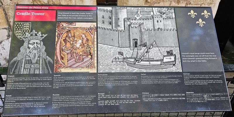
Cradle Tower
Discover the Palace story
Photographed by Ian Lefkowitz, September 11, 2026
1. Cradle Tower Marker
 [English:]
King Edward III built the Cradle Tower in the 1350s as his private entrance to the palace from the river, called a watergate.
Edward’s royal barge could moor here. The watergate was cut off from the river when Edward’s grandson King Richard II built the wharf in the 1390s.
Le roi Edouard III fit bâtir la tour du Berceau, une porte fluviale, dans les années 1350. C’était une entrée privée au palais depuis le fleuve.
La barge royale d’Edouard pouvait y être amarrée. Lors des travaux de construction du quai et d’assèchement du fleuve menés par le roi Richard II, petit-fils d’Edouard, dans les années 1390, le lit du fleuve recula.
El rey Eduardo III construyó la Torre Cradle en la década de 1350 como su entrada privada al palacio desde el río, llamada puerta del agua.
La embarcación real de Eduardo podía atracar aquí. La puerta del agua se quedó sin conexión al río cuando el rey Ricardo II, nieto de Eduardo, construyó el embarcadero en la década de 1390.
O Rei Eduardo III construiu a Torre da Nascente, na década de 1350, como entrada privada para o palácio a partir do rio (“watergate”
this page online
A barca real do Eduardo podia ser ancorada aqui. A entrada de rio foi separada do rio quando o neto de Eduardo, o Rei Ricardo II, construiu o cais na década de 1390.
Re Edoardo III costruì la torre Cradle, una porta fluviale, intorno al 1350 come ingresso privato al palazzo.
Il battello reale di Edoardo poteva essere ormeggiato qui. La porta fluviale fu isolata dal fiume quando il re Riccardo II, nipote di Edoardo, fece costruire il molo intorno al 1390.
König Eduard III. ließ den Cradle Tower um 1350 als privaten Zugang vom Fluss zum Palast errichten, auch Wassertor genannt.
Eduards königliche Barke konnte hier anlegen. Als Eduards Enkel Richard II. um 1390 die Werft erbauen ließ, wurde das Wassertor vom Fluss abgeschnitten.
Król Edward III wzniósł Cradle Tower w latach 50. XIV w. i stała się ona prywatnym wejściem do pałacu od strony rzeki – tzw. brama wodna.
Cumowała tu barka królewska Edwarda III. Brama ta została odcięta od rzeki, gdy wnuk Edwarda III, król Ryszard II wybudował w tym miejscu w latach 90. XIV w. nabrzeże.
Колыбельная
Photographed by Ian Lefkowitz, September 11, 2026
2. Cradle Tower Marker
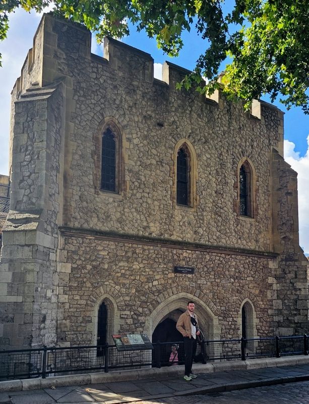
The marker is located in front of the entrance to Cradle Tower.
В том месте могла причаливать королевская баржа Эдуарда. Водные ворота оказались отрезаны от реки, после того как внук Эдуарда король Ричард II построил причал в 1390-х гг.
রাজা তৃতীয় এডওয়ার্ড 1350 এর দশকে নদী থেকে প্রাসাদে তাঁর ব্যক্তিগত প্রবেশপথ হিসেবে ক্র্যাডল টাওয়ার নির্মাণ করেছিলেন, যাকে ওয়াটারগেট বলা হয়।
এডওয়ার্ডের রাজকীয় প্রমোদতরী এখানে বোঝাই দিতে বাঁধা থাকতো। এডওয়ার্ডের নাতি রাজা তৃতীয় রিচার্ড 1390 এর দশকে ঘাট নির্মাণ করার পরে ওয়াটারগেট নদী থেকে বিচ্ছিন্ন হয়েছিল।
14世纪50年代,国王爱德华三世建造了摇篮塔,作为从泰晤士河进入宫殿的私人入口,即“水门”。
爱德华的皇家游船可在此处停泊。14世纪90年代,爱德华的孙子国王理查二建造了码头之后,水门与泰晤士河断开。
エドワード世三世は1350年代に、テムズ川からの私的な通用門(ウォーターゲート)としてクレイドル・タワーを建設しました。
エドワード王の舟はこの辺りに係留されたかもしれません。1390年にエドワードの孫にあたるリチャード二世が埠頭を建設したため、このウォーターゲートは川から切り離されました。
Erected by Historic Royal Palaces.
Topics. This historical marker is listed in this topic list: Forts and Castles.
Location. 51° 30.436′ N, 0° 4.531′ W. Marker is in Tower Hamlets, England, in Greater London. It is in St Katharine's & Wapping. It can be reached from the intersection of Tower Bridge Approach and Tower Hill, on the left when traveling north. Touch for map. Marker is in this post office area: Tower Hamlets, England E1W 1LP, United Kingdom. Touch for directions.

Regionally, this marker is in London and in the Greater South East. Globally, it is on the Atlantic Ocean, in the North Atlantic Region, in Europe, in Atlantic Europe, on one of the British Isles, in the Western World, and in the Anglosphere. Historically, it finds itself in what was once the Roman Empire.
Other nearby markers. At least 8 other markers are within walking distance of this marker: Bronze 6-pounder Gun and Carriage (a few steps from this marker); Iron 36-pounder Howitzer and Carriage (a few steps from this marker); a different marker also named The Cradle Tower (a few steps from this marker); Escape from the Tower (a few steps from this marker); Medieval Jewish Prisoners (a few steps from this marker); Bronze Gun (a few steps from this marker); Iron 13-inch Mortar and Bed (within shouting distance of this marker); Iron 13-inch Mortar (within shouting distance of this marker). Touch for a list and map of all markers in Tower Hamlets.
Credits. This page was last revised on September 28, 2026. It was originally submitted on September 27, 2026, by Ian Lefkowitz of New York, New York. This page has been viewed 6 times since then. Photos: 1, 2. submitted on September 27, 2026, by Ian Lefkowitz of New York, New York. • Andrew Ruppenstein was the editor who published this page.
