Cranston in Providence County, Rhode Island — The American Northeast (New England)
Print Works
| — | Cranston Discovery Network | — |
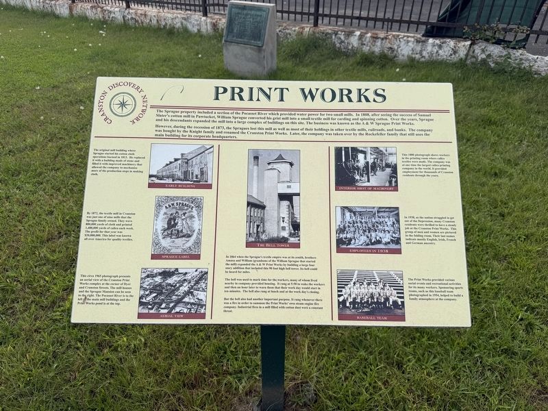
The Sprague property included a section of the Pocasset River which provided water power for two small mills. In 1808, after seeing the success of Samuel Slater's cotton mill in Pawtucket, William Sprague converted his grist mill into a small textile mill for carding and spinning cotton. Over the years, Sprague and his descendants expanded the mill into a large complex of buildings on this site. The business was known as the A & W Sprague Print Works.
However, during the recession of 1873, the Spragues lost this mill as well as most of their holdings in other textile mills, railroads, and banks. The company was bought by the Knight family and renamed the Cranston Print Works. Later, the company was taken over by the Rockefeller family that still uses the main building for its corporate headquarters.
this page online
The bell was used to mark time for the workers, many of whom lived nearby in company provided housing. It rang at 5:30 to wake the workers and then an hour later to warn them that their work day would start in ten minutes. The bell also rang at lunch and at the work
But the bell also had another important purpose. It rang whenever there was a fire in order to summon the Print Works' own steam engine fire company. Industrial fires in a mill filled with cotton dust were a constant threat.
Erected by Cranston Discovery Network.
Topics. This historical marker is listed in these topic lists: Communications • Industry & Commerce • Sports. A significant historical year for this entry is 1808.
Location. 41° 47.429′ N, 71° 27.441′ W. Marker is in Cranston, Rhode Island, in Providence County. It is at the intersection of Cranston Street and Dyer Avenue, on the right when traveling west on Cranston Street. Touch for map. Marker is at or near this postal address: 1370 Cranston St, Cranston RI 02920, United States of America. Touch for directions.

Regionally, this marker is in Greater Providence. It is also in the American Northeast, in New England, and on the Eastern Seaboard. Globally, it is in the North Atlantic Region, North America, the Western Hemisphere, the Western World, and the Anglosphere. Historically, it finds itself in what was once one of the original Thirteen Colonies.
Other nearby markers. At least 8 other markers are within 2 miles of this marker, measured as the crow flies: Clarence Surprise Square (here, next to this marker); Spragueville (within shouting distance of this marker); Vietnam War (approx. 1.3 miles away); Viet Nam Memorial Quadrangle (approx. 1.3 miles away); Armed Forces Memorial (approx. 1.4 miles away); World War II, Korean Conflict and Vietnam War Memorial (approx. 1.4 miles away); Veterans Memorial (approx. 1.4 miles away); RI Freedom Monument (approx. 1.4 miles away). Touch for a list and map of all markers in Cranston.
Credits. This page was last revised on September 30, 2026. It was originally submitted on September 29, 2026, by Devry Becker Jones of Washington, District of Columbia. This page has been viewed 4 times since then. Photos: 1, 2. submitted on September 29, 2026, by Devry Becker Jones of Washington, District of Columbia.
