Clayville in Scituate in Providence County, Rhode Island — The American Northeast (New England)
Clayville: Comb Factory Village
Scituate Heritage Trail
| — | Historic Scituate, Rhode Island | — |
Photographed by Devry Becker Jones (CC0), September 19, 2026
1. Clayville: Comb Factory Village Marker
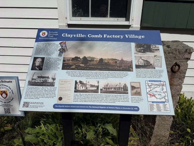
Clayville’s original name was Comb Factory Village. The village's industrial era began around 1826, when General Josiah Whitaker, a Providence merchant and director of the Old Stone Bank, moved to the area. Whitaker opened a store and operated a factory that made imitation tortoiseshell combs. When the combs, made from oxen horns, fell out of fashion, the factory transitioned to producing overshoes. Eventually, the mills turned to the lucrative production of textiles.
This village was renamed "Clayville" in honor of Henry Clay (left), at a ceremony on July 4, 1829, by Josiah Whitaker. Clay was a U.S. Senator from Kentucky and an advocate for American business. He was known as "The Great Compromiser" for his efforts to prevent the looming war over slavery.
The Scituate Asylum, or "Poor Farm," was located on George Washington Highway. The poor farms of the era provided a town’s indigent population with a place to live and work. The Social Security Act of 1935 led to the slow decline of poor farms. Scituate's was demolished in the 1950s, and in the 1970s the Scituate Animal Shelter was constructed on the site to, fittingly,
this page online
This oil painting of Clayville was produced by an unidentified artist circa 1850. Though the artist took some liberties, the work is a fair representation of the village at that time. An art collector discovered the painting in New Jersey in the 1960s. Postcards were sent to post offices all over New England to identify the village, and an observant postmaster recognized it as Clayville. The historic district is divided into two towns. The old schoolhouse is in Scituate, and the old church and cemetery can be found in Foster.
In April 1906, the Joslin Manufacturing Company incorporated the Clayville Manufacturing Company (left) to produce shoe and corset laces in Clayville’s mills (above, left). Ten years later, the City of Providence launched the Scituate Reservoir project. Mill owner William H. Joslin built an estate at the top of Field Hill (right), with a commanding view to the north and east, where prize-winning cattle were kept. The City of Providence later acquired the property, and by 2000 all the estate structures had
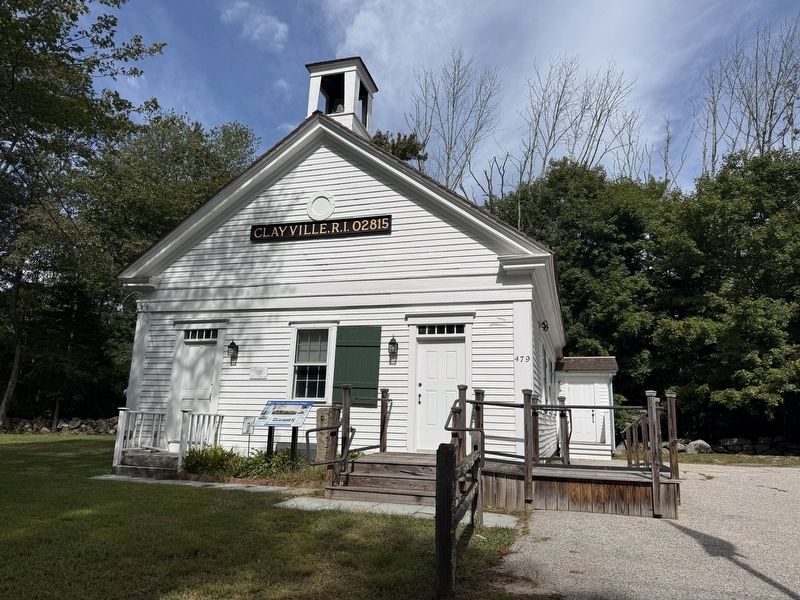
Before the construction of the Scituate Reservoir, Clayville was a thriving village. Trolleys regularly transported residents to and from Providence (top). The one-room Clayville Schoolhouse was built in 1845 on a lot donated by Josiah Whitaker. At right is a portrait from 1900 of Lena M. Howard, a teacher at the school.
Children fishing in the same mill pond that is depicted in the painting.
Erected 2021 by Town of Scituate, Rhode Island. (Marker Number 17.)
Topics. This historical marker is listed in these topic lists: Industry & Commerce • Settlements & Settlers. A significant historical month for this entry is April 1906.
Location. 41° 46.456′ N, 71° 40.359′ W. Marker is in Scituate, Rhode Island, in Providence County. It is in Clayville. It is on Field Hill Road west of Knight Hill Road, on the right when traveling west. Touch for map. Marker is at or near this postal address: 479 Field Hill Rd, Clayville RI 02815, United States of America. Touch for directions.

Regionally, this marker is

Photographed by Devry Becker Jones (CC0), September 19, 2026
3. Sign on the Clayville School
District No. 17
Circa. 1845
Other nearby markers. At least 8 other markers are within 3 miles of this marker, measured as the crow flies: New Rockland Cemetery (approx. half a mile away); Gaetano Del Guidice (approx. 1½ miles away); Grover C. Walker Memorial (approx. 1.6 miles away); Foster Town House (approx. 2.6 miles away); Veterans Memorial (approx. 2.6 miles away); WW II Veterans Memorial (approx. 2.6 miles away); Benjamin Eddy Building (approx. 2.6 miles away); Town Jail (approx. 2.6 miles away). Touch for a list and map of all markers in Scituate.
Credits. This page was last revised on October 3, 2026. It was originally submitted on October 3, 2026, by Devry Becker Jones of Washington, District of Columbia. This page has been viewed 2 times since then. Photos: 1, 2, 3. submitted on October 3, 2026, by Devry Becker Jones of Washington, District of Columbia.
