North Scituate in Providence County, Rhode Island — The American Northeast (New England)
The Lost Villages of Scituate
Scituate Heritage Trail
| — | Historic Scituate, Rhode Island | — |
Photographed by Devry Becker Jones (CC0), September 19, 2026
1. The Lost Villages of Scituate Marker
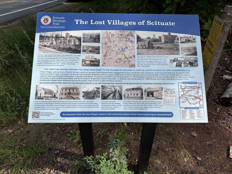
Ashland village (above) was home to the Ashland Mill. The village once featured sawmill and gristmills before turning to textiles. The area is now submerged below the Ashland Causeway, which was constructed in the early 1920s (right, top). The remains of Ashland disappeared as the reservoir waters rose (right, center). However, not all homes were lost — Sheldon House (right, bottom) was reconstructed in Providence.
The small mill village of Kent also featured several farms (above, and right, top). The area is now the site of the Gainer Dam (formerly known as the Kent Dam), which began construction in 1920 (right, center, and bottom). The gatehouse was still under construction when citizens toured the dam in 1926 (right).
this page online
South Scituate School #13 (above, left) was one of seven schools torn down during the construction of the reservoir. Students whose families stayed in Scituate transferred to other schools in town. The Shafford House of South Scituate (center) served as a post office, and later as headquarters for the chief engineer of the reservoir project. Activities for residents in South Scituate included fox hunting (right).
The
Photographed by Devry Becker Jones (CC0), September 19, 2026
2. The Lost Villages of Scituate Marker
The village of Saundersville, which once featured a bank, school, homes, two cotton mills, and a braid factory, fell into decline by the end of the 19th century. A 1925 auction in the village included horses, wagons, and all that went with running a farm, including pigs.
Erected 2021 by Town of Scituate, Rhode Island. (Marker Number 13.)
Topics. This historical marker is listed in these topic lists: Charity & Public Work • Education • Natural Resources • Settlements & Settlers. A significant historical date for this entry is April 9, 1915.
Location. 41° 47.377′ N, 71° 36.358′ W. Marker is in Scituate, Rhode Island, in Providence County. It is in North Scituate. It is on Plainfield Pike (Rhode Island Route 14) east of Battery Meeting House Fire Lane, on the right when traveling east. Touch for map. Marker is at or near this postal address: 324-298 RI-14, North Scituate RI 02857, United States of America. Touch for directions.

Regionally, this marker is in the Quiet Corner and in Greater Providence. It is also in the American Northeast, in New England, and on the Eastern Seaboard. Globally, it is in the North Atlantic Region, North America, the Western Hemisphere, the Western World, and the Anglosphere. Historically, it finds itself in what was once one of the original Thirteen Colonies.
Other nearby markers. At least 8 other markers are within 4 miles of this marker, measured as the crow flies: Grover C. Walker Memorial (approx. 2.8 miles away); Gaetano Del Guidice (approx. 2.8 miles away); Esek Hopkins • 1718-1802 (approx. 2.9 miles away); Scituate, Rhode Island (approx. 3.1 miles away); Stephen Hopkins • 1707-1785 (approx. 3.1 miles away); Owen Soldiers' Monument (approx. 3.2 miles away); Old Congregational Church (approx. 3.3 miles away); The Village of North Scituate / Scituate, Rhode Island (approx. 3.3 miles away). Touch for a list and map of all markers in Scituate.
Additional keywords. rural displacement
Credits. This page was last revised on October 3, 2026. It was originally submitted on October 3, 2026, by Devry Becker Jones of Washington, District of Columbia. This page has been viewed 3 times since then. Photos: 1, 2. submitted on October 3, 2026, by Devry Becker Jones of Washington, District of Columbia.
