St Katharine's & Wapping in Tower Hamlets in Greater London, England, United Kingdom — Northwestern Europe (the British Isles)
St Thomas’s Tower
Discover the Palace story
Photographed by Ian Lefkowitz, September 11, 2026
1. St Thomas’s Tower Marker

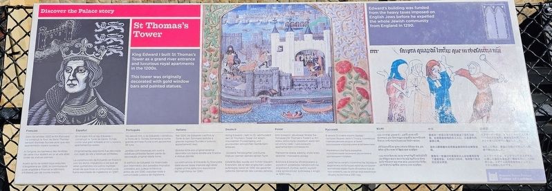
King Edward I built St Thomas’s Tower as a grand river entrance and luxurious royal apartments in the 1200s.
This tower was originally decorated with gold window bars and painted statues.
Edward’s building was funded from the heavy taxes imposed on English Jews before he expelled the whole Jewish community from England in 1290.
Dans les années 1200 le Roi Edouard I a construit la Tour de Saint Thomas servant d’entrée fluviale ainsi que des appartements royaux luxueux.
À l’origine, les barreaux des fenêtres de cette tour étaient en or et elle était ornée de statues peintes.
Avant qu’ils ne soient tous expulsés d’Angleterre en 1290, la communauté juive anglaise a financé le bâtiment d’Edward, par de lourds impôts.
En el siglo XIII, el rey Eduardo I construyó la Torre de Santo Tomás como una gran entrada al río y lujosos apartamentos reales.
Originalmente, esta torre fue decorada con rejas de oro y estatuas pintadas.
La construcción de Eduardo se financió con los duros impuestos a los que se veían sometidos los judíos ingleses antes de que toda la comunidad judía fuera expulsada de
this page online
No século XIII, o rei Eduardo I construiu a Torre de S. Tomás, tornando-a numa grande entrada fluvial e em aposentos de luxo.
Janelas com travessas em ouro e estátuas pintadas faziam parte da decoração original desta torre.
O edifício de Eduardo foi financiado por intermédio dos pesados impostos cobrados aos judeus britânicos antes de, em 1290, expulsar toda a comunidade judaica de Inglaterra.
Nel 1200, Re Edoardo I edificò la Torre di San Tommaso adibita a grande ingresso fluviale e lussuosi appartamenti reali.
Questa torre era originariamente decorata con barre dorate alle finestre e statue dipinte.
La costruzione di Edoardo fu finanziata dalle esose tasse imposte agli ebrei inglesi prima della loro espulsione dall’Inghilterra nel 1290.
König Edward I. ließ im 13. Jahrhundert den St Thomas’s Tower mit einem imposanten Flusseingang und prunkvollen königlichen Gemächern erbauen.
Goldene Fensterstäbe und bunte Statuen zierten damals seinen Turm.
Edwards Bau wurde von hohen Steuern finanziert, die er den englischen Juden auferlegte, bevor er 1290 die gesamte jüdische Gemeinde des Landes
Photographed by Ian Lefkowitz, September 11, 2026
2. St Thomas’s Tower Marker
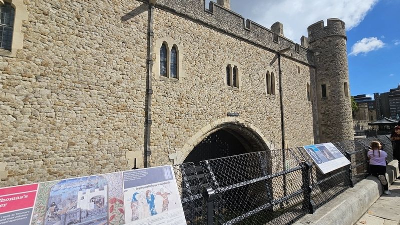
This marker is located on the wharf, facing St. Thomas's Tower.
Król Edward I zbudował Wieżę Św. Tomasza (St Thomas’s Tower) w XIII wieku, która była okazałym wejściem od strony rzeki i luksusowymi apartamentami królewskimi.
Pierwotnie wieżę zdobiły złote kraty okienne i malowane posągi.
Budowlę Edwarda sfinansowano z wysokich podatków nałożonych na angielskich Żydów, zanim wysiedlił całą społeczność żydowską z Anglii w 1290 roku.
В начале 13-го века король Эдуард I построил башню Святого Фомы с парадным речным входом, а также роскошными королевскими апартаментами.
Изначально она была украшена позолоченными оконными решётками и расписными статуями.
Средства на начало строительства Эдуарда выделялись из больших налогов, которые английские евреи были обложены ещё до того момента, как он изгнал всю еврейскую общину из Англии в 1290 году.
1200 তে রাজা এডওয়ার্ড। একটি গ্র্যান্ড নদী প্রবেশদ্বার এবং বিলাসবহুল রাজকীয় অ্যাপার্টমেন্ট হিসাবে সেন্ট থমাস টাওয়ারের নির্মাণ করেন।
এই টাওয়ারটিকে মূলত সোনার উইলো বার এবং আঁকা মূর্তির সঙ্গে সজ্জিত করা হয়েছিল।
1290 সালে ইংল্যান্ড থেকে সম্পূর্ণ ইহুদি কমিউনিটি কে বহিষ্কৃত করার আগে ইহুদীদের উপর ভারি পরিমাণে কর লাগু করে এডওয়ার্ডের বিল্ডিং এর নির্মাণের আর্থিক যোগান দেয়া হয়েছিল।
爱德华一世国王在13世纪建造了圣托马斯塔。此塔既是宏伟的水上入口,又是豪华的皇家公寓。
圣托马斯塔最初采用黄金贴和彩绘雕像装饰。
爱德华一世通过对英国犹太人征收重税获得了建塔资金;大约在1290年,他将整个犹太社区逐出英国。
エドワード一世は、セント・トーマス・タワーの壮大な水門と豪華な王室用アパートメントを1200年代に建設しました。
当初この塔は、黄金の忍冬子や彩色された彫像で飾られました。
エドワード王は、イングランドのユダヤ人に課した重税を資金源に建設を行い、1290年には、ユダヤ人共同体全体をイングランドから追放したのです。
Erected by Historic Royal Palaces.
Topics. This historical marker is listed in these topic lists: Forts and Castles • Religion & Religious Structures. A significant historical year for this entry is 1290.
Location. 51° 30.443′ N, 0° 4.624′ W. Marker is in Tower Hamlets, England, in Greater London. It is in St Katharine's & Wapping. It can be reached from the intersection of Tower Bridge Approach and Tower Hill, on the left when traveling north. Touch for map. Marker is in this post office area: Tower Hamlets, England EC3N 4EE, United Kingdom. Touch for directions.

Regionally, this marker is in London and in the Greater South East. Globally, it is on the Atlantic Ocean, in the North Atlantic Region, in Europe, in Atlantic Europe, on one of the British Isles, in the Western World, and in the Anglosphere. Historically, it finds itself in what was once the Roman Empire.
Other nearby markers. At least 8 other markers are within walking distance of this marker: Traitors' Gate (here, next to this marker); a different marker also named St Thomas's Tower (a few steps from this marker); a different marker also named Traitors' Gate (within shouting distance of this marker); Layers of Defence (within shouting distance of this marker); Guarding the Tower (within shouting distance of this marker); Pushing Back the River (within shouting distance of this marker); Gateway to the Sea (within shouting distance of this marker); Royal Beasts (within shouting distance of this marker). Touch for a list and map of all markers in Tower Hamlets.
Another marker is no longer nearby. The Tower Wharf (was within shouting distance of this marker but has been permanently removed).
Credits. This page was last revised on October 4, 2026. It was originally submitted on October 3, 2026, by Ian Lefkowitz of New York, New York. This page has been viewed 10 times since then. Photos: 1, 2. submitted on October 3, 2026, by Ian Lefkowitz of New York, New York. • Andrew Ruppenstein was the editor who published this page.
