Pennsville in Pennsville Township in Salem County, New Jersey — The American Northeast (Mid-Atlantic)
Officer's Row
Fort Mott State Park
| — | Division of Parks and Forestry | — |
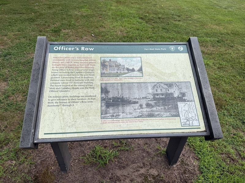
Since Fort Mott was a self contained community with its own hospital, school, library, and YMCA, many married officers brought their families to live with them on the post in Army provided housing. Along Officer's Row were several single homes including the Captain's Quarters, which was located next to the post headquarters. Lieutenants lived in duplexes. Enlisted men lived in barracks with one company (about 107 men) per building. The house located at the corner of Fort Mott and Cemetery Roads was the Field Officers' Quarters.
On military posts, buildings are numbered to give reference to their location. At Fort Mott, the houses of Officers' Row were numbered 1 through 8.
[Captions:]
Officer's Row, circa 1905. Many of the buildings at Fort Mott were adorned with cannonballs.
In 1932, several buildings were transported on barges across the river to Fort DuPont in Delaware as part of a military exercise and a few remain there today.
Erected by New Jersey Division of Parks and Forestry.
Topics. This historical marker is listed in these topic lists: Forts and Castles • Military. A significant historical year for this entry is 1905.
Location. 39° 36.286′ N,
this page online

Regionally, this marker is in Greater Wilmington, in South Jersey, and in Greater Philadelphia. It is also in the American Northeast, in the Mid-Atlantic, and on the Eastern Seaboard. Globally, it is in the North Atlantic Region, North America, the Western Hemisphere, the Western World, and the Anglosphere. Historically, it finds itself in what was once New Netherland and also one of the original Thirteen Colonies.
Other nearby markers. At least 8 other markers are within walking distance of this marker: Post Headquarters (a few steps from this marker); Parade Ground (within shouting distance of this marker); Observation Towers (within shouting distance of this marker); The Moat and the Parados (within shouting distance of this marker); Battery Gregg (about 500 feet away, measured
Credits. This page was last revised on October 4, 2026. It was originally submitted on October 4, 2026, by Devry Becker Jones of Washington, District of Columbia. This page has been viewed 2 times since then. Photos: 1, 2. submitted on October 4, 2026, by Devry Becker Jones of Washington, District of Columbia.
