St. Clair Shores in Macomb County, Michigan — The American Midwest (Great Lakes)
Shore Line Interurban Railway
Photographed by J.T. Lambrou, September 27, 2026
1. Shore Line Interurban Railway Marker
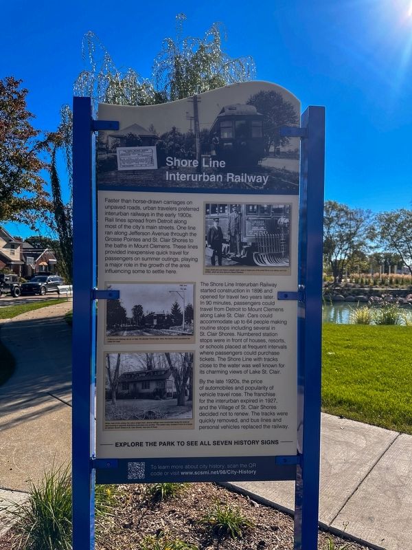
Faster than horse-drawn carriages on unpaved roads, urban travelers preferred interurban railways in the early 1900s. Rail lines spread from Detroit along most of the city's main streets. One line: ran along Jefferson Avenue through the Grosse Pointes and St. Clair Shores to the baths in Mount Clemens. These lines provided inexpensive quick travel for passengers on summer outings, playing a major role in the growth of the area influencing some to settle here.
The Shore Line Interurban Railway started construction in 1896 and opened for travel two years later. In 90 minutes, passengers could travel from Detroit to Mount Clemens along Lake St. Clair. Cars could accommodate up to 64 people making routine stops including several in St. Clair Shores. Numbered station stops were in front of houses, resorts, or schools placed at frequent intervals where passengers could purchase tickets. The Shore Line with tracks close to the water was well known for its charming views of Lake St. Clair.
By the late 1920s, the price of automobiles and popularity of vehicle travel rose. The franchise for the interurban
this page online
Erected 2026.
Topics. This historical marker is listed in this topic list: Railroads & Streetcars. A significant historical year for this entry is 1896.
Location. 42° 28.545′ N, 82° 53.34′ W. Marker is in St. Clair Shores, Michigan, in Macomb County. It is at the intersection of Jefferson Avenue and Revere Street, on the right when traveling north on Jefferson Avenue. Touch for map. Marker is at or near this postal address: 24800 Jefferson Avenue, Saint Clair Shores MI 48080, United States of America. Touch for directions.

Regionally, this marker is in Southeast Michigan and in Greater Detroit. It is also in the American Midwest. Globally, it is in North America, on the Great Lakes, in the Western Hemisphere, in the Western World, and in the Anglosphere. Historically, it finds itself in what was once the Northwest Territory.
Other nearby markers. At least 8 other markers are within walking distance of this marker: A different marker also named Shore Line Interurban Railway
Photographed by J.T. Lambrou, September 27, 2026
2. Shore Line Interurban Railway Marker
Related marker. Click here for another marker that is related to this marker.
Also see . . . Detroit, Lake Shore and Mt. Clemens Railway.
The Detroit, Lake Shore and Mt. Clemens Railway, also known as the Shore Line Interurban, is a defunct interurban which operated in the Detroit area in the late 1890s. The company incorporated on July 3, 1896 to construct a 23-mile (37 km) line from Detroit through 'the Points' and out to Mt. Clemens. This line opened on September 28, 1898. On March 24, 1900, the company was bought by the Detroit and Lake St. Clair Railway. After 31 years of service to Detroit's east(Submitted on October 5, 2026, by J.T. Lambrou of New Boston, Michigan.)side, service ended in 1927 on the 28 mile line.Photographed by J.T. Lambrou, September 27, 20263. Shore Line Interurban Railway MarkerLocation of the marker

Credits. This page was last revised on October 13, 2026. It was originally submitted on October 5, 2026, by J.T. Lambrou of New Boston, Michigan. This page has been viewed 4 times since then. Photos: 1, 2, 3. submitted on October 5, 2026, by J.T. Lambrou of New Boston, Michigan. • Andrew Ruppenstein was the editor who published this page.
