Boron in San Bernardino County, California — The American West (Pacific Coastal)
The Randsburg Railway
Photographed by Frank Gunshow Sanchez, October 11, 2026
1. The Randsburg Railway Marker
The Randsburg Railway
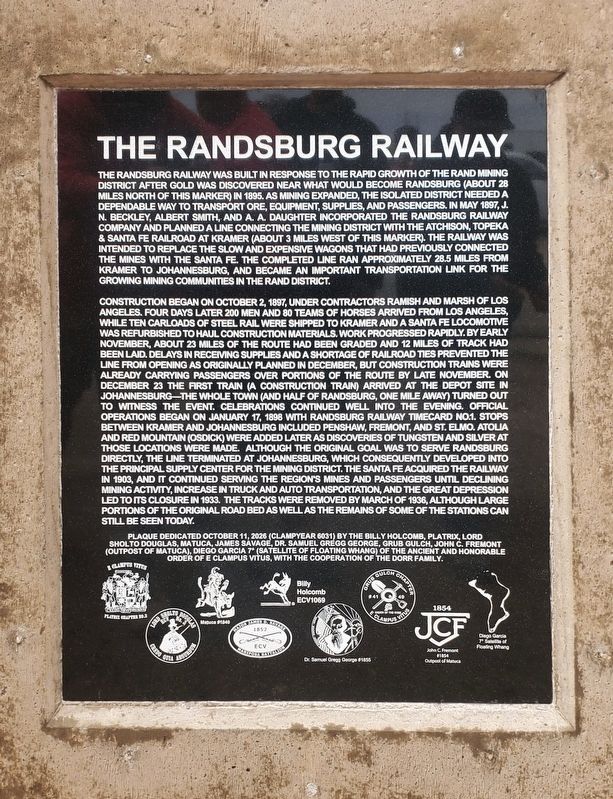
The Randsburg Railway was built in response to the rapid growth of the Rand Mining District after gold was discovered near what would become Randsburg (about 28 miles north of this marker) in 1895. As mining expanded, the isolated district needed a dependable way to transport ore, equipment, supplies, and passengers. In May 1897, J. N. Beckley, Albert Smith, and A. A. Daughter incorporated the Randsburg Railway Company and planned a line connecting the mining district with the Atchison, Topeka, Santa Fe Railroad at Kramer (about 3 miles west of this marker.) The railway was intended to replace the slow and expensive wagons that had previously connected the mines with the Santa Fe. The completed line ran approximately 28.5 miles from Kramer to Johannesburg, and became an important transportation link for the growing mining communities in the Rand District.
Construction began on October 2, 1897, under contractors Ramish and Marsh of Los Angeles. Four days later 200 men and 80 teams of horses arrived from Los Angeles while ten carloads of steel rail were shipped to Kramer and a Santa Fe Locomotive
this page online

Photographed by Frank Gunshow Sanchez, October 11, 2026
2. The Randsburg Railway Marker
Erected 2026 by Billy Holcomb Chapter 1069, Platrix Chapter 2, Lord Sholto Douglas Chapter 3, Matuca Chapter 1849, James Savage Chapter 1852, Dr Samuel Gregg George Chapter 1855, Grub-Gulch Chapter 41 - 49, Hohn C Fremont Outpost 1854, Diego Garcia Satellite 7 of E Clampus Vitus.
Topics and series. This historical marker is listed in these topic lists: Railroads & Streetcars • Settlements & Settlers. In addition, it is included in the E Clampus Vitus series list.
Location. 34° 59.666′ N, 117° 32.557′ W. Marker is in Boron, California, in San Bernardino County. It is on U.S. 395, on the right when traveling south. Marker can be seen to the right at Kramer Junction when traveling south on US - 395. Touch for map. Marker is at or near this postal address: 101 US-395, Boron CA 93516, United States of America. Touch for directions.

Regionally, this marker is in Greater Los Angeles, in the Mojave Desert, in the Peninsular Ranges, and specifically in the Transverse Ranges. It is also in the American Southwest. Globally, it is in North America, on the Ring of Fire, on the Pacific Rim, in the Western Hemisphere, in the Western World, and in the Anglosphere. Historically, it finds itself in what was once New Spain and also Mexico’s Alta California.
Other nearby markers. At least 8 other markers are within 10 miles of this marker, measured as the crow flies: Miner's Cabin (approx. 6.1 miles away); Florence Lowe “Pancho” Barnes (approx. 6.1 miles away); Twenty-Mule Teams (approx. 6.1 miles away); Twenty-Mule Team Borax Wagon (approx. 8½ miles away); a different marker also named Miner's Cabin (approx. 8½ miles away); Twenty Mule Team (approx. 8.6 miles away); Capt. Mel Apt, USAF (approx. 8.6 miles away); Rocket Site (approx. 9.8 miles away). Touch for a list and map of all markers in Boron.
Credits. This page was last revised on October 14, 2026. It was originally submitted on October 11, 2026, by Frank Gunshow Sanchez of Hollister, California. This page has been viewed 10 times since then. Photos: 1, 2. submitted on October 11, 2026, by Frank Gunshow Sanchez of Hollister, California. • Andrew Ruppenstein was the editor who published this page.
