Ludlow in Shropshire, England, United Kingdom — Northwestern Europe (the British Isles)
Castle Square & the Market
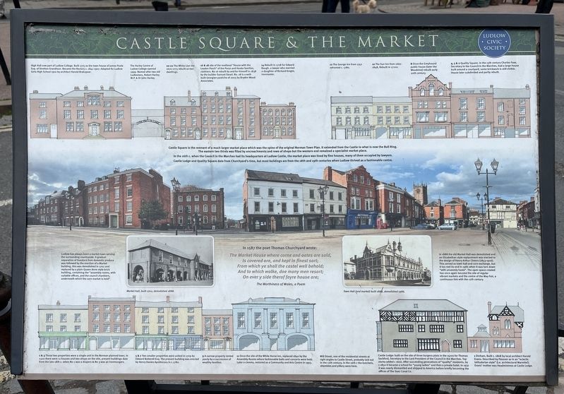
Photographed by Ray Gurganus, May 17, 2026
1. Castle Square & the Market Marker
In the 16th c. when the Council in the Marches had its headquarters at Ludlow Castle, the market place was lined by fine houses, many of them occupied by lawyers. Castle Lodge and Quality Square date from Churchyard's time, but most buildings are from the 18th and 19th centuries when Ludlow thrived as a fashionable centre.
In 1587 the poet Thomas Churchyard wrote:
The Market House where corne and oates are sold,
Is covered ore, and kept in finest sort; From which ye shall the castel well behold;
And to which walke, doe many men resort;
On ever y side therof fayre house are;
The Worthiness of Wales, a Poem
• High Hall now part of Ludlow College. Built 1775 as the town house of James Poole Esq. of Stretton Grandison. Became the Rectory с.1841-1907. Adapted for Ludlow Girls High School 1910 by architect Harold Brakspear.
•
this page online
• 20-22 The White Lion Inn 1670-1773 rebuilt as two dwellings.
• 16 & 18 site of the medieval "House with the Leaden Porch" of the Parys and Hooke families, clothiers. No 16 rebuilt by and for himself in 1838 by the builder Samuel Stead. No. 18 is a well-built Georgian pastiche of 2003 by Bryden Wood Associates.
• 14 Rebuilt in 1728 for Edward Baugh, a lawyer who married a daughter of Richard Knight, Ironmaster.
• 12 The George Inn from 1742 refronted c. 1780.
• 10 The Sun Inn from 1660-1848, Rebuilt in 17205.
• 8 Once the Greyhound public house (later the Woodvine) rebuilt early 20th century.
• 4, 5 & 2 Quality Square. In the 15th century Charles Foxe, Secretary to the Council in the Marches, had a large house built around a courtyard, some brickwork is still visible. House later subdivided and partly rebuilt.
• Ludlow has always been a market town serving the surrounding countryside. A gradual separation of livestock from domestic produce was followed by the erection of a Market building, this was demolished in 1702 and replaced by a plain Queen Anne style brick building, containing the "assembly rooms, with suitable offices, and the council chambers, underneath which the corn market is held".
• 1 & 3 These two properties were a single unit in the Norman planned town. In 1320 there were 11 houses and two shops on the site, present buildings date from the late 18th c. when No 1 was a drapers & No 3 was an ironmongers.
• 5 & 7 Two smaller properties were united in 1709 by Edward Botterell Esq. The present building was erected by Henry Davies Apothecary in c.1780.
• 9 A narrow property rented yearly by a succession of wealthy families.
• 11 Once the site of the White Horse Inn, replaced 1840 by the Assembly Rooms where fashionable balls and concerts were held. Later a cinema, restored as a Community and Arts Centre in 1993.
• Mill Street, one of the residential streets at right angles to Castle Street, probably laid out in the 12th century. In the 16th c the butchers, shambles and pillory were here.
• In 1888 the old Market Hall was demolished and an Elizabethan style replacement was erected to the design of Henry Arthur Cheers (1853-1916). This served as town hall and corn exchange, but it too met its end in 1986 when it was torn down "with unseemly haste". The open space created has once again become the site of regular vibrant markets and the centre of the May Fair, a continuous link with the 12th century.
• Castle Lodge: built on the site of three burgess plots in the 1570s for Thomas Sackford, Secretary to the Lord President of the Council in the Marches. Top storey added c 1600. After succeeding generations of "quality" residents, by c 1850 it became a school for "young ladies" and then a private hotel. In 1931 it was nearly dismantled and shipped to America before briefly becoming the offices of The Suez Canal Co.
• 1 Dinham, Built c. 1868 by local architect Harold Evans. Described by Pevsner as in an "eclectic latitudarian style" (i.e. architectural Marmite!). Evans' mother was Headmistress at Castle Lodge.
Erected by Ludlow Civic Society.
Topics. This historical marker is listed in these topic lists: Industry & Commerce • Notable Buildings.
Location. 52° 22.033′ N, 2° 43.265′ W. Marker is in Ludlow, England, in Shropshire. It is on Castle Street. Touch for map. Marker is at or near this postal address: 22 Castle St, Ludlow, England SY8 1AS, United Kingdom. Touch for directions.

Regionally, this marker is in the Midlands. It is also on the British Marches. Globally, it is on the Atlantic Ocean, in the North Atlantic Region, in Europe, in Atlantic Europe, on one of the British Isles, in the Western World, and in the Anglosphere. Historically, it finds itself in what was once the Roman Empire.
Other nearby markers. At least 8 other markers are within walking distance of this marker: Mill Street (a few steps from this marker); 11-13 Castle Street (a few steps from this marker); Edward V (within shouting distance of this marker); Castle Square (within shouting distance of this marker); Ludlow Town (within shouting distance of this marker); 2 Dinham (within shouting distance of this marker); 7 Dinham (within shouting distance of this marker); 8 High Street (about 90 meters away, measured in a direct line). Touch for a list and map of all markers in Ludlow.
Credits. This page was last revised on October 13, 2026. It was originally submitted on October 13, 2026, by Ray Gurganus of Washington, District of Columbia. This page has been viewed 12 times since then. Photo 1. submitted on October 13, 2026, by Ray Gurganus of Washington, District of Columbia. • Andrew Ruppenstein was the editor who published this page.
Editor’s want-list for this marker. Photo of the marker within its surroundings • Can you help?
