Ramsgate in Kent, England, United Kingdom — Northwestern Europe (the British Isles)
Shrine of St Augustine
| — | Ramsgate Military & Heritage Trail | — |
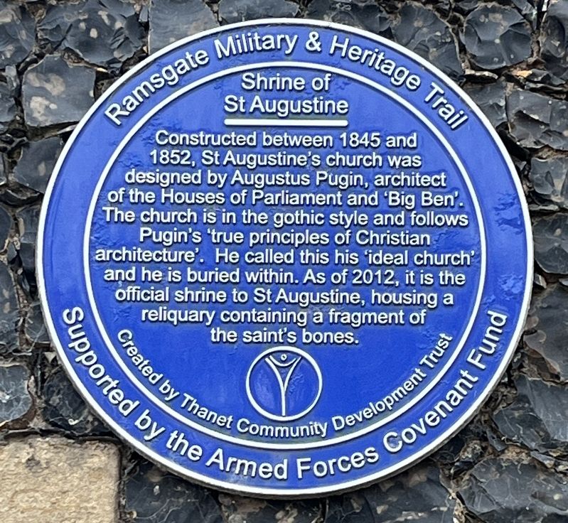
Photographed by Ray Gurganus, April 2, 2026
1. Shrine of St Augustine Marker
Erected by Thanet Community Development Trust.
Topics. This historical marker is listed in these topic lists: Architecture • Religion & Religious Structures. A significant historical year for this entry is 1845.
Location. 51° 19.717′ N, 1° 24.615′ E. Marker is in Ramsgate, England, in Kent. It is on Saint Augustine's Road, on the right when traveling east. Touch for map. Marker is at or near this postal address: 9 St Augustine's Road, Ramsgate, England CT11 9NZ, United Kingdom. Touch for directions.

Regionally, this marker is in the Greater South East. Globally, it is on the Atlantic Ocean, in the North Atlantic Region, in Europe, in Atlantic Europe, on one of the British Isles, in the Western
this page online
Other nearby markers. At least 8 other markers are within 5 kilometers of this marker, measured as the crow flies: Ramsgate People & Places - West Cliff (approx. 0.6 kilometers away); Mary Woolstonecraft Shelley (approx. 0.9 kilometers away); Canadian Voluntary Aid Detachment Hospital (approx. one kilometer away); In Step With Pugin (approx. one kilometer away); The Royal Victoria Pavilion (approx. one kilometer away); St Laurence Churchyard (approx. 1.1 kilometers away); The Beginning of English History (approx. 2.6 kilometers away); Viking Bay (approx. 4 kilometers away). Touch for a list and map of all markers in Ramsgate.

Photographed by Ray Gurganus, April 2, 2026
2. Shrine of St Augustine and Marker
Credits. This page was last revised on November 3, 2026. It was originally submitted on November 1, 2026, by Ray Gurganus of Washington, District of Columbia. This page has been viewed 7 times since then. Photos: 1, 2. submitted on November 1, 2026, by Ray Gurganus of Washington, District of Columbia. • Andrew Ruppenstein was the editor who published this page.
