Dover in Kent, England, United Kingdom — Northwestern Europe (the British Isles)
Market Square
Historic Dover
Photographed by Ray Gurganus, April 2, 2026
1. Market Square Marker
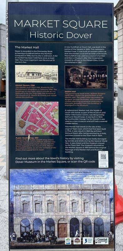
The Market Hall
Dover is recorded in the Domesday Book as having a Guildhall before the Norman Conquest in 1066, but its site is unknown. A fair or market has been held here since at least 1160. The most important was the annual St Martin's Fair.
A new Guildhall, or Court Hall, was built in the centre of the Square in 1605. This replaced a Market Cross. It was built on wooden pillars so that the market could still be held underneath. The Guildhall was used as a council chamber and then a Museum after the Corporation moved its offices to the Maison Dieu. It was demolished in 1861.
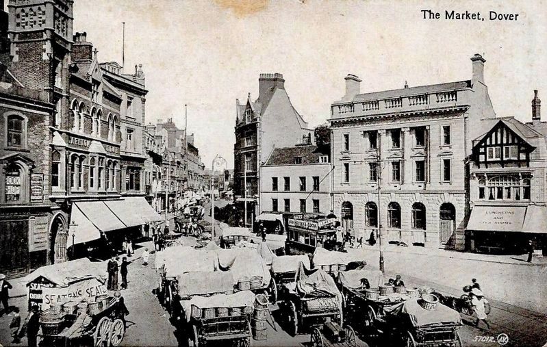
A replacement Market Hall, the facade of which still stands as part of the Museum and Visitor Information Centre, was designed by Edmund Woodthorpe. It was built in 1846 by local builder George Fry for £3,448. It was used as a new museum and still had a covered market below.
This Market Hall stood on the site of the original Town Gaol, which had first been built in 1746. It was rebuilt in 1820 by architect Richard Elsam after being wrecked by a mob and then moved to the Town Hall in 1834.
The Market Hall building was badly damaged by bombs and shells during the Second World War. It was closed and the museum moved to the Town Hall The museum returned to the Market Square in 1991 behind the original frontage of the Market Hall and Museum building.
Photo Captions
Market Square, 1788
The Market and Court Hall drawn for the Gentleman's Magazine in February 1788. The buildings on the right which include an inn believed to be the Ship, hide the remains of the church of St Martin-le-Grand, just visible above the rooftops.
Public Health Map 1857
Rowland Rees' Public Health map shows the Old Market and Guildhall, and the new Market Hall and Museum. Access into the Burial Ground of the church of St. Martin le-Grand is visible,
this page online
Market Hall
This painting by local artist William Burgess 1805-1861 shows the ground floor of the Market Hall. The pillars were decorated, as Burgess' picture illustrates, with wooden corbels depicting grotesque creatures. An example, probably from this building, is displayed in the Museum.
Market Hall and Museum
Architect's drawing for the new Market Hall and Museum, designed by Edmund Woodthorpe (1812-1887) and built by local builder George Fry.
Erected by Dover District Council.
Topics. This historical marker is listed in this topic list: Industry & Commerce. A significant historical year for this entry is 1160.
Location. 51° 7.498′ N, 1° 18.821′ E. Marker is in Dover, England, in Kent. It is on Market Square. Touch for map. Marker is at or near this postal address: 14 Market Sq, Dover, England CT16 1NP, United Kingdom. Touch for directions.

Regionally, this marker is in the Greater South East. Globally, it is on the Atlantic Ocean, in the North Atlantic Region, in Europe, in Atlantic Europe, on one of the British Isles, in the Western World, and
Photographed by John Valentine & Sons, Co., circa 1910
2. Market Square, Dover
Other nearby markers. At least 8 other markers are within walking distance of this marker: A different marker also named Market Square (within shouting distance of this marker); Old Market Hall (within shouting distance of this marker); Instruments of Punishment (within shouting distance of this marker); Rebuilt Bank (within shouting distance of this marker); St. Mary’s Church and Cannon Street (about 150 meters away, measured in a direct line); Thomas Pattenden (about 150 meters away); Welcome to Cowgate Cemetery (about 240 meters away); New Bridge (approx. 0.2 kilometers away). Touch for a list and map of all markers in Dover.
Credits. This page was last revised on November 3, 2026. It was originally submitted on November 1, 2026, by Ray Gurganus of Washington, District of Columbia. This page has been viewed 9 times since then. Photos: 1. submitted on November 1, 2026, by Ray Gurganus of Washington, District of Columbia. 2. submitted on November 3, 2026. • Andrew Ruppenstein was the editor who published this page.
Editor’s want-list for this marker. photo of the marker within its surroundings • Can you help?
