St Kilda in Port Phillip, Victoria, Australia — Oceania
Mars
The Red Planet
| — | Solar System Trail | — |
Photographed by Dean Barton-Ancliffe, September 29, 2026
1. Mars Marker
Note: this marker has insufficient historical information to be included in the database. It is, however, included here so as to maintain a complete 9-marker set for the planetary trail.
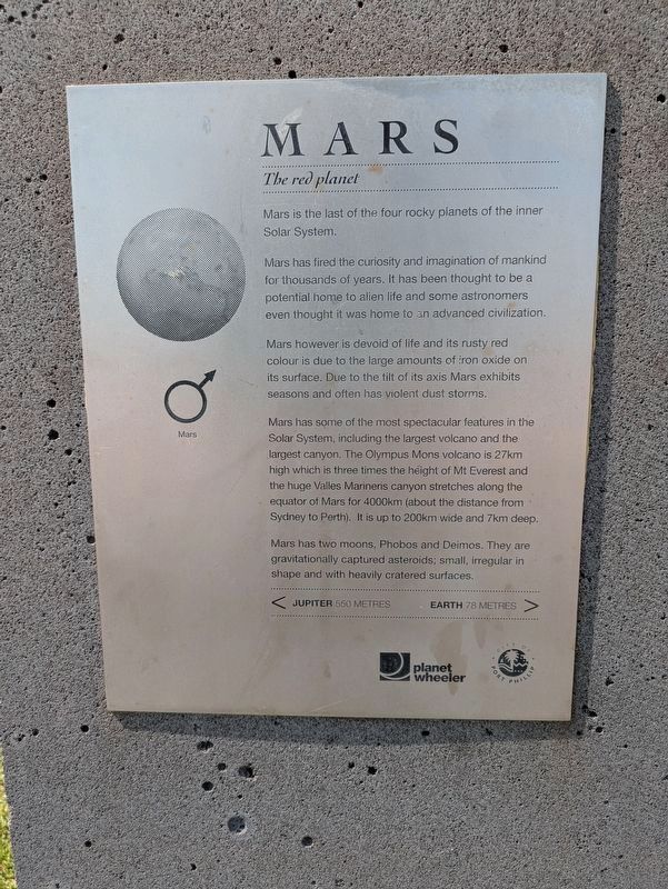
Mars has fired the curiosity and imagination of mankind for thousands of years. It has been thought to be a potential home to alien life and some astronomers even thought it was home to an advanced civilization.
Mars however is devoid of life and its rusty red colour is due to the large amounts of iron oxide on its surface. Due to the tilt of its axis Mars exhibits seasons and often has violent dust storms.
Mars has some of the most spectacular features in the Solar System, including the largest volcano and the largest canyon. The Olympus Mons volcano is 27km high which is three times the height of Mt Everest and the huge Valles Marineris canyon stretches along the equator of Mars for 4000km (about the distance from Sydney to Perth). It is up to 200km wide and 7km deep.
Mars has two moons, Phobos and Deimos. They are gravitationally captured asteroids; small, irregular in shape and with heavily cratered surfaces.
< Jupiter 550 Metres - Earth 78 Metres >
Erected by Planet Wheeler and City of Port Phillip. (Marker Number 5.)
Topics and series.
this page online
Location. 37° 52.21′ S, 144° 58.553′ E. Marker is in St Kilda, Victoria, in Port Phillip. It can be reached from Jacka Boulevard (Victoria Route 33) 0.2 kilometers south of Shakespeare Grove. Touch for map. Marker is at or near this postal address: 20 Jacka Boulevard, St Kilda VIC 3182, Australia. Touch for directions.

Regionally, it is in Oceania, in Australasia, in the Pacific Ocean, in South Pacific, on the Pacific Rim, in the Western World, and in the Anglosphere. Historically, it finds itself in what was once a British colony.
Other nearby markers. At least 8 other markers are within walking distance of this marker: Earth (within shouting distance of this marker); Venus (about 120 meters away, measured in a direct line); Mercury (about 180 meters away); Sun (about 210 meters away); Proxima Centauri (about 240 meters away); Great Scenic Railway (approx. 0.3 kilometers away); Councillor Edward O'Donnell (approx.
Photographed by Dean Barton-Ancliffe, September 29, 2026
2. Mars Marker Side Panel
Also see . . . Solar System Trail. Walks in Port Phillip
Navigate the solar system from the sun to the outer planets by following the bike and walking trail on the City of Port Phillip’s foreshore.(Submitted on November 4, 2026, by Dean Barton-Ancliffe of Rowville, Victoria.)
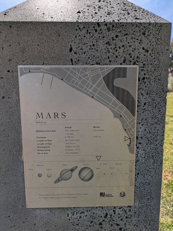
In 2008 artists and scientists constructed a model of our solar system to a scale of one to one billion between St Kilda and Port Melbourne. Instead of navigating 4.5 billion kilometres from the sun to Neptune, and 5.9 billion kilometres from the sun to Pluto, you only travel 4.5 kilometres and 5.9 kilometres.
The foreshore has always been a superb location to view the sun setting on the western horizon. Port Phillip Bay’s crescent shape is perfect for a model where the ‘sun’ can be viewed from every one of the nine model locations.
Credits. This page was last revised on November 5, 2026. It was originally submitted on November 4, 2026, by Dean Barton-Ancliffe of Rowville, Victoria. This page has been viewed 7 times since then. Photos: 1, 2. submitted on November 4, 2026, by Dean Barton-Ancliffe of Rowville, Victoria. • Andrew Ruppenstein was the editor who published this page.
