Northampton in West Northamptonshire, England, United Kingdom — Northwestern Europe (the British Isles)
Northampton Castle
1080-1879
Photographed by Ray Gurganus, May 25, 2026
1. Northampton Castle Marker
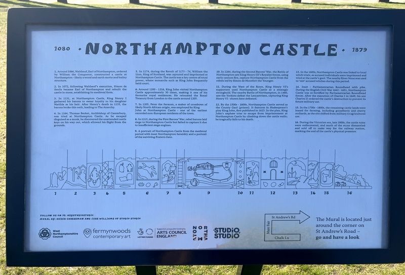
1. Around 1066, Walther, Earl of Northampton, ordered by William the Conqueror, constructed a castle at Northampton-likely a wood and earth motte and bailey structure.
2. In 1072, owing Waltheof's execution, Simon de Senlis became Earl of Northampton and rebuilt the castle in stone, establishing is medieval form.
3. 1131, Northampton Castle, King Henry I gathered his barons to wear loyalty to his daughter Mathilda as his heir. After Henry's death in 1135, the barons broke this oath, leading to The Anarchy.
4. In 1164, Thomas Becket, Archbishop of Canterbury, wasted at Northampton Castle. As he escaped disguised as a monk, he discovered the unattended castle keys on his way out, which allowed his flight from the grounds.
5. In 1174, during the Revolt of 1173-74, William the Lion, King of Scotland, was captured and imprisoned at Northampton Castle. The castle was a key centre of royal power, where monarchs such as King John frequently held court.
6. Around 1200-1216, King John visited Northampton Castle approximately 30
this page online
7. In 1205, Peter the Saracen, a maker of crossbows of likely North African origin, was employed by King John at Northampton Castle one of the earliest recorded non-European residents of the town.
8. In 1215, during the First Barons' War, rebel barons laid siege to Northampton Castle but failed to capture it due to insufficient siege engines.
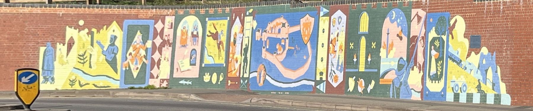
9. A portrait of Northampton Castle from the medieval period with inset Northampton heraldry and a portrait of the surviving Postern Gate.
10. In 1264, during the Second Barons' War, the Battle of Northampton saw King Henry III's Royalist forces, using early cannon fire, capture Northampton Castle from the rebels led by Simon de Montfort the Younger.
11. During the Wars of the Roses, King Henry VI's supporters used Northampton Castle as a strategic stronghold. The nearby Battle of Northampton, in 1460, saw the Yorkists defeat the Lancastrians, capturing King Henry VI - shown here defeated.
12. By the 1500s - 1600s, Northampton Castle served as the County
Photographed by Ray Gurganus, May 25, 2026
2. Northampton Castle Mural
13. In the 1600s, Northampton Castle was linked to local witch trials, as accused individuals were imprisoned and tried at the castle's gaol. The nearby River Nene was used to 'test' accused witches during this period.
14. Inset Parliamentarian Roundhead with pike. During the English Civil War 1642 - 1651, Northampton Castle was re-fortified by Parliamentarian Roundhead forces. After the execution of Charles I in 1649, his son Charles II ordered the castle's destruction to prevent its future military use.
15. In the 1700s - 1800s, the remaining castle lands were leased for farming, including gooseberry and cherry orchards, as the site shifted from military to agricultural use.
16. During the Victorian era, late 1800s, the castle ruins were rediscovered, and much of the stone dismantled and sold off to make way for the railway station, marking the end of the castle's physical presence.
Erected by West Northampton Council.
Topics. This historical marker is listed in these topic lists: Arts, Letters, Music • Forts and Castles. A significant historical year for this entry is 1066 CE.
Location. 52° 14.251′ N, 0° 54.226′ W. Marker is in Northampton, England, in West Northamptonshire. It is on Chalk Lane. Touch for map. Marker is at or near this postal address: 14 Chalk Lane, Northampton, England NN1 2RW, United Kingdom. Touch for directions.

Regionally, it is on the Atlantic Ocean, in the North Atlantic Region, in Europe, in Atlantic Europe, on one of the British Isles, in the Western World, and in the Anglosphere. Historically, it finds itself in what was once the Roman Empire.
Other nearby markers. At least 8 other markers are within walking distance of this marker: Royals and the Castle (a few steps from this marker); Stories from the Castle (a few steps from this marker); Hazelrigg House and the Old Black Lion (a few steps from this marker); The Fall of the Castle Walls (a few steps from this marker); Thomas Becket (a few steps from this marker); Visitors to the Castle (a few steps from this marker); The Castle (a few steps from this marker); The Story of Simon de Senlis (within shouting distance of this marker). Touch for a list and map of all markers in Northampton.
Credits. This page was last revised on November 10, 2026. It was originally submitted on November 7, 2026, by Ray Gurganus of Washington, District of Columbia. This page has been viewed 4 times since then. Photos: 1, 2. submitted on November 7, 2026, by Ray Gurganus of Washington, District of Columbia. • Andrew Ruppenstein was the editor who published this page.
