
Downtown in Tenino in Thurston County, Washington — The American West (Northwest)
Tenino's Historic Walking Tour
Photographed by Shirley A Stirling, November 13, 2026
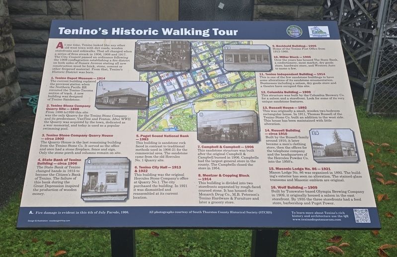
1. Tenino's Historic Walking Tour Marker
At one time, Tenino looked like any other old west town with dirt roads, wooden storefronts, and sidewalks. That all changed when a series of fires struck in 1906, 1908 and 1917. The City Council passed an ordinance following the 1908 conflagration establishing a fire district on both sides of Sussex Avenue, stating all new construction must be brick, stone, cement or other fireproof material. From that, Tenino's Historic District was born.
1. Tenino Depot Museum – 1914
The current building replaced the previous station when the Northern Pacific RR rerouted the Tenino-Tacoma section of track. A new building was designed of Tenino Sandstone.
2. Tenino Stone Company Quarry Site – 1888
From 1888 to 1926 this site was the only Quarry for the Tenino Stone Company and its predecessor, Van Tine and Fenton. After WWII the Quarry was acquired by the town, dedicated as a war memorial, and today is used as a popular swimming pool.
3. Tenino Stone Company Quarry House – circa 1900
The Quarry House is the last remaining building from the Tenino Stone Co. It served as the office and once had a stone fireplace, fence and sign.
this page online
4. State Bank of Tenino Building – circa 1906
The State Bank of Tenino changed hands in 1915 to become the Citizen's Bank of Tenino. The failure of this bank during the Great Depression inspired the production of wooden money.
5. Puget Sound National Bank – 1983
This building is sandstone rock faced in contrast to traditional methods used 1906–21 for the commercial area. The sandstone came from the old Hercules No. 1 Quarry site.
6. Tenino City Hall – 1913 & 1922
This building was the original Hercules Stone Company's office at Quarry No. 1. In 1921 the city purchased the building, dismantled it and reassembled it at its current location.
7. Campbell & Campbell – 1906
This sandstone structure was built after the original Campbell & Campbell burned in 1906. Campbells had the largest general store in the county. The Campbells closed the store in 1954.
8. Mentzer & Copping Block – 1914
This building is divided into two storefronts separated by rough-faced coursed stone. It has housed the Monarch Drug Co., M.B. Peterson's Tenino Hardware & Furniture and later a grocery
Photographed by Shirley A Stirling, November 13, 2026
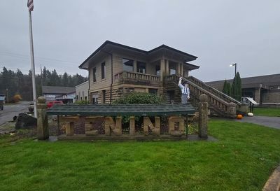
2. Wide view of Tenino's Historic Walking Tour Marker
The marker is located in the far right of this photo.
9. Bockhold Building – 1906
Home of the Tenino Post Office from 1913–1960.
10. Miler Block – 1906
Over the years it has housed The State Bank, a confectionery, meat market, dry goods store, hardware store, and Western Auto, to name a few.
11. Tenino Independent Building – 1914
This is one of the few sandstone buildings to have some alterations of its sandstone ornamentation. Businesses including a saloon, dry goods store and a theatre have occupied this site.
12. Columbia Building – 1909
This structure was built by the Columbia Brewery Co. in 1909 for a saloon and storefront. Look for some of its very unique sandstone features.
13. Russell House – 1892
This was originally a small, wooden two-bedroom 1892 rectangular house. In 1911, Thomas Russell of the Tenino Stone Co. built an addition to the west side. This house has been maintained with little alteration.
14. Russell Building – circa 1910
Built by the Russell family around 1910, it later became a men's clothing store, then the offices for the telephone company and the headquarters of the Hercules Powder Co. into the 1950s.
15. Masonic Lodge No. 86 – 1921
Mason Lodge No. 86 was organized in 1892. The building's exterior has seen no alteration. The stained-glass transoms and Masonic emblem are original.
16. Wolf Building – 1909
Built by Tumwater-based Olympia Brewing Company in 1909, it originally housed a saloon in the east storefront. By 1935 the three storefronts had a feed store, barbershop and Puget Power.
To learn more about Tenino's rich history and architecture, use the QR
www.teninodepotnuseum.com
All photographs courtesy of South Thurston County Historical Society (STCHS)
A. Fire damage is evident in this 4th of July Parade, 1906.
Design & illustration: noeldesigninterp.com
Erected by City of Tenino and Thurston County.
Topics. This historical marker is listed in these topic lists: Architecture • Settlements & Settlers. A significant historical year for this entry is 1908.
Location. 46° 51.449′ N, 122° 51.106′ W. Marker is in Tenino, Washington, in Thurston County. It is in Downtown. It is at the intersection of Sussex Avenue West and Hodgen Street, on the right when traveling east on Sussex Avenue West. The marker is at the bottom of the steps of the old City Hall building. Touch for map. Marker is at or near this postal address: 125 Sussex Street West, Tenino WA 98589, United States of America. Touch for directions.

Regionally, this marker is in the Puget Sound Region and in Greater Seattle. It is also on the American Pacific Coast, in the Pacific Northwest, and in the Lewis & Clark Corridor. Globally, it is in North America, in the Inside Passage, on the Ring of Fire, on the Pacific Rim, in the Western Hemisphere, in the Western World, and in the Anglosphere.
Other nearby markers. At least 8 other markers are within walking distance of this marker: Tenino City Hall History (a few steps from this marker); State Bank of Tenino (within shouting distance of this marker); Old Oregon Trail (about 700 feet away, measured in a direct line); Lest We Forget (approx. 0.2 miles away); A History of Remembrance (approx. 0.2 miles away); The Tenino Stone Company Quarry House (approx. 0.2 miles away); Honor Roll (approx. 0.2 miles away); From Quarry to Public Pool (approx. 0.2 miles away). Touch for a list and map of all markers in Tenino.
Credits. This page was last revised on November 18, 2026. It was originally submitted on November 14, 2026, by Shirley A Stirling of Lacey, Washington. This page has been viewed 9 times since then. Photos: 1. submitted on November 14, 2026, by Shirley A Stirling of Lacey, Washington. 2. submitted on November 15, 2026, by Shirley A Stirling of Lacey, Washington. • James Hulse was the editor who published this page.
