
King's Lynn in Norfolk, England, United Kingdom — Northwestern Europe (the British Isles)
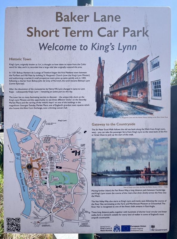
Welcome to King's Lynn
Photographed by Ray Gurganus, April 29, 2026
1. Welcome to King's Lynn Marker
Historic Town
King's Lynn, originally known as 'Lin', is thought to have taken its name from the Celtic word for lake, and it is recorded that a large tidal lake originally covered this area.
In 1101 Bishop Herbert de Losings of Thetford began the first Medieval town between the Purfleet and Mill Fleet by building St. Margaret's Church (now the King's Lynn Minster) and authorising a market. A small prosperous town grew up quite quickly and, in 1204. following a charter from Bishop John de Grey of Norwich, the town became Bishop's Lynn (Lenne Episcopi).
After the dissolution of the monasteries by Henry VIII Lynn changed it name to Lynn Regis - subsequently King's Lynn-remaining an active port to this day.
The town has so many fascinating secrets to discover-the unique tide clock on the King's Lynn Minster, and the opportunity to see three different 'clocks' on the Saturday Market Place; and the carving of the 'witch's heart' on one of the buildings in the magnificent Georgian Tuesday Market Place, one of England's grandest town squares which also houses the Alive Corn Exchange, now a thriving concert
this page online
Gateway to the Countryside
The Sir Peter Scott Walk follows the old sea bank along the Wash from King's Lynn west-you can take the passenger ferry from King's Lynn to the west bank of the River Great Ouse to pick up the start of this walk.
Moving further inland, the Fen Rivers Way, a long distance path between Cambridge and King's Lynn traces the course of the rivers that drain slowly across the Fens into the Wash.
The Nar Valley Way also starts at King's Lynn and tracks east, following the course of the River Nar, terminating at the Farm and Workhouse Museum at Gressenhall. The River Nar is recognised as one of the finest chalk streams in East Anglia.
These long distance paths, together with hundreds of shorter local circular and linear walks, form a network suitable for every kind of walker in some of England's most unspoilt countryside.
Erected by Borough Council of King's Lynn & West Norfolk.
Topics. This historical marker is listed in this topic list: Settlements & Settlers.
Location. 52° 45.182′ N, 0° 23.686′ E. Marker is in King's Lynn, England, in Norfolk. It is on Baker Lane, on the right when traveling east. Touch for map. Marker is at or near this postal address: 54 Baker Lane, King's Lynn, England PE30 1HZ, United Kingdom. Touch for directions.

Regionally, this marker is in East Anglia. Globally, it is on the Atlantic Ocean, in the North Atlantic Region, in Europe, in Atlantic Europe, on one of the British Isles, in the Western World, and in the Anglosphere. Historically, it finds itself in what was once the Roman Empire and also the Hanseatic League.
Other nearby markers. At least 8 other markers are within walking distance of this marker: Baker Lane Oil Cake Mill (within shouting distance of this marker); Hall of the Guild of the Holy and Undivided Trinity (about 120 meters away, measured in a direct line); King John (1167-1216) (about 120 meters away); Gaol House (about 120 meters away); Welcome to the Saturday Market Place (about 120 meters away); King's Lynn Town Hall (about 120 meters away); The Chapel and Charnel House (about 120 meters away); The Priory and Parish of St Margaret (about 150 meters away). Touch for a list and map of all markers in King's Lynn.
Credits. This page was last revised on November 19, 2026. It was originally submitted on November 14, 2026, by Ray Gurganus of Washington, District of Columbia. This page has been viewed 7 times since then. Photo 1. submitted on November 14, 2026, by Ray Gurganus of Washington, District of Columbia. • Andrew Ruppenstein was the editor who published this page.
