
Southwark in Greater London, England, United Kingdom — Northwestern Europe (the British Isles)
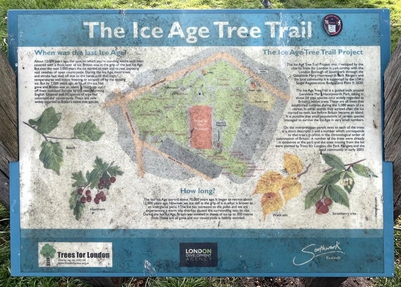
The Ice Age Tree Trail
Photographed by Ray Gurganus, April 8, 2026
1. The Ice Age Tree Trail Marker
When was the last Ice Age?
About 12,000 years ago, the spot on which you're standing would have been covered with a thick layer of ice. Britain was in the grip of the last Ice Age. But over the next 5,000 years the ice started to melt and retreat, exposing vast swathes of open countryside. During the Ice Age, most trees and shrubs had died off due to the harsh cold that kept temperatures well below freezing or scraped off by the moving ice. But by 7,000 years ago, most of the ice had gone and Britain was an island. It had been cut off from mainland Europe by the newly forming English Channel and 34 species of tree had colonised our countryside. These are now widely regarded as Britain's native tree species.
How long?
The last Ice Age started about 70,000 years ago. It began to retreat about 12,000 years ago. However, we are still in the grip of it in what is known as an interglacial period. The ice has retreated to the poles and we are experiencing a warm blip that has caused the surrounding seas to rise. During the last Ice Age, Britain was covered in sheets of ice up to 300 metres thick. These are all gone and our
this page online
The Ice Age Tree Trail Project
The Ice Age Tree Trail Project was developed by the charity Trees for London in partnership with the London Borough of Southwark through the Geraldine Mary Harmsworth Park Rangers and the local community. It is supported by the LDA's Single Regeneration Budget and Plant It 2020.
The Ice Age Tree Trail is a guided walk around Geraldine Mar Harmsworth Park, taking in those 34 tree species now widely regarded as Britain's native trees. These are all trees that established colonies during the 5,000 years of ice retreat. In other words they arrived after the ice started to melt, but before Britain became an island. It is possible that small populations of certain species managed to survive the Ice Age in very small numbers.
On the interpretation panels next to each of the trees is a short description and a number which corresponds to that tree's position in the chronological order of colonisation of Britain. A number of the trees were already in existence at the park and the ones missing from the list were planted by Trees for London, the Park Rangers and the local community in early 2003.
Erected by Southwark Council.
Topics. This historical marker is listed in this topic list: Horticulture & Forestry.
Location. 51° 29.808′ N, 0° 6.421′ W. Marker is in Southwark, England, in Greater London. It can be reached from Saint George's Road, on the left when traveling west. The marker is located in Geraldine Mary Harmsworth Park. Touch for map. Marker is at or near this postal address: 91 St George's Road, Southwark, England OF FREEDOM#, United Kingdom. Touch for directions.

Regionally, this marker is in London and in the Greater South East. Globally, it is on the Atlantic Ocean, in the North Atlantic Region, in Europe, in Atlantic Europe, on one of the British Isles, in the Western World, and in the Anglosphere. Historically, it finds itself in what was once the Roman Empire.
Other nearby markers. At least 8 other markers are within walking distance of this marker: Section of the Berlin Wall (about 90 meters away, measured in a direct line); British 15-inch naval guns (about 120 meters away); St George's Fields (about 150 meters away); Soviet World War II Memorial (about 180 meters away); One Mile from London Bridge (approx. 0.3 kilometers away); Craigie Aitchison (approx. 0.4 kilometers away); The Faraday Memorial (approx. half a kilometer away); Welcome to St Mary's Churchyard (approx. 0.6 kilometers away). Touch for a list and map of all markers in Southwark.
Credits. This page was last revised on November 18, 2026. It was originally submitted on November 16, 2026, by Ray Gurganus of Washington, District of Columbia. This page has been viewed 3 times since then. Photo 1. submitted on November 16, 2026, by Ray Gurganus of Washington, District of Columbia. • Andrew Ruppenstein was the editor who published this page.
