Sullivans Island in Charleston County, South Carolina — The American South (South Atlantic)
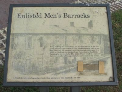
Enlisted Men's Barracks
A Confederate photographer took this picture of the barracks in 1861.
Topics. This historical marker is listed in these topic lists: Forts and Castles • War, US Civil. A significant historical year for this entry is 1809.
Location. 32° 45.571′ N, 79° 51.494′ W. Marker is on Sullivans Island, South Carolina, in Charleston County. Marker can be reached from Middle Street, on the right when traveling east. Located at stop five of the tour of Fort Moultrie National Monument. Touch for map. Marker is in this post office area: Sullivans Island SC 29482, United States of America. Touch for directions.
Other nearby markers. At least 8 other markers are within walking distance of this marker. Harbor Defense 1809-1860 (here, next to this marker); Powder Magazine (a few steps from this marker); Traverse c.1820 (a few steps from this marker); Defending Charleston 1861-1865 (within shouting distance of this marker); Building Forts (within shouting distance of this marker); Move a 50,000 pound Rodman Gun (within shouting distance of this marker); Northwest Bastionet (within shouting distance of this marker); Harbor Defense (within shouting distance of this marker). Touch for a list and map of all markers in Sullivans Island.
Credits. This page was last revised on June 16, 2016. It was originally submitted on June 17, 2010, by Craig Swain of Leesburg, Virginia. This page has been viewed 631 times since then and 17 times this year. Photos: 1, 2. submitted on June 17, 2010, by Craig Swain of Leesburg, Virginia.
Editor’s want-list for this marker. Photo of the foundation trace. • Can you help?

