Wythe in Hampton, Virginia — The American South (Mid-Atlantic)
The Hampton Roads Golf And Country Club
First in Virginia & One of the First 100 in the Country
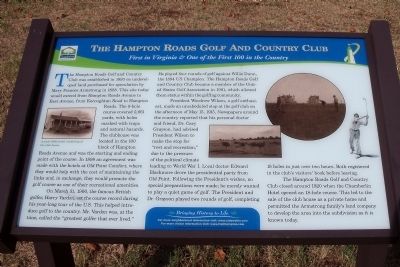
On March 31, 1900, the famous British golfer, Harry Vardon, set the course record during his year-long tour of the U.S. This helped introduce golf to the country. Mr. Vardon was, at the time, called the “greatest golfer that ever lived.” He played four rounds of golf against Willie Dunn, the 1894 US Champion. The Hampton Roads Golf and Country Club became a member of the United States Golf Association in 1901, which allowed them status within the golfing community.
President Woodrow Wilson, a golf enthusiast, made an unscheduled stop at the golf club on the afternoon of May 15, 1915, Newspapers around the country reported that his personal doctor and friend, Dr. Cary Grayson, had advised President Wilson to make the stop for “rest and recreation,” due to the pressure of the political climate leading to World War I. Local doctor Edward Blackmore drove the presidential party from Old Point. Following the President’s wishes, no special preparations were made; he merely wanted to play a quiet game of golf. The President and Dr. Grayson played two rounds of golf, completing 18 holes in just over two hours. Both registered in the club’s visitors’ book before leaving.
The Hampton Roads Golf and Country Club closed around 1920 when the Chamberlin Hotel opened an 18-hole course. This led to the sale of the club house as a private home and permitted the Armstrong family’s land company to develop the area into the subdivision as it is known today.
Bringing History to Life
For more neighborhood information visit: www.oldewythe.com
For more visitor information visit: www.VisitHampton.com
In partnership with Virginia Civil War Trails, www.civilwartrails.org
Erected by Olde Wythe Neighborhood Association.
Topics and series. This historical marker is listed in these topic lists: Parks & Recreational Areas • Sports. In addition, it is included in the Former U.S. Presidents: #28 Woodrow Wilson series list. A significant historical month for this entry is March 1859.
Location. 37° 0.007′ N, 76° 22.144′ W. Marker is in Hampton, Virginia. It is in Wythe. Marker is at the intersection of Chesapeake Avenue (Virginia Route 167) and Hampton Roads Avenue, on the left when traveling south on Chesapeake Avenue. Touch for map. Marker is in this post office area: Hampton VA 23661, United States of America. Touch for directions.
Other nearby markers. At least 8 other markers are within walking distance of this marker. Hampton Roads – World’s Greatest Harbor (about 500 feet away, measured in a direct line); Admiral Sir George Cockburn on the Chesapeake / The War of 1812 (about 500 feet away); Olde Wythe During Colonial Times (approx. 0.2 miles away); Indian River Park – In The Heart Of Olde Wythe (approx. ¼ mile away); Sack of Hampton / The War of 1812 (approx. ¼ mile away); The Development Of Olde Wythe (approx. 0.3 miles away); Fertile Hunting Grounds For The Indians (approx. 0.4 miles away); Stalemate in Hampton Roads (approx. half a mile away). Touch for a list and map of all markers in Hampton.
More about this marker. On the left is "A early 1900 artist rendering of the club house." and on the right are photos of the golf course.
Also see . . .
1. Olde Wythe Neighborhood Association. (Submitted on August 2, 2010, by Bernard Fisher of Richmond, Virginia.)
2. Memories and History of Hampton Virginia’s Olde Wythe Neighborhood. (Submitted on August 2, 2010, by Bernard Fisher of Richmond, Virginia.)
3. Hampton Convention & Visitor Bureau. (Submitted on August 2, 2010, by Bernard Fisher of Richmond, Virginia.)
4. Virginia Civil War Trails. (Submitted on August 2, 2010, by Bernard Fisher of Richmond, Virginia.)
Credits. This page was last revised on February 1, 2023. It was originally submitted on August 2, 2010, by Bernard Fisher of Richmond, Virginia. This page has been viewed 1,298 times since then and 76 times this year. Photos: 1, 2. submitted on August 2, 2010, by Bernard Fisher of Richmond, Virginia.

