Tulsa in Tulsa County, Oklahoma — The American South (West South Central)
First Oil Well in Tulsa County
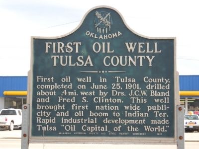
Photographed by Tim Connor, circa June 26, 2009
1. First Oil Well in Tulsa County Marker
Erected 1949 by Oklahoma Historical Society.
Topics and series. This historical marker is listed in these topic lists: Industry & Commerce • Settlements & Settlers. In addition, it is included in the Oklahoma Historical Society series list. A significant historical month for this entry is June 1941.
Location. 36° 6.274′ N, 96° 1.396′ W. Marker is in Tulsa, Oklahoma, in Tulsa County. It is on Southwest Boulevard (State Highway 66) south of West 41st Street South, in the median. Touch for map. Marker is at or near this postal address: 4244 Southwest Boulevard, Tulsa OK 74107, United States of America. Touch for directions.

Regionally, this marker is in the Muscogee Nation, specifically in the Cherokee Nation, and in Northeast Oklahoma—Green Country. It is also in the American South, specifically on the prairies, and on the Southern Plains. Globally, it is in North
this page online
Other nearby markers. At least 8 other markers are within walking distance of this marker: Red Fork (about 300 feet away, measured in a direct line); Crystal City (approx. ¼ mile away); Settlement of the Nations 1836-1866 (approx. ¼ mile away); Transition 1866-1901 (approx. ¼ mile away); A New Century 1901-1926 (approx. ¼ mile away); The Motoring Public 1926 (approx. ¼ mile away); Route 66 Historical Village (approx. half a mile away); Clinton Heights (approx. 0.6 miles away). Touch for a list and map of all markers in Tulsa.
Credits. This page was last revised on September 2, 2021. It was originally submitted on August 7, 2010, by Tim Connor of Owasso, Oklahoma. This page has been viewed 2,742 times since then and 114 times this year. Photo 1. submitted on August 7, 2010, by Tim Connor of Owasso, Oklahoma. • Syd Whittle was the editor who published this page.
Editor’s want-list for this marker. A photo of the marker and the surrounding area in context. • Can you help?
