Near Zephyr Cove in Douglas County, Nevada — The American Mountains (Southwest)
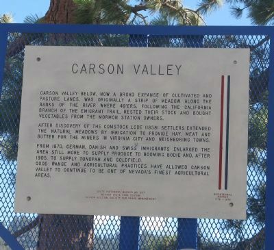
Carson Valley
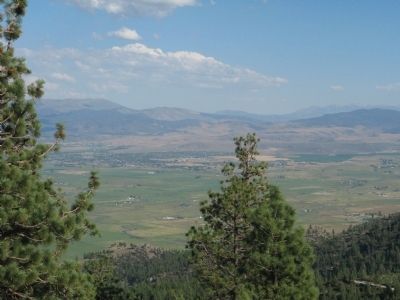
Carson Valley below, now a broad expanse of cultivated and pasture lands, was originally a strip of meadow along the banks of the river where 49’ers, following the California branch of the emigrant trail, rested their stock and bought vegetables from the Mormon Station owners.
After discovery of the Comstock Lode (1858) settlers extended the natural meadows by irrigation to provide hay, meat and butter for the miners in Virginia City and neighboring towns.
From 1870, German, Danish and Swiss immigrants enlarged the area still more to supply produce to booming Bodie and, after 1905, to supply Tonopah and Goldfield.
Good range and agricultural practices have allowed Carson Valley to continue to be one of Nevada’s finest agricultural areas.
Erected by Nevada State Park System and Nevada Section, Society of Range Management. (Marker Number 207.)
Topics. This historical marker is listed in these topic lists: Agriculture • Settlements & Settlers. A significant historical year for this entry is 1870.
Location. 38° 58.456′ N, 119° 52.606′ W. Marker is near Zephyr Cove, Nevada, in Douglas County. Marker is on Kinsbury Grade (State Highway 207), on the right when traveling east. Marker is east of the Heavenly Valley Ski Resort. Touch for map. Marker is in this post office area: Zephyr Cove NV 89448, United States of America. Touch for directions.
Other nearby markers. At least 8 other markers are within 3 miles of this marker, measured as the crow flies. The Cary Mill (approx. 2.1 miles away); The Demise of Sam Brown (approx. 2.1 miles away); Kingsbury Grade (approx. 2.1 miles away); Walley's Hot Springs (approx. 2.4 miles away); Carson Trail - Hot Springs (approx. 2.4 miles away); The Territorial Enterprise & the Telegraph (approx. 2.6 miles away); Originally – The Raycraft Dance Hall (approx. 2.6 miles away); The Jackass Express (approx. 2.6 miles away).
Regarding Carson Valley. David W. Toll writes in his History of Minden (http://www.nevadaweb.com/cnt/r-t/minden/index.html), “The Carson Valley is one of the earliest-settled, richest, and most productive of the state¹s agricultural regions. In spring, summer, and autumn, when the valley is bursting with life, the vast irrigated tracts are a green velvet patchwork quilt upon which the stacks of baled hay stand like giant cheese, and cottonwoods and poplars rise up like flashing green flames. The meadows are sopped with water from the Sierra, fat and languid cattle browse placidly everywhere.”
Also see . . .
1. Carson Valley’s Rich History
. Carson City website entry (Submitted on December 31, 2021, by Larry Gertner of New York, New York.)
2. New Amended Text for Marker. The Nevada State Historic Preservation Office (SHPO) recently updated the text of the roughly 260 state historical markers in Nevada. The Nevada SHPO placed the amended text of each individual marker on its website and will change the actual markers in the field as funding allows. Changes have been made to this marker for grammar, readability, and content. The portion of the sentence "and bought vegetables from the Mormon Station owners" has been removed, and the year of discovery of the Comstock Lode has been changed from 1858 to 1859. The link will take you to the Nevada SHPO page for the marker with the amended text. (Submitted on October 25, 2013, by Duane Hall of Abilene, Texas.)
Credits. This page was last revised on December 31, 2021. It was originally submitted on August 17, 2010, by Syd Whittle of Mesa, Arizona. This page has been viewed 785 times since then and 17 times this year. Photos: 1, 2, 3. submitted on August 17, 2010, by Syd Whittle of Mesa, Arizona.


