Falmouth in Stafford County, Virginia — The American South (Mid-Atlantic)
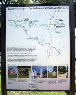
Fredericksburg and Spotsylvania National Military Park
National Park Service, U.S. Department of the Interior
Inscription.
Fredericksburg, Chancellorsville, Wilderness, and Spotsylvania—this is the bloodiest landscape in North America. No place more vividly reflects the Civil War’s tragic cost in all its forms. A city bombarded, bloodied, and looted. Farms large and small ruined. Refugees by the thousands forced into the countryside. More than 85,000 men wounded; 15,000 killed—most now in graves unknown.
The fading scars of battle, the home places of bygone families, and the granite tributes to those who fought still mark these lands. These places reveal the trials of a community and nation at war—a virtuous tragedy that freed four million Americans and reunited a nation. To visit the battlefields, begin your tour at either the Fredericksburg Battlefield Visitor Center or the Chancellorsville Battlefield Visitor Center.
[Captions:]
Wilderness Battlefield
For two days Union and Confederate soldiers grappled with one another in the woods 15 miles west of Fredericksburg. James Horace Lacy’s house, “Ellwood,” was a headquarters during the battle.
Chancellorsville Battlefield
Robert E. Lee forged a victory against great odds here but suffered the irreparable loss of his brilliant subordinate “Stonewall” Jackson.
Spotsylvania Battlefield
Two weeks of gruesome combat culminated in hand-to-hand fighting at this turn in the Confederate line, known as the Bloody Angle.
Jackson Shrine
After his mortal wounding at Chancellorsville, “Stonewall” Jackson was taken to a Caroline County plantation, where he died eight days later. His final words were, “Let us cross over the river and rest under the shade of the trees.”
Fredericksburg Battlefield
Protected by a stone wall, Confederate defenders turned back wave after wave of brave but futile Union assaults at the Sunken Road.
Erected 2010 by National Park Service, U.S. Department of the Interior.
Topics. This historical marker is listed in this topic list: War, US Civil.
Location. 38° 18.541′ N, 77° 27.262′ W. Marker is in Falmouth, Virginia, in Stafford County. Marker can be reached from Chatham Drive near Chatham Heights Road. Touch for map. Marker is at or near this postal address: 101 Chatham Dr, Fredericksburg VA 22404, United States of America. Touch for directions.
Other nearby markers. At least 8 other markers are within walking distance of this marker. Chatham (here, next to this marker); Beyond the Big House (here, next to this marker); Chatham and the Civil War (a few steps from this marker); a different marker also named Chatham (a few steps from this marker); A Changed Landscape
(within shouting distance of this marker); Sow…Tend…Harvest (within shouting distance of this marker); A “Picture of Desolation” (about 600 feet away, measured in a direct line); Bombardment (about 600 feet away). Touch for a list and map of all markers in Falmouth.
More about this marker. This marker is a standard orientation marker and is repeated elsewhere in the park.
Also see . . . Fredericksburg & Spotsylvania National Military Park. National Park Service (Submitted on September 6, 2010.)
Credits. This page was last revised on September 30, 2022. It was originally submitted on September 6, 2010, by Bernard Fisher of Richmond, Virginia. This page has been viewed 913 times since then and 23 times this year. Photos: 1, 2. submitted on September 6, 2010, by Bernard Fisher of Richmond, Virginia.

