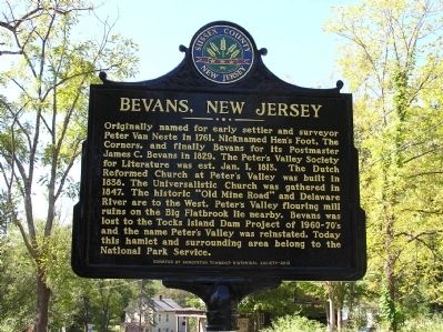
Layton near Sandyston in Sussex County, New Jersey — The American Northeast (Mid-Atlantic)
Bevans, New Jersey
Erected 2010 by Sandyston Township Historical Society.
Topics. This historical marker is listed in these topic lists: Churches & Religion • Roads & Vehicles • Settlements & Settlers. A significant historical month for this entry is January 1924.
Location. 41° 11.814′ N, 74° 51.017′ W. Marker is near Sandyston, New Jersey, in Sussex County. It is in Layton. Marker is on Kuhn Road (County Route 615) near Walpack Road and Kuhn Road when traveling north. Touch for map. Marker is at or near this postal address: 15 Kuhn Rd, Layton NJ 07851, United States of America. Touch for directions.
Other nearby markers. At least 8 other markers are within 5 miles of this marker, measured as the crow flies. The Village of Bevans (approx. 0.9 miles away); Dingmans Ferry (approx. 1.6 miles away in Pennsylvania); Layton, New Jersey (approx. 1.8 miles away); a different marker also named Dingman's Ferry (approx. 2.1 miles away in Pennsylvania); Stokes State Forest (approx. 2.9 miles away); Wallpack, N.J. (approx. 3.1 miles away); Roosevelt's Tree Army (approx. 4˝ miles away in Pennsylvania); Harnessing the Creek (approx. 4˝ miles away in Pennsylvania).
Additional commentary.
1. Bevans Historic Marker
This marker was dedicated on Sunday, Oct.3, 2010. It was paid for entirely with donations made by the members of the Sandyston Township Historical Society.
Sandyston Township is very proud of its history. Today this village, once known as Peter's Valley, changed to Bevans, and again to Peter's Valley in 1970, is part of the Delaware Water Gap National Recreational Area, this sign is placed on the right of way of a Sandyston Township, Sussex County, N.J. road right of way. Contacts: Sandyston Township Historical Society at Sandystontownship.org***or**
[email protected] for more information about this hamlet.
— Submitted February 5, 2013, by Patricia Haggerty Frato of Hainesville, N.j..
Credits. This page was last revised on August 28, 2023. It was originally submitted on September 29, 2010, by Cheryl (Rome) Thom of Newton, New Jersey. This page has been viewed 1,597 times since then and 44 times this year. Photo 1. submitted on September 29, 2010, by Cheryl (Rome) Thom of Newton, New Jersey. • Bill Pfingsten was the editor who published this page.
