Étretat in Seine-Maritime, Normandy, France — Western Europe
Nungesser and Coli's 1927 Flight
Photographed by Donald Olson, September 11, 2010
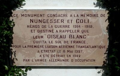
1. Nungesser and Coli's 1927 Flight Marker
(English translation):
This monument, dedicated to the memory of Nungesser and Coli, heroes of the war of 1914-1918, and intended to recall that their “White Bird” left the soil of France for the first transatlantic aerial crossing at Étretat on 8 May 1927, was destroyed in 1942 by the German army of occupation.
Topics. This historical marker is listed in this topic list: Air & Space. A significant historical date for this entry is May 8, 1927.
Location. 49° 42.667′ N, 0° 12.45′ E. Marker is in Étretat, Normandie (Normandy), in Seine-Maritime. It is on Avenue Damilaville, on the right when traveling west. Marker is accessible via a path leading up a cliff, the Falaise Amont, at the northeast end of the beach at Étretat, France. Touch for map. Marker is at or near this postal address: 9 Avenue Damilaville, Étretat, Normandie 76790,
this page online

Regionally, it is in the North Atlantic Region, Europe, the European Union, Atlantic Europe, the Schengen Area, Western Europe, a coastal Mediterranean country, and the Western World. Historically, it finds itself in what was once a French colony and also the Roman Empire.
Other nearby markers. At least one other marker is within walking distance of this marker: Étretat (approx. 0.4 kilometers away).
Regarding Nungesser and Coli's 1927 Flight. This marker is placed on the coast just northeast of Étretat, France, at the spot where pioneering aviators Charles Nungesser and François Coli were last seen from French soil on May 8, 1927, as they headed out to sea in their attempt to make the first non-stop transatlantic flight. The pair disappeared and their fate is considered one of aviation’s greatest unsolved mysteries.
Two weeks later Charles Lindbergh made his successful non-stop flight from New York’s Long Island to Paris.
The Nungesser and Coli monument on the cliff at Étretat includes the marker, a monumental “flèche” [“arrow”] pointing to the sky, and a stone
Photographed by Donald Olson, September 11, 2010
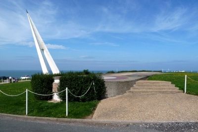
2. Ground level view
The Nungesser and Coli marker is visible among the bushes on the left. Also visible on the left is the monumental white “flèche” [“arrow”] pointing to the sky. The steps on the right lead up to the stone outline of their biplane, “L’Oiseau Blanc” [“The White Bird”].
The spectacular cliff called Falaise Amont, immediately northeast of Étretat, is home to both the Nungesser and Coli monument and also a small church called Chapelle Notre-Dame de la Garde.
The original Nungesser and Coli marker and monument at this spot were partially destroyed during World War II. The present marker and monument were completed in the early 1960s.
Related marker. Click here for another marker that is related to this marker. To better understand the relationship, study each marker in the order shown.
Also see . . .
1. Nungesser on Wikipedia. (Submitted on October 4, 2010, by Donald Olson of San Marcos, Texas, USA.)
2. Coli on Wikipedia. (Submitted on October 4, 2010, by Donald Olson of San Marcos, Texas, USA.)
3. The White Bird (biplane) on Wikipedia. (Submitted on October 4, 2010, by Donald Olson of San Marcos, Texas, USA.)
Photographed by Donald Olson, September 11, 2010
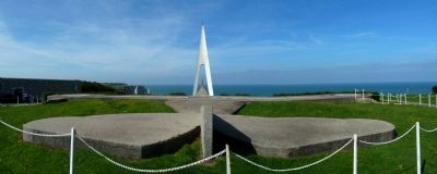
3. Panoramic ground level view from behind the stone airplane
The Nungesser and Coli marker is just below the left wingtip of the stone outline of their biplane, “L’Oiseau Blanc” [“The White Bird”]. The monumental white “flèche” [“arrow”] frames the steeple of Chapelle Notre-Dame de la Garde.
Photographed by Stéphane Dubost, circa 2007
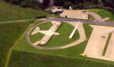
4. Aerial view
The Nungesser and Coli marker is just below the left wingtip of the stone outline of their biplane, “L’Oiseau Blanc” [“The White Bird”]. The building near the top of this photo is the Nungesser and Coli museum.
Photographed by Donald Olson, September 10, 2010
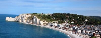
5. Falaise Amont and Étretat
The spectacular cliff called Falaise Amont, immediately northeast of Étretat, is home to both the Chapelle Notre-Dame de la Garde and the Nungesser and Coli monument. The church and the monumental white “flèche” [“arrow”] are both visible just left of center in this photo, as is the path leading from the beach up to the marker.
Photographed by Stéphane Dubost, circa 2007
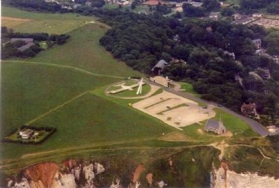
6. Aerial view including the monument and the church
The Nungesser and Coli marker and monument and the Chapelle Notre-Dame de la Garde are located on a cliff, the Falaise Amont, immediately northeast of Étretat.
Photographed by Donald Olson, September 9, 2010
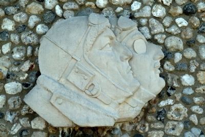
7. Profiles of Nungesser (left) and Coli (right)
The likenesses of the two pioneering aviators appear on the wall of the museum next to the marker.
Photographed by Donald Olson, September 9, 2010
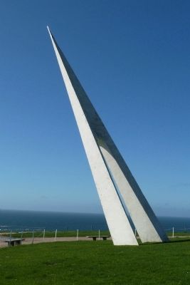
8. The Arrow
The monumental white “flèche” [“arrow”] points to the sky.
Credits. This page was last revised on September 9, 2018. It was originally submitted on October 4, 2010, by Donald Olson of San Marcos, Texas, USA. This page has been viewed 2,813 times since then and 60 times this year. Photos: 1, 2, 3, 4, 5, 6, 7, 8. submitted on October 4, 2010, by Donald Olson of San Marcos, Texas, USA. • Craig Swain was the editor who published this page.
