Marblehead in Essex County, Massachusetts — The American Northeast (New England)
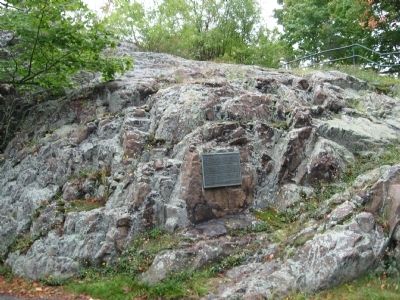
Bailey's Head
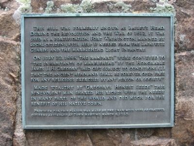
This hill was formerly known as Bailey's Head. During the Revolution and the War of 1812, it was used as a fortification, Fort Washington, manned by local citizens with help if needed from the Lafayette Guards and the Marblehead Light Infantry.
On July 22, 1888, "The Ramparts" were conveyed to "the inhabitants of Marblehead" by the Honorable James J.H. Gregory "said gift subject to conditions (1) that the ancient headland shall be forever open free for any religious exercises by any person or society."
Made wealthy by "Gregorys Honest Seeds" this benevolent man shared his riches with the needy in many parts of the world and did much for the benefit of his native town.
Provision for this plaque was made by the unanimous vote of grateful citizens assembled at town meeting March 8, 1965.
Erected 1965.
Topics. This historical marker is listed in these topic lists: Horticulture & Forestry • War of 1812. A significant historical date for this entry is March 8, 1638.
Location. 42° 30.63′ N, 70° 50.732′ W. Marker is in Marblehead, Massachusetts, in Essex County. Marker is at the intersection of Orne Street and Pond Street, on the right when traveling north on Orne Street. Touch for map. Marker is in this post office area: Marblehead MA 01945, United States of America. Touch for directions.
Other nearby markers. At least 8 other markers are within walking distance of this marker. Old Burial Hill (within shouting distance of this marker); Agnes Surriage Well (within shouting distance of this marker); Fort Sewall (approx. 0.2 miles away); a different marker also named Fort Sewall (approx. ¼ mile away); Fort Sewall Site Plan (approx. ¼ mile away); a different marker also named Fort Sewall (approx. ¼ mile away); Gen. Casimir Pulaski (approx. ¼ mile away); Huzzah! for "Old Ironsides" (approx. ¼ mile away). Touch for a list and map of all markers in Marblehead.
Regarding Bailey's Head. James John Howard Gregory (1827-1910) was born in Marblehead. He graduated from Amherst College in 1850 and taught school for several years. He returned to Marblehead to farm, and then entered the seed trade with a business that started in his home. It grew to become one of the largest in the world, earning him the title of "The Seed King." He was a poet, author, art collector, civic leader and generous to the town of Marblehead.
Also see . . . James J. H. Gregory, a timeline of his life. Save Seeds website entry (Submitted on October 5, 2010, by Michael Herrick of Southbury, Connecticut.)
Credits. This page was last revised on July 17, 2022. It was originally submitted on October 5, 2010, by Michael Herrick of Southbury, Connecticut. This page has been viewed 861 times since then and 19 times this year. Photos: 1, 2. submitted on October 5, 2010, by Michael Herrick of Southbury, Connecticut.

