Walloomsac in Rensselaer County, New York — The American Northeast (Mid-Atlantic)
A Gathering Storm
North
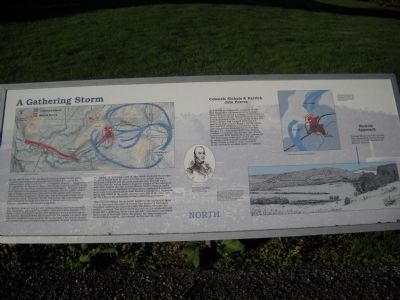
By the end of July 1777, the British invasion from Canada under General John Burgoyne had progressed to Fort Edward on the Hudson River. Desperately in need of supplies, Burgoyne dispatched an expedition on August 11 under Lieutenant Colonel Friedrich Baum to capture the American storehouses at Bennington, Vermont, which were thought to be guarded by only a handful of rebel militia. About half of Baumís troops were mercenaries who spoke only German. Although from Brunswick, these men, like all German troops, were commonly called “Hessians” by the Americans. The rest of Baumís force consisted of small detachments of British sharpshooters, Indians, Canadians, and American loyalists.
The British, however, had grossly underestimated American strength. New Hampshire had raised more than 1,500 men under General John Stark to meet Burgoyneís threat, and additional militia from Vermont and western Massachusetts also turned out. On August 14, aware that American resistance was growing, Baum encamped his troops on and around this hill, just five miles from Bennington, to await further reinforcements.
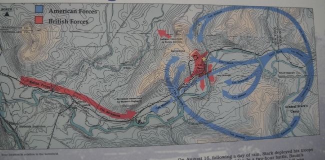
On August 16, following a day of rain, Stark deployed his troops to attack Baum from all sides. In a two-hour battle, Baumís outposts collapsed and his main position atop this hill was overrun, but not before Baumís dragoons fought off the attackers with their sabers. Too late to help Baum, reinforcements under Lieutenant Colonel Heinrich Von Breymann approached from the west, only to be driven off by Seth Warnerís Continental Regiment. Baum was killed in the battle, as were over 200 of his men, and all but a few of the remainder became American prisoners.
“Wherever the Kingís forces point, militia to the amount of three or four thousand assemble in twenty-four hours,” a frustrated Burgoyne wrote to his superiors after the defeat. Vermont, he added, contained “the most rebellious race on the continent, and hangs like a gathering storm upon my left.” The Americans made their stand at Saratoga, where Burgoyne, his army weakened by dwindling supplies, surrendered on October 17, 1777.
[ Sidebar: ]
Nicholsí Approach.
Erected by Bennington Battlefield State Historic Site.
Topics. This historical marker is listed in this topic list: War, US Revolutionary. A significant historical month for this entry is July 1777.
Location. 42° 56.309′ N, 73° 18.257′ W. Marker is in Walloomsac, New York, in Rensselaer County. Marker can be reached from New York State Route 67, on the left when traveling east. Marker is located in Bennington Battlefield State Historic Site. Touch for map. Marker is in this post office area: Hoosick Falls NY 12090, United States of America. Touch for directions.
Other nearby markers. At least 8 other markers are within walking distance of this marker. Bennington Battle Field (here, next to this marker); ďthe first link in the chain of successes which issued in the surrender at Saratoga ...Ē (here, next to this marker); ďHad day lasted an hour longer . . .Ē (a few steps from this marker); Bennington Battlefield (a few steps from this marker); Patriots of Vermont (within shouting distance of this marker); Massachusetts Volunteers at Bennington
(within shouting distance of this marker); New Hampshire Troops (within shouting distance of this marker); New Hampshire Regiment (within shouting distance of this marker). Touch for a list and map of all markers in Walloomsac.
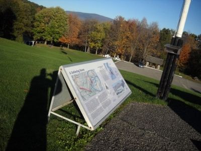
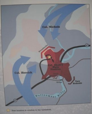
More about this marker. A battle map of the battlefield and troop movements is at the upper left of the marker. A second map shows the markerís location in relation to the battlefield. Indicated on this map are Col. Baumís main position, Tory redoubts and breastworks, and the approach of Col. Herrick's and Col. Nicholsí troops.
The bottom right of the marker contains a drawing of Nicholsí Approach. It has a caption of “This view is from the hill on the southwest bank of the Walloomsac River, a little west of the road from the Starksville bridge, looking northwest. From War Over Walloomscoick: Land Use and Settlement Pattern on the Bennington Battlefield – 1777, edited by Philip Lord. NYS Museum No. 473, the State Education Department.”
Also on the marker is an engraving of General John Stark from the Pictorial Field Book of the Revolution, Benson J. Lossing, 1855.
Also see . . .
1. Bennington Battlefield State Historic Site. New York State Office of Parks, Recreation & Historic Preservation website. (Submitted on October 10, 2010, by Bill Coughlin of Woodland Park, New Jersey.)
2. The Battle of Bennington. The American Revolutionary War website. (Submitted on October 10, 2010, by Bill Coughlin of Woodland Park, New Jersey.)
3. The Battle of Bennington 1777. An account of the Battle of Bennington from a British perspective from BritishBattles.com. (Submitted on October 10, 2010, by Bill Coughlin of Woodland Park, New Jersey.)
Credits. This page was last revised on February 21, 2021. It was originally submitted on October 10, 2010, by Bill Coughlin of Woodland Park, New Jersey. This page has been viewed 1,026 times since then and 31 times this year. Photos: 1, 2, 3, 4, 5. submitted on October 10, 2010, by Bill Coughlin of Woodland Park, New Jersey.
